Maps of South Aegean Region

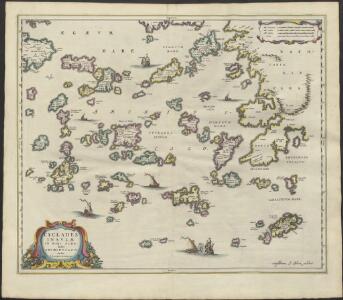
CYCLADES | INSVLÆ | IN MARE ÆGÆO, | hodie | ARCHIPELAGO
Auctore | I. LAVRENBERGIO Amsterdami, J. Blaeu excudit
Archipelagi Meridionalis seu Cycladum Insularum accurata Delineatio. [Karte], in: Novus atlas absolutissimus, Bd. 10, S. 234.
1 Karte aus Atlas Janssonius Offizin
Archipelagi meridionalis, seu Cycladum insularum accurata delineatio / auctore I. Laurenbergio
1 : 650000 Annotatie: Kaart uitgegeven in de periode 1650-1662; Origineel is Blad 171 in atlas factice; Annotatie geografische gegevens: 4 schaalstokken: 8 Mill. Germ., en: 10 Mill. Gall., en: 30 Mill. Ital., en: 300 Stadia [S.l.] : [s.n.]
Het zuijderdeel van de Archipel Lagusche Eijlanden int groodt
Greece Gerard van Keulen
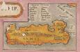
Insula Creta hodie Candia
1 : 900000 Kréta (Řecko) Homann, Johann Baptist Joh. Bapt. Homannus
Die Cycladischen Inseln
1 : 1160000 Kyklady (Řecko) Anville, Jean-Baptiste Bourguinon d'
Insula Creta nunc Candia
1 : 900000 Kréta (Řecko) Lotter, Tobias Conrad Tob. Conr. Lotter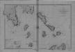
Begulia, Melada Island, Dalmatia
Port Beguglia ... Levé en 1819 par le Capit. W. H. Smyth. [Paris],
Archipelagi Insularum Aliquot Descrip., [Rodus] [Karte], in: Theatrum orbis terrarum, S. 341.
1 Karte aus Atlas Ortelius, Abraham Vrients, Jan Baptista
Rhodus Ins. [Karte], in: Gerardi Mercatoris Atlas, sive, Cosmographicae meditationes de fabrica mundi et fabricati figura, S. 523.
1 Karte aus Atlas Mercator, Gerhard Montanus, Petrus
[INSULA CRETA hodie CANDIA]
1 : 925000 Egejské moře-oblast Homann, Johann Baptist Ioh. Bapt. Homannus
Archipelagi Insularum Aliquot Descrip., [Rodus] [Karte], in: Theatrum orbis terrarum, S. 246.
1 Karte aus Atlas Ortelius, Abraham
Insular. Aliquot Aegaei Maris Antiqua Descrip.[:] [Rhodus.] [Karte], in: Theatrum orbis terrarum, S. 419.
1 Karte aus Atlas Ortelius, Abraham
Insula Creta nunc Candia in sua 4 territoria distincta, cum aliquod adjacentibus AEgei maris insulis imprimis Nova Santorini insula modo ante 27 annos ex Abysso Maris emersa
1 : 930000 Kréta (Řecko) Seutter, Matthäus M. Seutter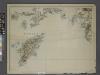
Sheet 14. 1: 250,000. / dressée par Henri Kiepert d'après ses propres observations et d'autres levées pour la plupart inédites = Map of the western part of Asia Minor
From Specialkarte vom westlichen Kleinasien nach seinen eigenen Reisen und anderen grösstenteils noch unveröffentlichten Routenaufnahmen bearbeitet von Heinrich Kiepert = Carte de la partie occidentale de l 'Asie mineure
Insular. Aliquot Aegaei Maris Antiqua Descrip.[:] [Rhodus.] [Karte], in: Theatrum orbis terrarum, S. 517.
1 Karte aus Atlas Ortelius, Abraham Vrients, Jan Baptista
Archipelagi Insularum Aliquot Descrip., [Nicsia] [Karte], in: Theatrum orbis terrarum, S. 246.
1 Karte aus Atlas Ortelius, Abraham
Archipelagi Insularum Aliquot Descrip., [Nicsia] [Karte], in: Theatrum orbis terrarum, S. 341.
1 Karte aus Atlas Ortelius, Abraham Vrients, Jan Baptista
Candia cum Insulis aliquot circa Graeciam[:] [Nicsia] [Karte], in: Gerardi Mercatoris Atlas, sive, Cosmographicae meditationes de fabrica mundi et fabricati figura, S. 493.
1 Karte aus Atlas Mercator, Gerhard Montanus, Petrus
Candia cum Insulis aliquot circa Graeciam[:] [Milo] [Karte], in: Gerardi Mercatoris et I. Hondii Newer Atlas, oder, Grosses Weltbuch, Bd. 2, S. 336.
1 Karte aus Atlas Mercator, Gerhard und Hondius, Jodocus Jansson, Jan
Kos, Nisero and Piscopi (1848)
Archipelago. The Islands of Kos, Nisero and Piscopi, etc.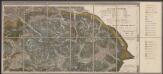
Candia cum Insulis aliquot circa Graeciam[:] [Milo] [Karte], in: Gerardi Mercatoris Atlas, sive, Cosmographicae meditationes de fabrica mundi et fabricati figura, S. 493.
1 Karte aus Atlas Mercator, Gerhard Montanus, Petrus
Candia cum Insulis aliquot circa Graeciam[:] [Nicsia] [Karte], in: Gerardi Mercatoris et I. Hondii Newer Atlas, oder, Grosses Weltbuch, Bd. 2, S. 336.
1 Karte aus Atlas Mercator, Gerhard und Hondius, Jodocus Jansson, Jan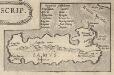
Insular. Aliquot Aegaei Maris Antiqua Descrip.[:] [Samus., Ionica.] [Karte], in: Theatrum orbis terrarum, S. 517.
1 Karte aus Atlas Ortelius, Abraham Vrients, Jan Baptista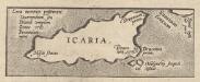
Insular. Aliquot Aegaei Maris Antiqua Descrip.[:] [Icaria.] [Karte], in: Theatrum orbis terrarum, S. 517.
1 Karte aus Atlas Ortelius, Abraham Vrients, Jan Baptista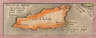
Insular. Aliquot Aegaei Maris Antiqua Descrip.[:] [Icaria.] [Karte], in: Theatrum orbis terrarum, S. 419.
1 Karte aus Atlas Ortelius, Abraham
Candia cum Insulis aliquot circa Graeciam[:] [Santorini.] [Karte], in: Gerardi Mercatoris et I. Hondii Newer Atlas, oder, Grosses Weltbuch, Bd. 2, S. 336.
1 Karte aus Atlas Mercator, Gerhard und Hondius, Jodocus Jansson, Jan
Archipelagi Insularum Aliquot Descrip., [Milo] [Karte], in: Theatrum orbis terrarum, S. 341.
1 Karte aus Atlas Ortelius, Abraham Vrients, Jan Baptista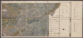
Candia cum Insulis aliquot circa Graeciam[:] [Santorini.] [Karte], in: Gerardi Mercatoris Atlas, sive, Cosmographicae meditationes de fabrica mundi et fabricati figura, S. 493.
1 Karte aus Atlas Mercator, Gerhard Montanus, Petrus