Maps of Karpathos Regional Unit

Candia cum Insulis aliquot circa Graeciam[:] [Scarpanto] [Karte], in: Gerardi Mercatoris et I. Hondii Newer Atlas, oder, Grosses Weltbuch, Bd. 2, S. 336.
1 Karte aus Atlas Mercator, Gerhard und Hondius, Jodocus Jansson, Jan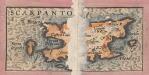
Archipelagi Insularum Aliquot Descrip., [Scarpanto] [Karte], in: Theatrum orbis terrarum, S. 246.
1 Karte aus Atlas Ortelius, Abraham
Candia cum Insulis aliquot circa Graeciam[:] [Scarpanto] [Karte], in: Gerardi Mercatoris Atlas, sive, Cosmographicae meditationes de fabrica mundi et fabricati figura, S. 493.
1 Karte aus Atlas Mercator, Gerhard Montanus, Petrus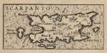
Archipelagi Insularum Aliquot Descrip., [Scarpanto] [Karte], in: Theatrum orbis terrarum, S. 341.
1 Karte aus Atlas Ortelius, Abraham Vrients, Jan Baptista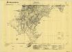
Scarpanto, Mediterranean Sea, Arcassa
Sheet F6 of the six-sheet series: Isola di Scarpanto. Istituto Geografico Militare. Rilievo del 1933. G.S.G.S. 4102. [London] : [War Office]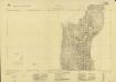
Isola di Scarpanto, Olimbo
Sheet 2 of the six-sheet series: Isola di Scarpanto. Istituto Geografico Militare. Rilievo del 1933. G.S.G.S. 4102. [London] : [War Office]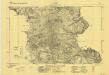
Scarpanto, Mediterranean Sea, Aperi
Sheet F5 of the six-sheet series: Isola di Scarpanto. Istituto Geografico Militare. Rilievo del 1933. G.S.G.S. 4102. [London] : [War Office]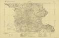
Isola di Scarpanto, Aperi
Sheet 5 of the six-sheet series: Isola di Scarpanto. Istituto Geografico Militare. Rilievo del 1933. G.S.G.S. 4102. [London] : [War Office]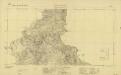
Isola di Scarpanto, Messocorio
Sheet 4 of the six-sheet series: Isola di Scarpanto. Istituto Geografico Militare. Rilievo del 1933. G.S.G.S. 4102. [London] : [War Office]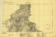
Scarpanto, Mediterranean Sea, Messocorio
Sheet F4 of the six-sheet series: Isola di Scarpanto. Istituto Geografico Militare. Rilievo del 1933. G.S.G.S. 4102. [London] : [War Office]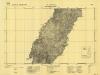
Scarpanto, Mediterranean Sea, M. Cimara
Sheet F3 of the six-sheet series: Isola di Scarpanto. Istituto Geografico Militare. Rilievo del 1933. G.S.G.S. 4102. [London] : [War Office]
Scarpanto, Mediterranean Sea, Olimbo
Sheet F2 of the six-sheet series: Isola di Scarpanto. Istituto Geografico Militare. Rilievo del 1933. G.S.G.S. 4102. [London] : [War Office]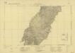
Isola di Scarpanto, M. Cimara
Sheet 3 of the six-sheet series: Isola di Scarpanto. Istituto Geografico Militare. Rilievo del 1933. G.S.G.S. 4102. [London] : [War Office]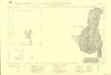
Isola di Scarpanto, Saria
Sheet 1 of the six-sheet series: Isola di Scarpanto. Istituto Geografico Militare. Rilievo del 1933. G.S.G.S. 4102. [London] : [War Office]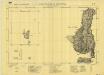
Scarpanto, Mediterranean Sea, Saria
Sheet F1 of the six-sheet series: Isola di Scarpanto. Istituto Geografico Militare. Rilievo del 1933. G.S.G.S. 4102. [London] : [War Office]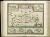
[83][83] Insula Candia ..., uit: Atlas sive Descriptio terrarum orbis
Annotatie: Gedigitaliseerde versie. Amsterdam. Heiloo : Picturae (vervaardiger), 2015. tiff-bestand. Gedigitaliseerd: 07-01-2015; Origineel: Universiteitsbibliotheek Vrije Universiteit (XL.05127.-) ; Netherlands; Titelpagina ontbreekt Wit, Frederik de Amsterdam : Frederick de Wit
Rhodus Ins. [Karte], in: Gerardi Mercatoris Atlas, sive, Cosmographicae meditationes de fabrica mundi et fabricati figura, S. 523.
1 Karte aus Atlas Mercator, Gerhard Montanus, Petrus
Archipelagi Insularum Aliquot Descrip., [Rodus] [Karte], in: Theatrum orbis terrarum, S. 246.
1 Karte aus Atlas Ortelius, Abraham
Archipelagi Insularum Aliquot Descrip., [Rodus] [Karte], in: Theatrum orbis terrarum, S. 341.
1 Karte aus Atlas Ortelius, Abraham Vrients, Jan Baptista
Insular. Aliquot Aegaei Maris Antiqua Descrip.[:] [Rhodus.] [Karte], in: Theatrum orbis terrarum, S. 419.
1 Karte aus Atlas Ortelius, Abraham
Rhodes, DR 47, Cattavia
Rhodes, DR 47. Copied from an Italian map dated 1935. Great Britain. Army. Royal Engineers. Field Survey Company, 512th. [Cairo] : [Survey Directorate, Middle East]
Archipelagi Meridionalis seu Cycladum Insularum accurata Delineatio. [Karte], in: Novus atlas absolutissimus, Bd. 10, S. 234.
1 Karte aus Atlas Janssonius Offizin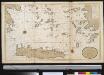
Het zuijderdeel van de Archipel Lagusche Eijlanden int groodt
Greece Gerard van Keulen
Europe 1:1.000.000
1 : 1000000 Kréta (Řecko) Geographical Section, General Staff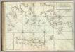
Carte De La Mer Mediterranee. XI.
Roux, Joseph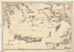
Mittelmeer
1 : 600000 Egejské moře Reichs-Marine-Amt
Iles de L'archipel; Dschezaïr
Nouvel atlas physique politique et historique de l'Empire ottoman et des états limitrophes en Europe, en Asie et en Afrique, en quarante feuilles Hellert, J.J. Bellizard, Dufour et Cie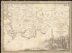
Parte dell'Asia Minore per servire di VI foglio della carta generale dell'Ungheria e della Turchia Europea
1 : 1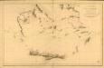
Carte réduite de la partie Méridionale de l’Archipel
Carte réduite de la partie Méridionale de l'Archipel, rédigée d'après les travaux exécutées dans les années 1818 & 1819 par M. Gauttier. [Paris] : Dépôt Général de la Marine
![Candia cum Insulis aliquot circa Graeciam[:] [Scarpanto] [Karte], in: Gerardi Mercatoris et I. Hondii Newer Atlas, oder, Grosses Weltbuch, Bd. 2, S. 336.](https://images-2.georeferencer.com/images/iiif/121484811674/full/,300/0/native.jpg)

