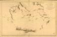
Maps of Rhodes Regional Unit
Sheet 14. 1: 250,000. / dressée par Henri Kiepert d'après ses propres observations et d'autres levées pour la plupart inédites = Map of the western part of Asia Minor
From Specialkarte vom westlichen Kleinasien nach seinen eigenen Reisen und anderen grösstenteils noch unveröffentlichten Routenaufnahmen bearbeitet von Heinrich Kiepert = Carte de la partie occidentale de l 'Asie mineure
Archipelagi Insularum Aliquot Descrip., [Rodus] [Karte], in: Theatrum orbis terrarum, S. 246.
1 Karte aus Atlas Ortelius, Abraham
Rhodus Ins. [Karte], in: Gerardi Mercatoris Atlas, sive, Cosmographicae meditationes de fabrica mundi et fabricati figura, S. 523.
1 Karte aus Atlas Mercator, Gerhard Montanus, Petrus
Archipelagi Insularum Aliquot Descrip., [Rodus] [Karte], in: Theatrum orbis terrarum, S. 341.
1 Karte aus Atlas Ortelius, Abraham Vrients, Jan Baptista
Insular. Aliquot Aegaei Maris Antiqua Descrip.[:] [Rhodus.] [Karte], in: Theatrum orbis terrarum, S. 419.
1 Karte aus Atlas Ortelius, Abraham
Insular. Aliquot Aegaei Maris Antiqua Descrip.[:] [Rhodus.] [Karte], in: Theatrum orbis terrarum, S. 517.
1 Karte aus Atlas Ortelius, Abraham Vrients, Jan Baptista
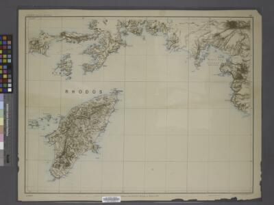
Carta topografica dell'isola di Rodi
1 : 25000 Rhodos, ostrov (Řecko) Istituto geografico militare
Rhodes, DR 47, Monolito
Rhodes, DR 47.Copied from an Italian map dated 1935. Great Britain. Army. Royal Engineers. Field Survey Company, 512th. [Cairo] : [Survey Directorate, Middle East]
Rhodes, DR 47, Lardo
Rhodes, DR 47. Copied from an Italian map dated 1935. Great Britain. Army. Royal Engineers. Field Survey Company, 512th. [Cairo] : [Survey Directorate, Middle East]
Rhodes, DR 47, Salaco
Rhodes, DR 47. Copied from an Italian map dated 1935. Great Britain. Army. Royal Engineers. Field Survey Company, 512th. [Cairo] : [Survey Directorate, Middle East]
Rhodes, DR 47, Castello
Rhodes, DR 47. Copied from an Italian map dated 1935. Great Britain. Army. Royal Engineers. Field Survey Company, 512th. [Cairo] : [Survey Directorate, Middle East]
Rhodes, DR 47, Monte Attario
Rhodes, DR 47. Copied from an Italian map dated 1935. Great Britain. Army. Royal Engineers. Field Survey Company, 512th. [Cairo] : [Survey Directorate, Middle East]
Rhodes, DR 47, Trianda
Rhodes, DR 47. Copied from an Italian map dated 1935. Great Britain. Army. Royal Engineers. Field Survey Company, 512th. [Cairo] : [Survey Directorate, Middle East]
Rhodes, DR 47, Afando
Rhodes, DR 47. Copied from an Italian map dated 1935. Great Britain. Army. Royal Engineers. Field Survey Company, 512th. [Cairo] : [Survey Directorate, Middle East]
Rhodes, DR 47, Alaerma
Rhodes, DR 47.Copied from an Italian map dated 1935. Great Britain. Army. Royal Engineers. Field Survey Company, 512th. [Cairo] : [Survey Directorate, Middle East]
Rhodes, DR 47, Apollona
Rhodes, DR 47. Copied from an Italian map dated 1935. Great Britain. Army. Royal Engineers. Field Survey Company, 512th. [Cairo] : [Survey Directorate, Middle East]
Rhodes, DR 47, Malona
Rhodes, DR 47. Copied from an Italian map dated 1935. Great Britain. Army. Royal Engineers. Field Survey Company, 512th. [Cairo] : [Survey Directorate, Middle East]
Rhodes, DR 47, Cattavia
Rhodes, DR 47. Copied from an Italian map dated 1935. Great Britain. Army. Royal Engineers. Field Survey Company, 512th. [Cairo] : [Survey Directorate, Middle East]
Rhodes, DR 47, Lacania
Rhodes, DR 47. Copied from an Italian map dated 1935. Great Britain. Army. Royal Engineers. Field Survey Company, 512th. [Cairo] : [Survey Directorate, Middle East]
Rhodes, DR 47, Villanova
Rhodes, DR 47. Copied from an Italian map dated 1935. Great Britain. Army. Royal Engineers. Field Survey Company, 512th. [Cairo] : [Survey Directorate, Middle East]
Siége de Rhodes par Souleiman I
Nouvel atlas physique politique et historique de l'Empire ottoman et des états limitrophes en Europe, en Asie et en Afrique, en quarante feuilles Hellert, J.J. Bellizard, Dufour et Cie
Isola Di Piscopi, Dodecanese Islands 1:25,000 (1953)
Sheet 24 of the 53-sheet series: Dodecanese Islands 1:25,000, A.M.S. Series M801. Relief shown by contours, spot heights and rock drawings. Contour interval: 10 m. United States. Army. Corps of Engineers Washington, D.C. : Army Map Service, Corps of Engineers, U.S. Army.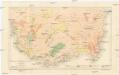
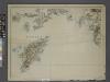
Geologische Übersichtskarte von Lykien
1 : 300000 Lýkie Tietze, Emil Ernst August Alfred Hölder
Carta dell’isola di Coo (Kos) (Sheet 2)
This map series - Carta dell'isola di Coo (Kos), Series GSGS 4103 - provides coverage of the Greek island of Coo [Kos] in five sheets. The map content was copied directly from Italian maps that were surveyed in 1925. Great Britain. War Office. General Staff. Geographical Section. [London] : War Office
Kos, Nisero and Piscopi (1848)
Archipelago. The Islands of Kos, Nisero and Piscopi, etc.
90. Anatolia occidentale, Isole Egee.
1 : 1500000 Touring club italiano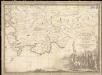
Parte dell'Asia Minore per servire di VI foglio della carta generale dell'Ungheria e della Turchia Europea
1 : 1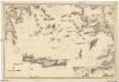
Mittelmeer
1 : 600000 Egejské moře Reichs-Marine-Amt
[Die Balkan-Halbinsel, Blatt 4]
Adolf Stieler's Handatlas über alle Theile der Erde und über das Weltgebäude Stieler, Adolf Justus Perthes