Maps of Czech Republic
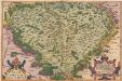
Regni Bohemiae Descriptio. [Karte], in: Theatrum orbis terrarum, S. 156.
1 Karte aus Atlas Ortelius, Abraham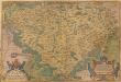
Regni Bohemiae Descriptio. [Karte], in: Theatrum orbis terrarum, S. 63.
1 Karte aus Atlas Ortelius, Abraham
Regni Bohemiae Nova descriptio
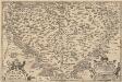
Regni Bohemiae Descriptio. [Karte], in: Theatrum orbis terrarum, S. 248.
1 Karte aus Atlas Ortelius, Abraham Vrients, Jan Baptista
Bohemia

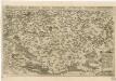
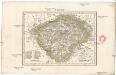
Regni Bohemiae Descriptio
Chogragraphia Insignis Regni Bohemiae

Kreis-, Gerichts-, Völker-, Telegrafen-, Eisenbahn- und Post- Karte des Königreiches Böhmen
1 : 950000 Česko Raffelsperger, Franz Graben
Charte von Boehmen
1 : 1000000 Česko Kipferling, Karl Joseph in J. Riedl's Kunsthandlung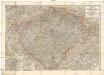
Hölzelova generální mapa Království českého
Čechy (Česko) Wagner, Jan Eduard Lepař, Zdeněk v geografickém závodě Ed. Hölzela
Regni Bohemiae Descriptio

Special-Karte des Königreiches Boehmen
1 : 890000 Česko
Charte von Boehmen
1 : 1000000 Čechy (Česko) Kipferling, Karl Joseph Schönberg, Johann Johann Schönberg
Charte von Boehmen
1 : 1000000 Čechy (Česko) Kipferling, Karl Joseph Schönberg, Johann Johann Schönberg
Charte von Boehmen
1 : 1000000 Čechy (Česko) Kipferling, Karl Joseph im Verlage des Kunst u. Industrie Comptoirs
Geognostische Karte des Königsreichs Böhmen
1 : 1020000 Čechy (Česko) Preininger, Andreas Biller, Dominicus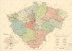
Mapa krajského rozdělení Čech r. 1654 na podkladě územní organisace soudních okresů r. 1946

Karte des Königreiches Boehmen
1 : 880000 Čechy (Česko) Raffelsperger, Franz Rumpold, F. im Typographischen Landkarten-Verlage
Charte der älteren und neueren Bergbaue in Böhmen
1 : 960000 Česko Hamernik, J.
Karte vom Königreiche Böhmen
1 : 690000 Česko Carl Wilhelm Medau
Karte vom Königreiche Böhmen
1 : 690000 Česko Carl Wilhelm Medau
Bohemia [Karte], in: Le théâtre du monde, ou, Nouvel atlas contenant les chartes et descriptions de tous les païs de la terre, Bd. 1, S. 204.
1 Karte aus Atlas Blaeu, Willem Janszoon und Blaeu, Joan Blaeu, Willem Janszoon
Special-Karte des Königreiches Böhmen

Schulkarte von Böhmen

Karte fon Königreiche Böhmen...

Mapa Čech
1 : 500000
Charte von Boehmen

Bez titulu: Statistické mapky Čech
Čechy
1 : 2775000 Čechy (Česko)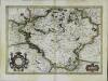
Bohemia
1 Karte : Kupferdruck ; 33 x 48 cm Mercator; Hondius Henricus Hondius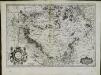
![Regni Bohemiae Descriptio. [Karte], in: Theatrum orbis terrarum, S. 156.](https://images-2.georeferencer.com/images/iiif/696904853752/full/,300/0/native.jpg)

