Maps of Normandy

Ooster-deel Van 'T Canaal [Karte], in: De Nieuwe Groote Vermeerderde Zee-Atlas ofte Water-Werelt, S. 43.
1 Karte aus Atlas Doncker, Hendrick
Le Duché et gouvernement de Normandie
1 Karte : Kupferdruck ; 47 x 59 cm Jaillot chez J. Cóvens et C. Mortier
Le Duché et gouvernement de Normandie
1 Karte : Kupferdruck ; 47 x 59 cm Jaillot A.-H. Jaillot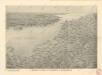
Reliefkarte des Kanals von Cherbourg bis zur Scheldemündung mit Südost - England und Nordfrankreich

La plus grande partie de La Manche, qui contient les côtes d'Angleterre et celles de France les bords maritimes de Picardie
1 : 650000 Anglie Lotter, Tobias Conrad Tob. Conr. Lotter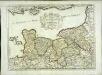
Duché et gouvernement de Normandie
1 Karte : Kupferdruck ; 37 x 50 cm Sanson; Cordier s.n.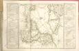
Het oostelijkste gedeelte vant Kanaal vertoonende de kust van Engeland van Dover tot Portland
England Gerard van Keulen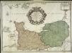
Le gouvernement general de Normandie
1 Karte : Kupferdruck ; 45 x 63 cm Desnos chez Desnos géographe ingénieur pour les globes spheres et instruments de mathématique rue St. Jacques au globe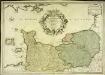
Le gouvernement general de Normandie
1 Karte : Kupferdruck ; 45 x 65 cm Fer; Danet; Starckman chez Danet gendre de l'auteur sur le pont Notre Dame a la Sphere royale
La plus grande partie de la Manche
1 Karte : Kupferdruck ; 47 x 55 cm Lotter aux depens de Tob: Conr: Lotter geogr
La plus grande partie de la Manche
1 Karte : Kupferdruck ; 48 x 56 cm Seutter aux depens de Matthieu Seutter
La plus grande partie de la Manche
1 Karte : Kupferdruck ; 45 x 58 cm Ottens; Ottens chez R. et J. Ottens

Charte von England und Wallis, 4
1 Blatt : 62 x 53 cm Walch
Karte von England und Wallis, 4
1 Blatt : 62 x 53 cm Schrämbl
Duche et gouvernement general de Normandie
1 Karte : Kupferdruck ; 49 x 58 cm Seutter; Lotter M. Seutter
Duche et gouvernement general de Normandie
1 Karte : Kupferdruck ; 48 x 59 cm Wit se vend chez J. Cóvens et C. Mortier
Duche et gouvernement general de Normandie
1 Karte : Kupferdruck ; 48 x 59 cm Wit F. de Wit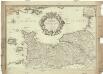
Le gouvernement general de Normandie, divisé en Haute et Basse
1 : 600000 Normandie (Francie) Fer, Nicolas de Danet, Guillaume Danet
Normandia ducatus
1 Karte : Kupferdruck ; 37 x 51 cm Janssonius Joannes Janssonius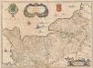
Normandia Ducatus. [Karte], in: Novus atlas absolutissimus, Bd. 4, S. 109.
1 Karte aus Atlas Janssonius Offizin
Normandia Ducatus. [Karte], in: Gerardi Mercatoris et I. Hondii Newer Atlas, oder, Grosses Weltbuch, Bd. 2, S. 65.
1 Karte aus Atlas Mercator, Gerhard und Hondius, Jodocus Jansson, Jan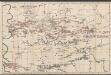
Le Duché et Gouvernement De Normandie divisée en Haute et Basse Normandie [...] [Karte], in: Atlas nouveau, contenant toutes les parties du monde [...], Bd. 1, S. 117.
1 Karte aus Atlas Sanson, Nicolas Jaillot, Alexis Hubert und Mortier, Pieter
Duché et gouvernement general de Normandie, divise en haut et bas en divers pays et balliages avec le gouvernement general de Havre de Grace
1 : 450000 par F. de Witt A Amsterdam : [F. de Wit]
Carte de France, 2
2 Blätter : Kupferdruck ; 53 x 45 cm Crepy
Gouvernement général de Normandie
1 Karte : Kupferdruck ; 47 x 57 cm Robert de Vaugondy G. et D. Robert de Vaugondy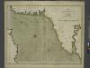
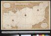
The sea-coasts of FRANCE from Calais to the River Seine
from The sea-atlas : containing an hydrographical description of most of the sea-coasts of the known parts of the world.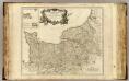
Normandie.
1 : 550000 Robert de Vaugondy, Gilles, 1688-1766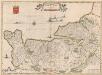
![Ooster-deel Van 'T Canaal [Karte], in: De Nieuwe Groote Vermeerderde Zee-Atlas ofte Water-Werelt, S. 43.](https://images-2.georeferencer.com/images/iiif/481955849544/full/,300/0/native.jpg)

