Maps of Upper Normandy
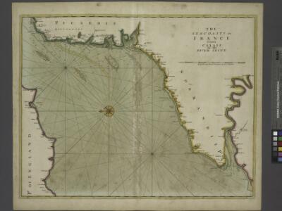
The sea-coasts of FRANCE from Calais to the River Seine
from The sea-atlas : containing an hydrographical description of most of the sea-coasts of the known parts of the world.
delineation of the strata of England and Wales, with part of Scotland
1 : 320000 Blatt 14 Smith, William Cary
Het oostelijkste gedeelte vant Kanaal vertoonende de kust van Engeland van Dover tot Portland
England Gerard van Keulen
Normandie.
1 : 550000 Robert de Vaugondy, Gilles, 1688-1766
3) II.O. ''Boulogne'', uit: Carte géologique de France
1 : 500000 Annotatie: Voor aanwezige bladen zie bladoverzicht [S.l : s.n.]
Le Pais De Caux [Karte], in: Novus atlas absolutissimus, Bd. 4, S. 112.
1 Karte aus Atlas Janssonius Offizin
LE PAYS | DE CAVX
[Amsterdam : Joan Blaeu]
A new travelling map of the country round London, 4
1 Blatt : 49 x 60 cm J. Andrews & A. Drury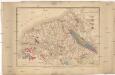
Carte géologique du département de la Seine-inférieure et des parties limitrophes des départements voisins
1 : 218500 Passy, M. A. Noel, M.
Carte Particuliere des Environs d'Arthois du Boulenois et d'une Partie de la Picardie
1 : 250000 Mollova mapová sbírka Seutter, Matthäus Lotter, Tobias Conrad Seutter, Matthäus
Le pais de Cavx
1 Karte : Kupferdruck ; 36 x 48 cm Mercator; Hondius; Tavernier imprimé chez Henrÿ Hondius, ches Melchior Tavernier aupres du Palais
Carte de la Picardie, Artois, Boulonois, Flandre françoise, Haynaut et Cambresis, 1
2 Blätter : 62 x 43 cm Bourgoin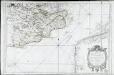
Carte du comté de Kent et du pas de Calais
1 Karte : Kupferdruck ; 55 x 82 cm Bellin s.n.
Carte de la province de Normandie, 2
1 Blatt : Esnauts et Rapilly
Le gouvernement general de Normandie, 2
1 Blatt : chez l'auteur Jaillot
Generalkarte von Zentraleuropa

9) V.N.O. ''Le Havre'', uit: Carte géologique de France
1 : 500000 Annotatie: Voor aanwezige bladen zie bladoverzicht [S.l : s.n.]
Sheet 12 England, South East & London, uit: Maps of England & Wales : scale 4 miles to 1 inch / Ordnance Survey
1 : 253440 titelvariant: Maps of England and Wales; Annotatie: Titel op cassette; Met bladoverzicht op de achterzijde van de cassette; Annotatie geografische gegevens: Hoogtelijneninterval 200 ft Ordnance Survey, United Kingdom Southampton : Ordnance Survey Office
England and Wales[OS civil air edition]
Ordnance Survey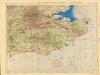
Ordnance Survey of England and Wales (Aeronautical map)
Great Britain. War Office. General Staff. Geographical Section [London] : [Air Ministry],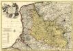
Le Comté d'Artois, et des Environs, ou l'on voit le Ressort du Conseil Provincial d'Artois avec les Frontieres de Picardie
1 : 250000 Mollova mapová sbírka Visscher, Nicolaes Schenk, Pieter Visscher, Nicolaus I.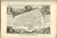

Dept. De La Siene Inferieure.
1 : 450000 Levasseur, Victor.
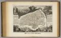
Département de la Seine inférieure
1 Karte : Kupferdruck ; 48 x 48 cm Houdan au bureau de l'atlas national de France rue Serpente n.o 15, et au cabient bibliographique rue de la Monnoye n.o 5
Sheets 17-18. (Cary's England, Wales, and Scotland).
1 : 360000 Cary, John, ca. 1754-1835
Een gedeelte van het Kanaal van de Hoofden tot den hoek van Bevesier als meede een gedeelte van de cust van Vrankrijk
English Channel Gerard van Keulen
Sheets 7-8. (Cary's England, Wales, and Scotland).
1 : 360000 Cary, John, ca. 1754-1835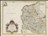
Oromansaci, et Gesoriacus Pagus in Morinis, evesché de Boulogne ou sont les Comté et seneschaussée de Boulenois : Balliage de Calais dans le Pays Reconquis : Souveraineté d'Ardres, etc.
1 : 211000