Maps of Poland
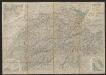
Polonia Et Silesia [Karte], in: Gerardi Mercatoris et I. Hondii Newer Atlas, oder, Grosses Weltbuch, Bd. 1, S. 340.
1 Karte aus Atlas Mercator, Gerhard und Hondius, Jodocus Jansson, Jan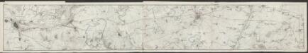
Polonia Et Silesia [Karte], in: Gerardi Mercatoris Atlas, sive, Cosmographicae meditationes de fabrica mundi et fabricati figura, S. 409.
1 Karte aus Atlas Mercator, Gerhard Montanus, Petrus
Polonia Regnum, et Silesia Ducatus. [Karte], in: Theatrum orbis terrarum, sive, Atlas novus, Bd. 1, S. 102.
1 Karte aus Atlas Blaeu, Joan Blaeu, Willem Janszoon
Partie, l'Allemagne. Europe 14.
1 : 1641836 Vandermaelen, Philippe, 1795-1869
Polonia Regnum, et Silesia Ducatus. [Karte], in: Novus Atlas, das ist, Weltbeschreibung, Bd. 1, S. 73.
1 Karte aus Atlas Blaeu, Joan Blaeu, Willem Janszoon
Polonia Regnum, et Silesia Ducatus. [Karte], in: Le théâtre du monde, ou, Nouvel atlas contenant les chartes et descriptions de tous les païs de la terre, Bd. 1, S. 94.
1 Karte aus Atlas Blaeu, Willem Janszoon und Blaeu, Joan Blaeu, Willem Janszoon
Polonia regnvm
Polsko Bouttats, Gaspar
Polonia et Silesia
1 Karte : Kupferdruck ; 33 x 44 cm Mercator; Hondius Henricus Hondius
Polonia et Silesia
1 Karte : Kupferdruck ; 33 x 44 cm Mercator s.n.
Mapa gęstości zaludnienia Polski
1 : 3000000 Polsko Lencewicz, Stanisław Uniwersytet Warszawski
POLONIA | Regnum, et | SILESIA | Ducatus.
Guiljelmus | Blaeu excudit.
Lidová republika polská

87-88. Poland. The World Atlas.
1 : 1500000 USSR (Union of Soviet Socialist Republics).
Mapa samochodowa Polski

Novissima Poloniae Regni Descriptio. [Karte], in: Novus atlas absolutissimus, Bd. 1, S. 90.
1 Karte aus Atlas Janssonius Offizin

Polen und Preussen 1240 - 1386
1 : 6000000 Polen, Preußen (Ordensstaat)
Polen und Preussen 1140 - 1240
1 : 6000000 Polen, Preußen (Ordensstaat)
Polsko, Prusy, Poznáňsko [sic]
1 : 3890000 Polsko
Herzogthum Warschau
1 : 2310000 Varšava (Polsko : oblast)
Polonia Regnum, et Silesia Ducatus
1 : 1600000 Mollova mapová sbírka Blaeu, Willem Janszoon Bleau, Willem Janszon
Novissima Poloniae regni Descriptio
1 : 1600000 Mollova mapová sbírka Janssonius, Johannes Janssonius, Johannes I
III. vojenské mapování 3959
1 : 75000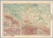
Poland - South. Pergamon World Atlas.
1 : 1250000 Polish Army Topography Service
Geschichtl. Entwicklung des Königr. Preussen bis zum Frieden von Tilsit (1807)
Preußen, Polen, Tilsit / Friede

Zachodnie granice Polski
Polen Deutschland Deutsches Reich Grenze Wierzbicki, B.
Germany, eastern border regions surface configuration
Relief shown by gradient tints. Includes most of western Poland. Includes location map. United States. Office of Strategic Services. Research and Analysis Branch. [Washington, D.C.] : R & A, OSS
![Polonia Et Silesia [Karte], in: Gerardi Mercatoris et I. Hondii Newer Atlas, oder, Grosses Weltbuch, Bd. 1, S. 340.](https://images-2.georeferencer.com/images/iiif/806527595685/full/,300/0/native.jpg)

