Maps of Poland

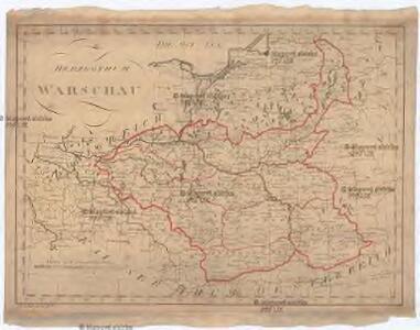
Herzogthum Warschau
1 : 2310000 Varšava (Polsko : oblast)
Polonia Et Silesia [Karte], in: Gerardi Mercatoris Atlas, sive, Cosmographicae meditationes de fabrica mundi et fabricati figura, S. 409.
1 Karte aus Atlas Mercator, Gerhard Montanus, Petrus
Polonia et Silesia
1 Karte : Kupferdruck ; 33 x 44 cm Mercator; Hondius Henricus Hondius
Polonia et Silesia
1 Karte : Kupferdruck ; 33 x 44 cm Mercator s.n.

POLONIA | Regnum, et | SILESIA | Ducatus.
Guiljelmus | Blaeu excudit.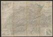
Polonia Et Silesia [Karte], in: Gerardi Mercatoris et I. Hondii Newer Atlas, oder, Grosses Weltbuch, Bd. 1, S. 340.
1 Karte aus Atlas Mercator, Gerhard und Hondius, Jodocus Jansson, Jan
Lidová republika polská
Polonia Regnum, et Silesia Ducatus. [Karte], in: Theatrum orbis terrarum, sive, Atlas novus, Bd. 1, S. 102.
1 Karte aus Atlas Blaeu, Joan Blaeu, Willem Janszoon
Mapa samochodowa Polski
Polonia Regnum, et Silesia Ducatus. [Karte], in: Le théâtre du monde, ou, Nouvel atlas contenant les chartes et descriptions de tous les païs de la terre, Bd. 1, S. 94.
1 Karte aus Atlas Blaeu, Willem Janszoon und Blaeu, Joan Blaeu, Willem Janszoon
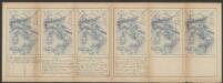
Partie, l'Allemagne. Europe 14.
1 : 1641836 Vandermaelen, Philippe, 1795-1869
Polonia Regnum, et Silesia Ducatus. [Karte], in: Novus Atlas, das ist, Weltbeschreibung, Bd. 1, S. 73.
1 Karte aus Atlas Blaeu, Joan Blaeu, Willem Janszoon
Novissima Poloniae regni Descriptio
1 : 1600000 Mollova mapová sbírka Janssonius, Johannes Janssonius, Johannes I
Mapa gęstości zaludnienia Polski
1 : 3000000 Polsko Lencewicz, Stanisław Uniwersytet Warszawski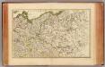
L'Alemagne 2.
1 : 1800000 Rizzi Zannoni, Giovanni Antonio Bartolomeo, 1736-1814
Polonia regnvm
Polsko Bouttats, Gaspar
Charte vom Königreiche Preussen dem Herzogthume Warschau und dem neuen Danziger Gebiethe
1 : 1510000 Gdaňsk-oblast (Polsko) Soltzmann, D. F. Geographischen Instituts

Polonia Regnum, et Silesia Ducatus
1 : 1600000 Mollova mapová sbírka Blaeu, Willem Janszoon Bleau, Willem Janszon
Polonia Propria
1 : 1400000 Mollova mapová sbírka Homann, Johann Baptist Homann, Johann Baptista - dědici
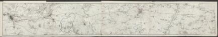
Karte vom Herzogthum Warschau, und den angrenzenden Staaten in IV Sectionen
1 : 650000 Polsko Engelhardt, Friedrich Bernhard Mare, Carl Simon Schropp & Comp.
TABULA NOVA POLONIAE et SILESIAE
1 : 1800000 Gdaňsk (Polsko) Goos, Abraham impreßa in aedibus Nicolaij Iohannis Vißcher
Generalkarte vom Königreich Preussen
1 : 1200000 Polsko Sotzmann, Daniel Friedrich Schneider u. Weiglischen Kunst und Buchhandlung
Generalkarte vom Königreich Preussen
1 : 1200000 Polsko Sotzmann, Daniel Friedrich Schneider u. Weiglischen Kunst und Buchhandlung

Die preusischen Provinzen Preussen und Posen und dan Königreich Polen
1 : 1220000 Polsko Gräf, C. Dellinger Geographisches Institut
Preussen und Polen
Schul-Atlas in 36 Karten Völter, Daniel Verlag der J.M. Dannheimer'schen Buchhandlung
Karte von den königl. preussischen Provinzen Preussen und Posen nebst dem kaiserlich russischen Königreiche Polen und dem Gebiete der freien Stadt Krakau
1 : 1370000 Gdaňsk (Polsko) Weiland, Karl Ferdinand Geogr. Institut
Karte von den königl. preussischen Provinzen Preussen und Posen nebst dem kaiserlich russischen Königreiche Polen und dem Gebiete der freien Stadt Krakau
1 : 1370000 Gdaňsk (Polsko) Weiland, Karl Ferdinand Mädel, J. im Verlage des geogr. Instituts
Karte von den Königl. Preussischen Provinzen Preussen und Posen nebst dem Kaiserlich Russischen Königreiche Polen und dem Gebiete der freien Stadt Krakau
1 : 1370000 Gdaňsk (Polsko) Weiland, Karl Ferdinand Mädel, J. Verlage des geogr. Instituts