Maps of Poland

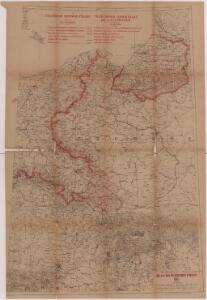
Zachodnie granice Polski
Polen Deutschland Deutsches Reich Grenze Wierzbicki, B.
Germany, E. sheet.
1 : 1400000 Rand McNally and Company
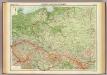
Poland, 1:2,000,000
1 : 2000000
Polen u. Nachbarländer 963 bis 992
1 : 12000000 Polen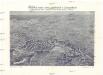
Plastická mapa zemí Sudetských a Karpatských
Evropa střední E. Šolc
Kaart van het oostelijk front
1 : 1900000 [S.l. : s.n.]
Polen unter Boleslaw Chrobry und bis 1139
1 : 12000000 Polen Bolesław I., Polen, König
Germany. Deutschland II.
1 : 1760000 Society for the Diffusion of Useful Knowledge (Great Britain)
Nr. 18b. Hindenburgs Züge
Polen Weltkrieg <1914-1918>, Ostfront
Geschichtl. Entwicklung des Königr. Preussen bis zum Frieden von Tilsit (1807)
Preußen, Polen, Tilsit / Friede
III. vojenské mapování 3959
1 : 75000
Polen und Preussen 1240 - 1386
1 : 6000000 Polen, Preußen (Ordensstaat)
Polsko, Prusy, Poznáňsko [sic]
1 : 3890000 Polsko

Preussischer Staat.
1 : 2800000 Flemming, Carl
Polen und Preussen 1140 - 1240
1 : 6000000 Polen, Preußen (Ordensstaat)
Sbírka map a diagramů použitých na mírových konferencích v Paříži v letech 1919 - 1920

Germany, eastern border regions surface configuration
Relief shown by gradient tints. Includes most of western Poland. Includes location map. United States. Office of Strategic Services. Research and Analysis Branch. [Washington, D.C.] : R & A, OSS
Carte de la monarchie prussienne, a l'orient du Weser
1 : 2300000 Prusko Mentelle, Edme Tardieu, Pierre François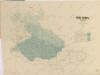
Mapa historického vývoje Československého státu (od XIV. do XIX. století)
Poland & Czecho-Slovakia.
1 : 2000000 John Bartholomew and Son
Superficie de petites exploitations privées (au-dessous de 50 ha) en proportions pour cent de la superficie générale
1 : 5000000 Polsko w Biurze kartograficznem
German Empire 2.
1 : 1774080 Letts, Son & Co.
Germany (Deutschland)
1 : 1760000 Polsko Walker, C. Baldwin & Cradock
Prussia.
1 : 4118400 Lucas, Fielding Jr.
Prussia And Saxony.
1 : 2661120 Colton, G.W.
Mapa gęstości zaludnienia Polski
1 : 3000000 Polsko Lencewicz, Stanisław Uniwersytet Warszawski
Germany, eastern border regions : administrative divisions
1 : 2570000 Inset: Major administrative divisions. "July 1, 1944, information is shown within the 1937 Germany boundary only." "No. 6275." United States. Office of Strategic Services. Research and Analysis Branch. [Washington, D.C.] : R & A, OSS
Czechoslovakia.
From Czechoslovakia