Maps of Stendal

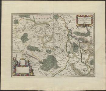
MARCHIONATUS | BRANDENBURGICI | PARS, quæ | MARCHIA VETUS, | Vulgo | ALTEMARCK, | dicitur.
[Amsterdam : Joan Blaeu]

Magdebvrgensis Archiepiscopatvs
1 : 350000 Mollova mapová sbírka Blaeu, Joan Blaeu, Joan I.

75. Stendal, uit: Topographische Uebersichtskarte des Deutschen Reiches / herausgegeben v. d. Kartogr. Abt. d. Königl. Preuß. Landesaufnahme
1 : 200000 titelvariant: Topogr. Übersichtskarte des Deutschen Reiches; Annotatie: Titel boven bladen ook: Topogr. Übersichtskarte des Deutschen Reiches; Annotatie geografische gegevens: Op elk blad twee maatstokken: 10 Kilometer = 5,5 cm; 1 geogr. Meile = 3,6 cm; Legenda onder op elk blad Königlich Preußische Landesaufnahme. Kartographische Abtheilung [S.l : Königlich Preußische Landesaufnahme, Kartographische Abtheilung]
Wittenberge 46, uit: Special-Karte von Mittel-Europa / nach amtlichen Quellen bearbeitet von W. Liebenow
1 : 300000 titelvariant: W. Liebenow's Mittel-Europa; Annotatie: Titel boven de bladen: W. Liebenow's Mittel-Europa Johannes Wilhelm Liebenow 1822-1897 Frankfurt a. M. : Ludwig Ravenstein
241. Havelberg.
1 : 100000 Reichsamt fur Landesaufnahme
265. Gardelegen.
1 : 100000 Reichsamt fur Landesaufnahme
Composite: 265. Gardelegen.
1 : 100000 Reichsamt fur Landesaufnahme
74. Salzwedel, uit: Topographische Uebersichtskarte des Deutschen Reiches / herausgegeben v. d. Kartogr. Abt. d. Königl. Preuß. Landesaufnahme
1 : 200000 titelvariant: Topogr. Übersichtskarte des Deutschen Reiches; Annotatie: Titel boven bladen ook: Topogr. Übersichtskarte des Deutschen Reiches; Annotatie geografische gegevens: Op elk blad twee maatstokken: 10 Kilometer = 5,5 cm; 1 geogr. Meile = 3,6 cm; Legenda onder op elk blad Königlich Preußische Landesaufnahme. Kartographische Abtheilung [S.l : Königlich Preußische Landesaufnahme, Kartographische Abtheilung]
264. Klotze.
1 : 100000 Reichsamt fur Landesaufnahme
239. Salzwedel.
1 : 100000 Reichsamt fur Landesaufnahme
266. Stendal.
1 : 100000 Reichsamt fur Landesaufnahme
Composite: 266. Stendal.
1 : 100000 Reichsamt fur Landesaufnahme
240. Seehausen.
1 : 100000 Reichsamt fur Landesaufnahme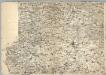
Composite: 239. Salzwedel.
1 : 100000 Reichsamt fur Landesaufnahme
290. Neuhaldensleben.
1 : 100000 Reichsamt fur Landesaufnahme
Composite: 240. Seehausen.
1 : 100000 Reichsamt fur Landesaufnahme
Composite: 241. Havelberg.
1 : 100000 Reichsamt fur Landesaufnahme
291. Burg a. d. Ihle.
1 : 100000 Reichsamt fur Landesaufnahme
Composite: 291. Burg a. d. Ihle.
1 : 100000 Reichsamt fur Landesaufnahme
289. Oebisfelde.
1 : 100000 Reichsamt fur Landesaufnahme
Meßtischblatt 1970 : Gr. Wusterwitz, 1936
1 : 250000 Gr. Wusterwitz. - Hrsg. 1883, einz. Nachtr. 1936. - 1:25000. - [Berlin]: Reichsamt für Landesaufnahme, 1936. - 1 Kt.
Meßtischblatt 3639 : Karow, 1939
1 : 250000 Karow. - Hrsg. 1901. - 1:25000. - [Berlin]: Reichsamt für Landesaufnahme, 1939. - 1 Kt.
Meßtischblatt 1969 : Karow bei Genthin, 1912
1 : 250000 Karow bei Genthin. - Aufn. 1880, hrsg. 1882, gedr. [19]12. - 1:25000. - [Berlin]: Reichsamt für Landesaufnahme, 1912. - 1 Kt.
Meßtischblatt 3638 : Parchen, 1953
1 : 250000 Parchen. - Hrsg. 1882, Ausg. 1932. - 1:25000. - [Berlin]: MdI, 1953. - 1 Kt.
Meßtischblatt 1968 : Parchen, 1919
1 : 250000 Parchen. - Aufn. 1880, Nachtr. 1919. - 1:25000. - [Berlin]: Reichsamt für Landesaufnahme, 1919. - 1 Kt.
Meßtischblatt 3637 : Parey, 1952
1 : 250000 Parey. - Hrsg. 1882, Ausg. 1932. - 1:25000. - [Berlin]: MdI, 1952. - 1 Kt.