Maps of Salzwedel
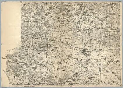
Composite: 239. Salzwedel.
1 : 100000 Reichsamt fur Landesaufnahme
239. Salzwedel.
1 : 100000 Reichsamt fur Landesaufnahme
Meßtischblatt 3132 : Salzwedel, 1955
1 : 250000 Salzwedel. - Hrsg. 1902, Ausg. 1932, Nachdr. 1955. - 1:25000. - [Berlin]: MdI, 1955. - 1 Kt.
Messtischblatt 1609 : Salzwedel, 1902 Salzwedel
1 : 250000 Salzwedel. - Aufn. 1900. - 1:25000. - [Berlin]: Reichsamt für Landesaufnahme, 1902. - 1 Kt.
Messtischblatt 1609 : Salzwedel, 1873 Salzwedel
1 : 250000 Salzwedel. - Aufn. 1859. - 1:25000. - [Berlin]: Reichsamt für Landesaufnahme, 1873. - 1 Kt.
Messtischblatt 1608 : Bergen a. d. Dumme, 1902 Bergen
1 : 250000 Bergen. - Aufn. 1879/1900, hrsg. 1902. - 1:25000. - [Berlin]: Reichsamt für Landesaufnahme, 1902. - 1 Kt.
Meßtischblatt 1677 : Waddekath, 1873
1 : 250000 Waddekath. - Aufn. 1859. - 1:25000. - [Berlin]: Reichsamt für Landesaufnahme, 1873. - 1 Kt.
Meßtischblatt 1537 : Clenze, 1881
1 : 250000 Klenze. - Aufn. 1879, hrsg. 1881. - 1:25000. - [Berlin]: Reichsamt für Landesaufnahme, 1881. - 1 Kt.
Meßtischblatt 3032 : Lüchow, 1939
1 : 250000 Lüchow. - Hrsg. 1881, einz. Nachtr. 1939. - 1:25000. - [Berlin]: Reichsamt für Landesaufnahme, 1939. - 1 Kt.
Messtischblatt 1610 : Deutsch-Pretzier, 1902 Deutsch- Pretzier
1 : 250000 Deutsch- Pretzier. - Aufn. 1879/1900. - 1:25000. - [Berlin]: Reichsamt für Landesaufnahme, 1902. - 1 Kt.
Meßtischblatt 3033 : Woltersdorf, Stand 1939, gedruckt 1965
1 : 250000 Woltersdorf. - Hrsg. 1881, einz. Nachtr. 1939, [gedr. 19]65. - 1:25000. - [Berlin]: Reichsamt für Landesaufnahme, [19]65. - 1 Kt.
Messtischblatt 3130 : Bodenteich, 1939 Bodenteich
1 : 250000 Bodenteich. - Hrsg. 1901. - 1:25000. - [Berlin]: Reichsamt für Landesaufnahme, 1939. - 1 Kt.
Meßtischblatt 1536 : Suhlendorf, 1932
1 : 250000 Suhlendorf. - Hrsg. 1901, einz. Nachtr. 1932. - 1:25000. - [Berlin]: Reichsamt für Landesaufnahme, 1932. - 1 Kt.
Meßtischblatt 1679 : Beetzendorf, 1939
1 : 250000 Beetzendorf. - Hrsg. 1902, einz. Nachtr. 1939. - 1:25000. - [Berlin]: Reichsamt für Landesaufnahme, 1939. - 1 Kt.
Meßtischblatt 68 : Beetzendorf, 1873
1 : 250000 Beetzendorf. - Aufn. 1859. - 1:25000. - [Berlin]: Reichsamt für Landesaufnahme, 1873. - 1 Kt.
Meßtischblatt 67 : Abbendorf, 1873
1 : 250000 Abbendorf. - Aufn. 1859, hrsg. 1873. - 1:25000. - [Berlin]: Reichsamt für Landesaufnahme, 1873. - 1 Kt.
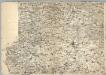
74. Salzwedel, uit: Topographische Uebersichtskarte des Deutschen Reiches / herausgegeben v. d. Kartogr. Abt. d. Königl. Preuß. Landesaufnahme
1 : 200000 titelvariant: Topogr. Übersichtskarte des Deutschen Reiches; Annotatie: Titel boven bladen ook: Topogr. Übersichtskarte des Deutschen Reiches; Annotatie geografische gegevens: Op elk blad twee maatstokken: 10 Kilometer = 5,5 cm; 1 geogr. Meile = 3,6 cm; Legenda onder op elk blad Königlich Preußische Landesaufnahme. Kartographische Abtheilung [S.l : Königlich Preußische Landesaufnahme, Kartographische Abtheilung]
Carte topographique d'Allemagne
1 : 214500 Braniborsko (Německo) Jaeger, Johann Wilhelm Abraham Berndt, Johann Christoph I.W.A. Iaeger
Wittenberge 46, uit: Special-Karte von Mittel-Europa / nach amtlichen Quellen bearbeitet von W. Liebenow
1 : 300000 titelvariant: W. Liebenow's Mittel-Europa; Annotatie: Titel boven de bladen: W. Liebenow's Mittel-Europa Johannes Wilhelm Liebenow 1822-1897 Frankfurt a. M. : Ludwig Ravenstein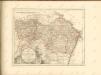

MARCHIONATUS | BRANDENBURGICI | PARS, quæ | MARCHIA VETUS, | Vulgo | ALTEMARCK, | dicitur.
[Amsterdam : Joan Blaeu]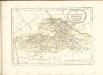

Composite: 211. Dannenberg. (Germany)
1 : 100000 Reichsamt fur Landesaufnahme
263. Wittingen.
1 : 100000 Reichsamt fur Landesaufnahme
Composite: 210. Lunenburg. (Germany)
1 : 100000 Reichsamt fur Landesaufnahme
211. Dannenberg. (Germany)
1 : 100000 Reichsamt fur Landesaufnahme
Meßtischblatt 1680 : Gr. Apenburg, 1873
1 : 250000 Gr. Apenburg. - Aufn. 1858/59. - 1:25000. - [Berlin]: Reichsamt für Landesaufnahme, 1873. - 1 Kt.
Meßtischblatt 3230 : Wittingen, 1939
1 : 250000 Wittingen. - Hrsg. 1901. - 1:25000. - [Berlin]: Reichsamt für Landesaufnahme, 1939. - 1 Kt.