Maps of Elbe-Havel-Land

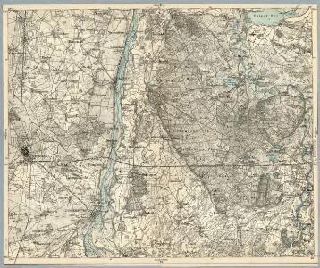
Composite: 266. Stendal.
1 : 100000 Reichsamt fur Landesaufnahme
266. Stendal.
1 : 100000 Reichsamt fur Landesaufnahme
Meßtischblatt 1829 : Jerichow, 1932
1 : 250000 Jerichow. - Hrsg. 1882, einz. Nachtr. 1932. - 1:25000. - [Berlin]: Reichsamt für Landesaufnahme, 1932. - 1 Kt.
Meßtischblatt 1828 : Tangermünde, 1904
1 : 250000 Tangermünde. - Aufn. 1880, einz. Nachtr. 1904. - 1:25000. - [Berlin]: Reichsamt für Landesaufnahme, 1904. - 1 Kt.
Meßtischblatt 1828 : Tangermünde, 1882
1 : 250000 Tangermünde. - Aufn. 1880. - 1:25000. - [Berlin]: Reichsamt für Landesaufnahme, 1882. - 1 Kt.
Meßtischblatt 3338 : Arneburg, 1954
1 : 250000 Arneburg. - Hrsg. 1882, letzte Nachtr. 1932, Ausg. 1950, redakt. Änderg. 1954. - 1:25000. - [Berlin]: MdI, 1954. - 1 Kt.
Meßtischblatt 3337 : Stendal, 1938
1 : 250000 Stendal. - Hrsg. 1882, einz. Nachtr. 1938. - 1:25000. - [Berlin]: Reichsamt für Landesaufnahme, 1938. - 1 Kt.
Meßtischblatt 1756 : Stendal, 1882
1 : 250000 Stendal. - Aufn. 1880. - 1:25000. - [Berlin]: Kgl. Preuss. Landesaufnahme, 1882. - 1 Kt.
Meßtischblatt 1830, neue Nr. 3439 : Vieritz, 1932
1 : 250000 Vieritz. - Hrsg. 1882, einz. Nachtr. 1932. - 1:25000. - [Berlin]: Reichsamt für Landesaufnahme, 1932. - 1 Kt.
Meßtischblatt 3339 : Schollene, 1955
1 : 250000 Schollene. - Hrsg. 1882, letzte Nachtr. 1932. - 1:25000. - [Berlin]: KVP, 1955. - 1 Kt.
75. Stendal, uit: Topographische Uebersichtskarte des Deutschen Reiches / herausgegeben v. d. Kartogr. Abt. d. Königl. Preuß. Landesaufnahme
1 : 200000 titelvariant: Topogr. Übersichtskarte des Deutschen Reiches; Annotatie: Titel boven bladen ook: Topogr. Übersichtskarte des Deutschen Reiches; Annotatie geografische gegevens: Op elk blad twee maatstokken: 10 Kilometer = 5,5 cm; 1 geogr. Meile = 3,6 cm; Legenda onder op elk blad Königlich Preußische Landesaufnahme. Kartographische Abtheilung [S.l : Königlich Preußische Landesaufnahme, Kartographische Abtheilung]
Meßtischblatt 1684 : Hindenburg, 1882
1 : 250000 Hindenburg. - Aufn. 1880. - 1:25000. - [Berlin]: Reichsamt für Landesaufnahme, 1882. - 1 Kt.
Meßtischblatt 3238 : Sandau, 1937
1 : 250000 Sandau. - Hrsg. 1882, einz. Nachtr. 1932. - 1:25000. - [Berlin]: Reichsamt für Landesaufnahme, 1937. - 1 Kt.
Meßtischblatt 1685 : Sandau, 1882
1 : 250000 Sandau. - Aufn. 1880. - 1:25000. - [Berlin]: Reichsamt für Landesaufnahme, 1882. - 1 Kt.
Meßtischblatt 3239 : Strodehne, 1950
1 : 250000 Strodehne. - Hrsg. 1882, Ausg. 1937. - 1:25000. - [S.l.] : Landesregierung Sachsen-Anhalt, Anstalt f. Kartogr., 1950. - 1 Kt.
Meßtischblatt 5535 : Lobenstein, [nach 1945]
1 : 250000 Lobenstein. - [Aufn. 1903, hrsg. 1905, ...]. - 1:25000. - [Berlin]: Reichsamt für Landesaufnahme, [nach 1945]. - 1 Kt.
Meßtischblatt 1686 : Strodehne, 1911
1 : 250000 Strodehne. - Aufn. 1880, hrsg. 1882, einz. Nachtr. 1911. - 1:25000. - [Berlin]: Reichsamt für Landesaufnahme, 1911. - 1 Kt.

MARCHIONATUS | BRANDENBURGICI | PARS, quæ | MARCHIA VETUS, | Vulgo | ALTEMARCK, | dicitur.
[Amsterdam : Joan Blaeu]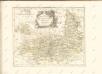

Magdebvrgensis Archiepiscopatvs
1 : 350000 Mollova mapová sbírka Blaeu, Joan Blaeu, Joan I.

Composite: 265. Gardelegen.
1 : 100000 Reichsamt fur Landesaufnahme
265. Gardelegen.
1 : 100000 Reichsamt fur Landesaufnahme
241. Havelberg.
1 : 100000 Reichsamt fur Landesaufnahme
Meßtischblatt 1827 : Lüderitz, 1902
1 : 250000 Lüderitz. - Aufn. 1900. - 1:25000. - [Berlin]: Reichsamt für Landesaufnahme, 1902. - 1 Kt.
Meßtischblatt 3336 : Schinne, 1938
1 : 250000 Schinne. - Hrsg. 1902, einz. Nachtr. 1938. - 1:25000. - [Berlin]: Reichsamt für Landesaufnahme, 1938. - 1 Kt.
Meßtischblatt 1683 : Osterburg, 1932
1 : 250000 Osterburg. - Hrsg. 1902, einz. Nachtr. 1932. - 1:25000. - [Berlin]: Reichsamt für Landesaufnahme, 1932. - 1 Kt.
Meßtischblatt 2336 : Demen, 1924
1 : 250000 Demen. - Hrsg. 1881. - 1:25000. - [Berlin]: Reichsamt für Landesaufnahme, 1924. - 1 Kt.