Maps of Highgate

Highgate Springs Port Of Entry
1 : 25000
Map of Keyes Landing on Lake Champlain, Franklin County, State of Vermont
1 : 2400 Martin, Alexander, surveyor [s.n.]
Highgate Center
1 : 24000
Highgate Center
1 : 24000
Highgate Center
1 : 24000
A survey of Lake Champlain, including Lake George, Crown Point, and St. John
1 : 400000 Brasier, William Robert Sayer & John Bennett (Firm)
(This Topographical map of the Province of Lower Canada. Sheet) E.
1 : 174240 Faden, William, 1750?-1836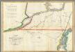
Map of the River St Lawrence and Adjacent Country.
1 : 291456 Melish, John
A SURVEY OF LAKE CHAMPLAIN
1 : 2700000 Brasier, William Amherst, Jeffery
[Map of northern Vermont]
Whitelaw, James, 1748-1829
Vermont
1 : 380160 Sotzmann, D. F. Bohn, Carl Ernst
Vermont.
1 : 850000 Colton, G.W.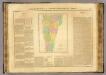
Vermont.
1 : 900000 Buchon, J. A. C.; Carey, H. C.; Lea, I.
Vermont.
1 : 590000 Rand McNally and Company
A map of the state of Vermont
1 : 700000 Whitelaw, James
Vermont.
1 : 835000 Colton, G.W.
Vermont, from actual survey, with all the late additions & improvements
1 : 237600 Whitelaw, James Hutchinson, Ebenezer
Vermont.
1 : 570000 Rand McNally and Company
Vermont.
1 : 995000 Lucas, Fielding Jr.
Map exhibiting the Farmington & Hampshire & Hampden canals, together with the line of their proposed continuation through the Valley of the Connecticut River to Canada

Vermont.
1 : 412000 Rand McNally and Company
Vermont.
1 : 895000 Cram, George Franklin; Davis, Ellis Arthur
Vermont.
1 : 1070000 Finley, Anthony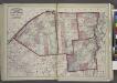
"St. Lawrence, Franklin, Clinton, and Essex"
from New topographical atlas and gazetteer of New York, comprising a topographical view of the several counties of the state, ... including ... map of the United States and territories ... Compiled from the latest astronomical observations, official surveys and records of the United States and territories ...
Vermont.
1 : 850000 Colton, G.W.
Vermont.
1 : 1070000 Lucas, Fielding Jr.
Vermont.
1 : 850000 Colton, G.W.
A correct map of the State of Vermont, from actual survey : exhibiting the county and town lines, rivers, lakes, ponds, mountains, meetinghouses, mills, public roads, &c
1 : 240000 Whitelaw, James, 1748-1829 [s.n.]
An improved map of Vermont : compiled from the latest authorities
1 : 450000 Robinson, Lewis, 1793-1871 Lewis Robinson

