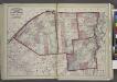
Maps of Hemmingford (village)

Mooers Station
1 : 25000
Mooers
1 : 24000
Mooers
1 : 62500
Mooers
1 : 62500
Mooers
1 : 62500
Mooers
1 : 62500
Mooers
1 : 62500
Mooers
1 : 62500
Mooers
1 : 62500
Mooers
1 : 62500
Mooers
1 : 62500
Mooers
1 : 62500
Mooers
1 : 62500
Mooers
1 : 62500
Mooers
1 : 62500
"Plan of Clinton Co., N.Y."
from Atlas of Clinton Co., New York : from actual surveys / by and under the direction of F.W. Beers, assisted by Geo. P. Sanford & others.
A Survey of Lake Champlain, including Lake George, Crown Point and St. John.
1 : 400000 Robert Sayer and John Bennett (Firm)
(This Topographical map of the Province of Lower Canada. Sheet) A.
1 : 174240 Faden, William, 1750?-1836
A survey of Lake Champlain, including Lake George, Crown Point, and St. John
1 : 400000 Brasier, William Robert Sayer & John Bennett (Firm)
(This Topographical map of the Province of Lower Canada. Sheet) E.
1 : 174240 Faden, William, 1750?-1836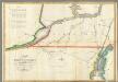
Map of the River St Lawrence and Adjacent Country.
1 : 291456 Melish, John
A SURVEY OF LAKE CHAMPLAIN
1 : 2700000 Brasier, William Amherst, Jeffery
[Map of northern Vermont]
Whitelaw, James, 1748-1829
Vermont.
1 : 850000 Colton, G.W.
A map of the state of Vermont
1 : 700000 Whitelaw, James
Vermont, from actual survey, with all the late additions & improvements
1 : 237600 Whitelaw, James Hutchinson, Ebenezer
Vermont.
1 : 570000 Rand McNally and Company
Vermont.
1 : 995000 Lucas, Fielding Jr.
Vermont.
1 : 1070000 Finley, Anthony