Maps of Havelock

Cannon Corners Station
1 : 25000
Ellenburg Depot
1 : 24000
Ellenburg Depot
1 : 24000
Churubusco
1 : 62500
Churubusco
1 : 62500
Churubusco
1 : 62500
Churubusco
1 : 62500
Churubusco
1 : 62500
Churubusco
1 : 62500
Churubusco
1 : 62500
Churubusco
1 : 62500
"Plan of Clinton Co., N.Y."
from Atlas of Clinton Co., New York : from actual surveys / by and under the direction of F.W. Beers, assisted by Geo. P. Sanford & others.
(This Topographical map of the Province of Lower Canada. Sheet) A.
1 : 174240 Faden, William, 1750?-1836
Outline plan of Franklin Co.
from Atlas of Franklin County, New York. : From actual surveys and official records.
(This Topographical map of the Province of Lower Canada. Sheet) E.
1 : 174240 Faden, William, 1750?-1836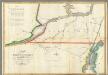
Map of the River St Lawrence and Adjacent Country.
1 : 291456 Melish, John
A SURVEY OF LAKE CHAMPLAIN
1 : 2700000 Brasier, William Amherst, Jeffery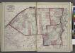
"St. Lawrence, Franklin, Clinton, and Essex"
from New topographical atlas and gazetteer of New York, comprising a topographical view of the several counties of the state, ... including ... map of the United States and territories ... Compiled from the latest astronomical observations, official surveys and records of the United States and territories ...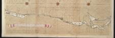
La riviere de Canada ou de St. Laurens de I. de Montreal jusqu'à le lac Ontario aux Nord de l'Amérique
Canada Gerard van Keulen
Vermont.
1 : 1070000 Lucas, Fielding Jr.
A correct map of the State of Vermont, from actual survey : exhibiting the county and town lines, rivers, lakes, ponds, mountains, meetinghouses, mills, public roads, &c
1 : 240000 Whitelaw, James, 1748-1829 [s.n.]
An improved map of Vermont : compiled from the latest authorities
1 : 450000 Robinson, Lewis, 1793-1871 Lewis Robinson
Vermont.
1 : 1100000 Tanner, Henry S.
A correct map of the State of Vermont, from actual survey : exhibiting the county and town lines, rivers, lakes, ponds, mountains, meetinghouses, mills, public roads, &c
1 : 245000 Whitelaw, James, 1748-1829 James Whitelaw
State Of Vermont
1 : 160000 Walling, H. F.
An improved map of Vermont : compiled from the latest authorities
1 : 450000 Robinson, Lewis, 1793-1871 Lewis Robinson
Vermont.
1 : 850000 Colton, G.W.
State of Vermont Drawn and Engraved.
1 : 1393920 Scott, Joseph
Vermont.
1 : 838000 Gray, Ormando Willis

