Maps of Otsego County

West Davenport
1 : 31680
West Davenport
1 : 24000
West Davenport
1 : 24000
West Davenport
1 : 24000
Delhi
1 : 62500
Delhi
1 : 62500
Delhi
1 : 62500
Delhi
1 : 62500
Delhi
1 : 62500
Delhi
1 : 62500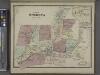
West Oneonta [Village]; West Oneonta Business Directory. ; Town of Oneonta, Otsego Co. N.Y. [Township]
from Atlas of Otsego Co., New York. From actual surveys by and under the direction of F.W. Beers, assisted by F.S. Fulmer & others.
Otsego County.
1 : 151000 Burr, David H., 1803-1875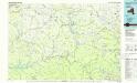
Pepacton Reservoir
1 : 100000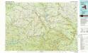
Pepacton Reservoir
1 : 100000
Delaware County.
1 : 151000 Burr, David H., 1803-1875
Otsego, Delaware counties.
1 : 158400 Bien, Joseph Rudolf
Binghamton
1 : 250000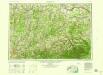
Binghamton
1 : 250000
Binghamton
1 : 250000
Binghamton
1 : 250000
Binghamton
1 : 250000
Van Loan's road map of the Catskills and vicinity : all of Greene County, most of Ulster and Delaware counties, and large portions of Albany, Schoharie, Otsego, and Sullivan counties
1 : 221760 Van Loan, Walton Walton Van Loan
"Onondaga, Cortland, Broome, Madison, and Chenango Counties"
from New topographical atlas and gazetteer of New York, comprising a topographical view of the several counties of the state, ... including ... map of the United States and territories ... Compiled from the latest astronomical observations, official surveys and records of the United States and territories ...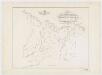
Map of the head waters of the rivers Susquehanna & Delaware embracing the early patents on the south side of the Mohawk River : from the original, drawn about the year 1790
1 : 260000 De Witt, Simeon, 1756-1834 Weed, Parsons & Co.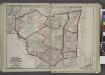
"Delaware, Sullivan, Greene, Ulster, Orange, Columbia, Dutchess, and Putman Counties"
from New topographical atlas and gazetteer of New York, comprising a topographical view of the several counties of the state, ... including ... map of the United States and territories ... Compiled from the latest astronomical observations, official surveys and records of the United States and territories ...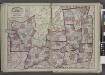
"Oneida, Madison, Otsego, Fulton, Montgomery, Schenectady, Albany, Schoharie, Warren, Saratoga, Washington, and Rensselaer Counties"
from New topographical atlas and gazetteer of New York, comprising a topographical view of the several counties of the state, ... including ... map of the United States and territories ... Compiled from the latest astronomical observations, official surveys and records of the United States and territories ...
[Kaart], uit: Travellers' guide of the Hudson River
1 : 650000 Annotatie: Met beknopte beschrijving van de belangrijkste aan de Hudson gelegen plaatsen [S.l. : H.B. Kirkham]
Province de New-York : en 4 feuilles / par Montrésor.
from (A-Z)
New York.
1 : 614000 Hammond, C.S.

