Maps of Columbia County

Ancram
1 : 24000
Ancram
1 : 24000
Ancram
1 : 24000
Ancram
1 : 24000
Ancram
1 : 24000
Ancram
1 : 24000
Gallatin [Township]
from Atlas of Columbia County, New York. From actual surveys and official records. Compiled & published by D. G. Beers & Co.
Copake
1 : 62500
Copake
1 : 62500
Copake
1 : 62500
Copake
1 : 62500
Copake
1 : 62500
Copake
1 : 62500
Copake
1 : 62500
Copake
1 : 62500
Map of Pine Plains Township. ; Pine Plains [Village]; Rock City [Village]
from New illustrated atlas of Dutchess County, New York. / Compiled & drawn from personal examinations, surveys etc. under the personal supervision of O.W. Gray & Son and F.A. Davis, and published under the superintendence of H. L. Kochersperger.
Taghkanic [Township]
from Atlas of Columbia County, New York. From actual surveys and official records. Compiled & published by D. G. Beers & Co.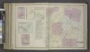
Charyville [Village]; Copake Station [Village]; Copake Flats [Village]; Gallatinville [Village]; Copake Business Notices.; Copake [Township]
from Atlas of Columbia County, New York. From actual surveys and official records. Compiled & published by D. G. Beers & Co.
Ancram [Township]
from Atlas of Columbia County, New York. From actual surveys and official records. Compiled & published by D. G. Beers & Co.
Livington [Township]; Glenco Mills [Village]; Livington Business Notices.; Lebanon Springs [Village]; Johnstown [Village]
from Atlas of Columbia County, New York. From actual surveys and official records. Compiled & published by D. G. Beers & Co.
Milan [Township]
from New illustrated atlas of Dutchess County, New York. / Compiled & drawn from personal examinations, surveys etc. under the personal supervision of O.W. Gray & Son and F.A. Davis, and published under the superintendence of H. L. Kochersperger.
Town of Milan, Dutchess County New York. (insets) Milanville. Rock City. Lafayetteville. Jackson's Corners.
1 : 47639 Beers, Frederick W.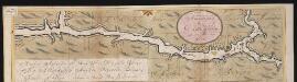
Nieuwe afteekeningh van de Noord Rivier met alle desselfs ancker plaetsen dieptens banken en klippen, geleegen in Nieuw Nederlandt [south part]
United States Gerard van Keulen
Pittsfield
1 : 100000
Pittsfield
1 : 100000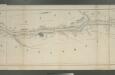
Map of the Hudson River Rail Road from New York to Albany / engraved by Robt. Haering, N.Y. ; W.C. Moore, del.
from Hudson River
Hudson River & vicinity / drawn by David H. Burr ; S. Stiles & Co., N.Y.
from Hudson River
Columbia Co.
from Atlas of Columbia County, New York. From actual surveys and official records. Compiled & published by D. G. Beers & Co.
Map of the county of Berkshire, Massachusetts : based upon the trigonometrical survey of the state
1 : 50688 Walling, Henry Francis, 1825-1888 Smith, Gallup & Co.

