Maps of Dutchess County

Milan [Township]
from New illustrated atlas of Dutchess County, New York. / Compiled & drawn from personal examinations, surveys etc. under the personal supervision of O.W. Gray & Son and F.A. Davis, and published under the superintendence of H. L. Kochersperger.
Town of Milan, Dutchess County New York. (insets) Milanville. Rock City. Lafayetteville. Jackson's Corners.
1 : 47639 Beers, Frederick W.
Rock City
1 : 24000
Rock City
1 : 24000
Rock City
1 : 24000
Gallatin [Township]
from Atlas of Columbia County, New York. From actual surveys and official records. Compiled & published by D. G. Beers & Co.
Map of Pine Plains Township. ; Pine Plains [Village]; Rock City [Village]
from New illustrated atlas of Dutchess County, New York. / Compiled & drawn from personal examinations, surveys etc. under the personal supervision of O.W. Gray & Son and F.A. Davis, and published under the superintendence of H. L. Kochersperger.
Red Hook [Township]
from New illustrated atlas of Dutchess County, New York. / Compiled & drawn from personal examinations, surveys etc. under the personal supervision of O.W. Gray & Son and F.A. Davis, and published under the superintendence of H. L. Kochersperger.
Clermont
1 : 24000
Clermont
1 : 24000
Clermont
1 : 24000
Clermont
1 : 24000
Pine Plains
1 : 24000
Pine Plains
1 : 24000
Pine Plains
1 : 24000
Pine Plains
1 : 24000
Pine Plains
1 : 24000
Rhinebeck [Township]
from New illustrated atlas of Dutchess County, New York. / Compiled & drawn from personal examinations, surveys etc. under the personal supervision of O.W. Gray & Son and F.A. Davis, and published under the superintendence of H. L. Kochersperger.
Map of Dutchess County New York
from New illustrated atlas of Dutchess County, New York. / Compiled & drawn from personal examinations, surveys etc. under the personal supervision of O.W. Gray & Son and F.A. Davis, and published under the superintendence of H. L. Kochersperger.
The Hudson by daylight map, from New York Bay to the head of tide water : containing names of streams, islands, and heights of mountains according to the latest coast survey : also the names of prominent residences, historic land marks, the old reaches o
from Hudson River
Dutchess County.
1 : 158400 Bien, Joseph Rudolf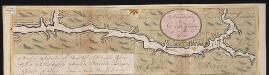
Nieuwe afteekeningh van de Noord Rivier met alle desselfs ancker plaetsen dieptens banken en klippen, geleegen in Nieuw Nederlandt [south part]
United States Gerard van Keulen
Livington [Township]; Glenco Mills [Village]; Livington Business Notices.; Lebanon Springs [Village]; Johnstown [Village]
from Atlas of Columbia County, New York. From actual surveys and official records. Compiled & published by D. G. Beers & Co.
Rhinebeck
1 : 62500
Rhinebeck
1 : 62500
Rhinebeck
1 : 62500
Rhinebeck
1 : 48000
Rhinebeck
1 : 62500
Rhinebeck
1 : 62500
Rhinebeck
1 : 62500
Rhinebeck
1 : 62500
Rhinebeck
1 : 62500
Rhinebeck
1 : 62500
Rhinebeck
1 : 62500
Rhinebeck
1 : 62500
Rhinebeck
1 : 62500
![Milan [Township]](https://images-2.georeferencer.com/images/iiif/219643212142/full/,300/0/native.jpg)

