Maps of New York

Alcove
1 : 24000
Alcove
1 : 24000
Alcove
1 : 24000
Wilmington
1 : 25000
Coxsackie
1 : 62500
Coxsackie
1 : 62500
Coxsackie
1 : 62500
Coxsackie
1 : 62500
Coxsackie
1 : 62500
Coxsackie
1 : 62500
Coxsackie
1 : 62500
Coxsackie
1 : 62500
Coxsackie
1 : 62500
Coxsackie
1 : 62500
Coxsackie
1 : 62500
Coxsackie
1 : 62500
Columbia County.
1 : 151000 Burr, David H., 1803-1875
Coeymans [Village]; Indian Fields Business Directory.
from New topographical atlas of the counties of Albany and Schenectady, New York : from actual surveys / by S.N. & D.G. Beers and assistants.
Westerlo [Township]
from New topographical atlas of the counties of Albany and Schenectady, New York : from actual surveys / by S.N. & D.G. Beers and assistants.
Greene County.
1 : 151000 Burr, David H., 1803-1875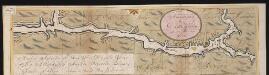
Nieuwe afteekeningh van de Noord Rivier met alle desselfs ancker plaetsen dieptens banken en klippen, geleegen in Nieuw Nederlandt [south part]
United States Gerard van Keulen
Pittsfield
1 : 100000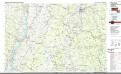
Pittsfield
1 : 100000
Map of Albany County.
from New topographical atlas of the counties of Albany and Schenectady, New York : from actual surveys / by S.N. & D.G. Beers and assistants.
Columbia Co.
from Atlas of Columbia County, New York. From actual surveys and official records. Compiled & published by D. G. Beers & Co.
Map of the county of Greene / by David H. Burr ; engd. by Rawdon, Clark & Co., Albany, & Rawdon, Wright & Co., New York.
from An atlas of the state of New York : containing a map of the state and of the several counties. / Projected and drawn under the superintendence and direction of Simeon de Witt ... And also the physical geography of the State ...
A prospective plan of the battle fought near Lake George on the 8th of September, 1755 between 2000 English with 250 Mohawks under the command of General Johnson and 2500 French and Indians under the command of General Dieskau ...
Blodget, Samuel
Albany, Rensselaer, Columbia counties.
1 : 158400 Bien, Joseph Rudolf
Plan of the encampment and position of the army under His Excelly. Lt. General Burgoyne at Swords House on Hudson's River near Stillwater on Septr. 17th : with the positions of that part of the army engaged on the 19th Septr. 1777 / drawn by W. C. Wilkin
from Revolutionary War

