Maps of Greene County

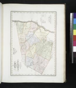
Map of the county of Greene / by David H. Burr ; engd. by Rawdon, Clark & Co., Albany, & Rawdon, Wright & Co., New York.
from An atlas of the state of New York : containing a map of the state and of the several counties / by David H. Burr.
Map of the county of Greene / by David H. Burr ; engd. by Rawdon, Clark & Co., Albany, & Rawdon, Wright & Co., New York.
from An atlas of the state of New York, designed for the use of engineers, containing a map of the state and of the several counties. / Projected and drawn ... under the superintendence and direction of Simeon de Witt.
Map of the county of Greene / by David H. Burr ; engd. by Rawdon, Clark & Co., Albany, & Rawdon, Wright & Co., New York.
from An atlas of the state of New York : containing a map of the state and of the several counties. / Projected and drawn under the superintendence and direction of Simeon de Witt ... And also the physical geography of the State ...
Map of Livingston Manor, 1714
from Cities and towns, A-Z
Greene County.
1 : 151000 Burr, David H., 1803-1875
Columbia Co.
from Atlas of Columbia County, New York. From actual surveys and official records. Compiled & published by D. G. Beers & Co.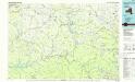
Pepacton Reservoir
1 : 100000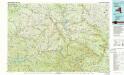
Pepacton Reservoir
1 : 100000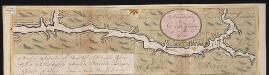
Nieuwe afteekeningh van de Noord Rivier met alle desselfs ancker plaetsen dieptens banken en klippen, geleegen in Nieuw Nederlandt [south part]
United States Gerard van Keulen
Map of Albany County.
from New topographical atlas of the counties of Albany and Schenectady, New York : from actual surveys / by S.N. & D.G. Beers and assistants.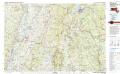
Pittsfield
1 : 100000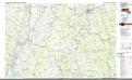
Pittsfield
1 : 100000
The Hudson by daylight map, from New York Bay to the head of tide water : containing names of streams, islands, and heights of mountains according to the latest coast survey : also the names of prominent residences, historic land marks, the old reaches o
from Hudson River
Broome [Township]
from New topographical atlas of Schoharie Co., New York. From actual surveys by S.N. & D.G. Beers and assistants.
Livington [Township]; Glenco Mills [Village]; Livington Business Notices.; Lebanon Springs [Village]; Johnstown [Village]
from Atlas of Columbia County, New York. From actual surveys and official records. Compiled & published by D. G. Beers & Co.
Columbia County.
1 : 151000 Burr, David H., 1803-1875
New York
1 : 2000000 Breese, S.
Map of Dutchess County New York
from New illustrated atlas of Dutchess County, New York. / Compiled & drawn from personal examinations, surveys etc. under the personal supervision of O.W. Gray & Son and F.A. Davis, and published under the superintendence of H. L. Kochersperger.
Schoharie County.
1 : 151000 Burr, David H., 1803-1875
Hudson River & vicinity / drawn by David H. Burr ; S. Stiles & Co., N.Y.
from Hudson River
North Chatham. [Village]; Chatham Business Notices.; Ridder's Mills [Village]; Chatham [Township]
from Atlas of Columbia County, New York. From actual surveys and official records. Compiled & published by D. G. Beers & Co.
Coeymans [Village]; Indian Fields Business Directory.
from New topographical atlas of the counties of Albany and Schenectady, New York : from actual surveys / by S.N. & D.G. Beers and assistants.
Catskill
1 : 62500
Catskill
1 : 62500
Catskill
1 : 62500
Catskill
1 : 62500
Catskill
1 : 62500
Margaretville
1 : 62500
Margaretville
1 : 62500
Margaretville
1 : 62500
Margaretville
1 : 62500
Margaretville
1 : 62500
Margaretville
1 : 62500
Margaretville
1 : 62500
Copake
1 : 62500
Copake
1 : 62500
Copake
1 : 62500
Copake
1 : 62500
Copake
1 : 62500
Copake
1 : 62500
Copake
1 : 62500
Phoenicia
1 : 62500
Phoenicia
1 : 62500
Phoenicia
1 : 62500
Phoenicia
1 : 62500
Phoenicia
1 : 62500
Phoenicia
1 : 62500
Phoenicia
1 : 62500
Phoenicia
1 : 62500
Phoenicia
1 : 62500
Kaaterskill
1 : 62500
Kaaterskill
1 : 62500
Kaaterskill
1 : 62500
Kaaterskill
1 : 62500
Kaaterskill
1 : 62500
Kaaterskill
1 : 62500
Kaaterskill
1 : 62500
Kaaterskill
1 : 62500
Kaaterskill
1 : 62500
Kaaterskill
1 : 62500
Copake
1 : 62500
Margaretville
1 : 62500
Phoenicia
1 : 62500
Kaaterskill
1 : 62500
Kaaterskill
1 : 62500
Catskill
1 : 62500
Catskill
1 : 62500
Catskill
1 : 62500
Catskill
1 : 62500
Catskill
1 : 62500
Catskill
1 : 62500
Catskill
1 : 62500
Catskill
1 : 62500
Catskill
1 : 62500
Catskill
1 : 62500
Kaaterskill
1 : 62500
Kaaterskill
1 : 62500
Kaaterskill
1 : 62500
Kaaterskill
1 : 62500