Maps of Metropolitan France

Poli arctici, et circumiacentium terrarum descriptio novissima / sumptibus Henrici Hondÿ
1 : 21000000 1 Karte : Kupferdruck ; 43 x 49 cm Hondius, Hendrik Henricus Hondius
The Western Ocean.
from Charts and maps Jeremiah Seller & Charles Price?: [London?],
Europe / gravé par J.B. Tardieu ; ecrit par Giraldon
1 : 22000000 1 Karte : Kupferdruck ; 21 x 27 cm Tardieu, Jean-Baptiste Pierre [Verlag nicht ermittelbar]
Plate 4: Part of Section 7.
from Atlas of the city of New York, borough of Manhattan / from actual surveys and official plans by George W. and Walter S. Bromley.
Map of New York City, (Greater New York).
From Manhattan
Map N.P.R.R.
1 : 2876900 Northern Pacific Railroad Company
Europa / in Stahl gest. v. C. Metzeroth
1 : 12300000 1 Karte : Stahlstich ; 17 x 20 cm Metzeroth, Carl Geographische Anstalt des Bibliographischen Instituts
Asien
1 : 35000000 1 Karte : Lithogr. (mehrfarb.) ; 18 x 23 cm Sydow, Emil von Justus Perthes
Asien
1 : 35000000 1 Karte : Lithogr. (mehrfarb.) ; 18 x 23 cm Sydow, Emil von Justus Perthes
Asie / gravé par Chamouin ; ecrit par Giraldon
1 : 43800000 1 Karte : Kupferdruck ; 21 x 29 cm Chamouin, Jean Baptiste Marie [Verlag nicht ermittelbar]
Tavola della trasmigrazione de barbari che hanno invaso l'Impero Romano: loro cammino : partenza, e
1 : 13500000 1 Karte : Kupferdruck ; dalla tipografia dell'editore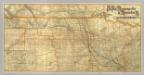
St. Paul, Minneapolis & Manitoba Ry.
1 : 1531600 St. Paul, Minneapolis & Manitoba Railway Company.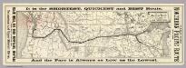
Map of the Northern Pacific Railroad and connections.
1 : 7500000 Rand McNally and Company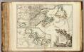
Nouvelle France ou le Canada.
1 : 4000000 Robert de Vaugondy, Gilles, 1688-1766
Sibérie, avec L'Amérique russe / gravé par Chamouin ; ecrit par Giraldon
1 : 31000000 1 Karte : Kupferdruck ; 21 x 29 cm Chamouin, Jean Baptiste Marie [Verlag nicht ermittelbar]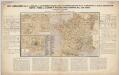
Nieuwe aardrijkskundige kaart van Frankrijk met geschiedkundig overzicht van den Duitsch-Franschen oorlog 1870-71 en aanteekening der Duitsche legerbewegingen, benevens de plannen der slagvelden om Weissenburg, Wörth, Saarbruggen, Metz, Sedan en Parijs / bewerkt door F.E.L.A. Abel ...
1 : 2400000 Annotatie: Met omringende tekst en tabellen; Annotatie geografische gegevens: Legenda F.E.L.A. Abel 's Hage : lithographie en uitgave van J. Smulders & Co ...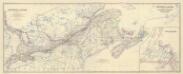
Composite: Canada.
1 : 2065500 Johnston, Alexander Keith, 1804-1871
The European part of the Russian Empire, from the maps publishd by the Imperial Academy at St. Peter
1 : 8200000 1 Karte auf 2 Bl. : Kupferdruck ; 47 x 128 cm ; Einzelbl. 47 x 64 cm published 12th May 1794 by Lawrie & Whittle, No.53 Fleet Street
British Provinces in Canada.
1 : 7247550 Fisher, Richard Swainson
Tabula Russiae / ex mandato Foedor Borissowits delineata, Magno studio plurimis in locis aucta, edit
1 : 7900000 1 Karte : Kupferdruck ; 41 x 52 cm Visscher, Claes Jansz. [Nicolas Visscher]
Novissima Russiæ tabula / authore Isaaco Massa
1 : 840000 1 Karte : Kupferdruck ; 46 x 54 cm Massa, Isaac Abrahamsz Apud Janssonio-Waesbergios et Mosem Pitt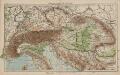
Österreich-Ungarn und Alpenländer
1 : 4000000 Österreich-Ungarn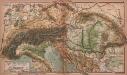
Alpen- und Karpatenländer
1 : 4000000 Alpenländer, Österreich-Ungarn
Österreich-Ungarn und Alpenländer. Bodengestalt
1 : 4000000 Österreich-Ungarn Physische Geografie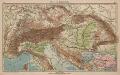
Alpen- und Karpatenländer
1 : 4000000 Alpenländer, Österreich-Ungarn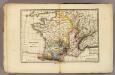
France physique.
1 : 4400000 Vincent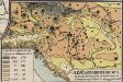
Bevölkerungsdichte
Österreich-Ungarn Bevölkerungsdichte
Austria.
1 : 4700000 Tanner, Henry S.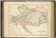
Austrian Empire.
1 : 2534400 Fullarton, A. & Co.
Austria.
1 : 3928320 Colton, G.W.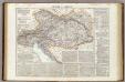
Impero d'Austria.
1 : 2800000 Picquet, C.
Austrian Empire.
1 : 4200000 Mitchell, Samuel Augustus
Austrian Empire.
1 : 4300000 Tanner, Henry S.