Maps of Les Laurentides

The Western Ocean.
from Charts and maps Jeremiah Seller & Charles Price?: [London?],
Plate 4: Part of Section 7.
from Atlas of the city of New York, borough of Manhattan / from actual surveys and official plans by George W. and Walter S. Bromley.
Europe / gravé par J.B. Tardieu ; ecrit par Giraldon
1 : 22000000 1 Karte : Kupferdruck ; 21 x 27 cm Tardieu, Jean-Baptiste Pierre [Verlag nicht ermittelbar]
Europa / in Stahl gest. v. C. Metzeroth
1 : 12300000 1 Karte : Stahlstich ; 17 x 20 cm Metzeroth, Carl Geographische Anstalt des Bibliographischen Instituts
A New and correct map of the British colonies in North America comprehending eastern Canada with the province of Quebec, New Brunswick, Nova Scotia, and the Government of Newfoundland: with the adjacent states of New England, Vermont, New York, Pennsylvania and New Jersey.
from Charts and maps Publish'd by Laurie & Whittle, 53 Fleet Street: London; Robert Laurie and James Whittle,
British colonies North America, New England.
1 : 3800000 Robert Laurie & James Whittle
A New and correct map of the British colonies in North America comprehending eastern Canada with the province of Quebec, New Brunswick, Nova Scotia, and the Government of Newfoundland: with the adjacent states of New England, Vermont, New York, Pennsylvania and New Jersey.
from John H. Levine Collection Publish'd by Laurie & Whittle, 53 Fleet Street: London; Robert Laurie and James Whittle,
France &c.
1 : 2400000 Brue, Adrien Hubert, 1786-1832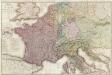
Composite: France.
1 : 1170000 Herisson, Eustache, b. 1759
Nova tabula geographica complectens borealiorem Americae partem : in qua exacte delineatae sunt Canada sive Nova Francia, Nova Scotia, Nova Anglia, Novum Belgium, Pensylvania, Virginia, Carolina et Terra Nova : cum omnibus littorum pulvinorumque profundi
from John H. Levine Collection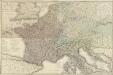
Carte géographique et administrative du Royaume de France comprenant en outre le Royaume des Pays-Bas, l'Allemagne, l'Empire d'Autriche, la Suisse, les Etats du Roi de Sardaigne sur le continent, les duchés de Parme et de Toscane, l'Etat de l'Eglise, l'Ile d'Elbe, les Sept-Iles Ioniennes en supplement et une partie de l'Empire Turc, des Royaumes de Prusse, de Naples, d'Angleterre, d'Espagne jusqu'à Madrid
1 : 1200000 dessinée par Hérisson Paris : chez Desray, J. Goujon
Drift Eis im Nordatlantischen Ocean
Atlantský oceán Redfield, W. C. D. Reimer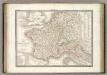
France 1789, 1813.
1 : 3700000 Lapie, M. (Pierre), 1779-1850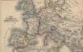
Das Zeitalter der Hohenstaufen
Mitteleuropa
[Historisch-geographischer Atlas zu den allgemeinen Geschichtswerken von C. v. Rotteck, Pölitz u. Becker] : Das Reich Karls des Grossen nach der Theilung seiner Enkel zu Verdun 843
von Julius Loewenberg Lithographie von B. Herder in Freiburg im Breisgau [Freiburg im Breisgau] : [Herder]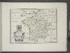
France, and parts adjoining.
from A new sett of maps both of antient and present geography : wherein not only the latitude and longitude of many places are corrected according to the latest observations, but also the most remarkable differences of antient and present geography may be quickly discern'd by a bare inspection or comparing of correspondent maps, which seems to be the most natural and easy method to lead young students (for whose use the work is principally intended) unto a competent knowledge of the geographical science : together with a geographical treatise particularly adapted to the use and design of these maps / by Edward Wells, M.A. and student of Christ-Church, Oxon.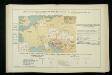
Izvoz robe i vrijednost produkcije većih tvornica 1912. Kralj. Hrvatska i Slavonija
Kroatien Slawonien Export Statistik Industrie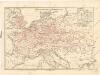
Eisenbahnkarte von Mitteleuropa

A general map of the northern British colonies in America: which comprehends the province of Quebec, the government of Newfoundland, Nova-Scotia, New-England and New-York / from the maps published by the Admiralty and Board of Trade, regulated by the astronomic and trigonometric observations of Major Holland, and corrected from Governor Pownall's late map 1776.
from Parts Samuel Holland,
Kriegszusammenhänge IV (1740 - 1763)
1 : 15000000 Europa Österreichischer Erbfolgekrieg , Schlesische Kriege
Generalkarte von Nord America samt den westindischen Inseln
Severní Amerika Pownall Schraembl, Franz Anton F.A. Schraembl
Übersichtskarte des Eisenbahn- und Telegraphen-Verbindungen von Mittel-Europa
1 : 6170000 Evropa střední Mayer, Alexander
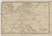
Germanie, France, Italie, Espagne, Isles Britanniques.
1 : 5200000 Anville, Jean Baptiste Bourguignon d, 1697-1782
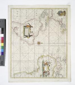
EXTREMA AMERICÆ | Versus Boream, ubi | TERRA NOVA | NOVA FRANCIA, Adjacentiaq.
Amstelaedami Io. Blaeu Exc.
A GENERAL MAP OF THE NORTHERN BRITISH COLONIES IN AMERICA
1 : 3800000 New Jersey Holland, Samuel
Itineraire-Karte
1 : 6000000 Evropa
Sbírka map a diagramů použitých na mírových konferencích v Paříži v letech 1919 - 1920

Tabula Europae III. [Karte], in: Geographia universalis vetus et nova complectens Claudii Ptolemaei Alexandrini enarrationis libros VIII, S. 228.
1 Karte aus Atlas Münster, Sebastian [und Ptolemaeus, Claudius]