Maps of Carpathian Mountains

Austria.
1 : 4700000 Tanner, Henry S.
Empire d'Autriche.
1 : 2800000 Picquet, C.
Charte der Oesterreichischen Monarchie

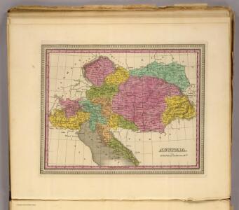
Austria.
1 : 5000000 Finley, Anthony
The European part of the Russian Empire, from the maps publishd by the Imperial Academy at St. Peter
1 : 8200000 1 Karte auf 2 Bl. : Kupferdruck ; 47 x 128 cm ; Einzelbl. 47 x 64 cm published 12th May 1794 by Lawrie & Whittle, No.53 Fleet Street
Alpen- und Karpatenländer
1 : 4000000 Alpenländer, Österreich-Ungarn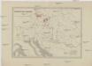
Rübenzucker-Fabriken der Österreichischen Monarchie
Rakousko (1804-1867)
Kaiserthum Oesterreich...

Uibersichts-Karte der österreichischen Rübenzucker-Fabriken
1 : 206000 Rakousko-Uhersko Bělský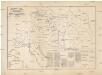
Uibersichts-Karte der österreichischen Rübenzucker-Fabriken
1 : 206000 Rakousko (1804-1867) Bělský Bělský
Uibersichts-Karte der oesterreichischen Rübenzucker-Fabriken
Rakousko (1804-1867)
Uibersichts-Karte der oesterreichischen Rübenzucker-Fabriken
Rakousko (1804-1867)
Sibérie, avec L'Amérique russe / gravé par Chamouin ; ecrit par Giraldon
1 : 31000000 1 Karte : Kupferdruck ; 21 x 29 cm Chamouin, Jean Baptiste Marie [Verlag nicht ermittelbar]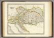
Austrian Empire.
1 : 2050000 Teesdale, Henry
Tabula Russiae / ex mandato Foedor Borissowits delineata, Magno studio plurimis in locis aucta, edit
1 : 7900000 1 Karte : Kupferdruck ; 41 x 52 cm Visscher, Claes Jansz. [Nicolas Visscher]
Oestreichs Laender unter den Roemern
1 : 2000000 Evropa jihovýchodní Renner, Emanuel von David, Johann J. G. Heubner
Oestreichs Laender unter den Roemern
1 : 2000000 Evropa jihovýchodní Renner, Emanuel von David, Johann J.G. Heubner
Oestreichs Laender unter den Roemern
1 : 2000000 Evropa jihovýchodní Renner, Emanuel von David, Johann J. G. Heubner
Novissima Russiæ tabula / authore Isaaco Massa
1 : 840000 1 Karte : Kupferdruck ; 46 x 54 cm Massa, Isaac Abrahamsz Apud Janssonio-Waesbergios et Mosem Pitt
Vývoj državy rakousko - uherské
Alpen- und Karpatenländer
1 : 4000000 Alpenländer, Österreich-Ungarn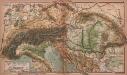
Alpen- und Karpatenländer
1 : 4000000 Alpenländer, Österreich-Ungarn
Austrian Dominions.
1 : 3750000 Hughes, William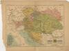
Mocnářství rakousko - uherské

Versuch einer Sprachenkarte der Österreichischen Monarchie
1 : 3000000 von J.V. Haeufler Pest : Emich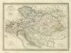
Composite: Carte Generale l'Empire d'Autriche.
1 : 2700000 Vivien de St Martin, L.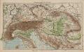
Österreich-Ungarn und Alpenländer
1 : 4000000 Österreich-Ungarn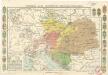
Dějepisná mapa mocnářství Rakousko-uherského

Uhry
1 : 1850000 Uhersko Merklas, Václav W. Merklas
Rakauské mocnářstwí
1 : 4500000 Rakousko-Uhersko Merklas, Václav W. Merklas