Maps of Upper Franconia

Partie orientale du cercle de Franconie
1 Karte : Kupferdruck ; 53 x 46 cm Condet chez Cóvens et Mortier
Partie orientale du cercle de Franconie
1 Karte : Kupferdruck ; 54 x 47 cm Le Rouge Georges Louis Le Rouge ruë des Augustins


Circuli Franconiae pars orientalis et potior novissime delineata
1 : 445000 quam [...] Circ. Francon. legatis [...] humillime D.D.D. Io. Bapt. Homann Norimbergae Norimbergae : Io. Bapt. Homann
Charte von dem Fränkischen Kreise
1 Karte : Kupferdruck ; 43 x 51 cm Kreibich im Verlage des Landes-Industrie-Comptoirs
Der Fraenkische Kreis
[50][50] Circulus Franconicus, ..., uit: Atlas sive Descriptio terrarum orbis
Annotatie: Gedigitaliseerde versie. Amsterdam. Heiloo : Picturae (vervaardiger), 2015. tiff-bestand. Gedigitaliseerd: 07-01-2015; Origineel: Universiteitsbibliotheek Vrije Universiteit (XL.05127.-) ; Netherlands; Titelpagina ontbreekt Wit, Frederik de Amsterdam : Frederick de Wit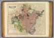
Franconia.
1 : 600000 Lizars, Daniel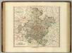
Franconia.
1 : 585000 Cary, John, ca. 1754-1835
Cercle de Franconie
1 Karte : Kupferdruck ; 47 x 55 cm Robert de Vaugondy; Haussard G. et D. Robert de Vaugondy
Charte von dem nordwestlichen Theile des Königreichs Bayern, dem Grossherzogthume Würzburg, dem Fürstenthume Aschaffenburg [et]c.c., oder der Maÿn
1 Karte : Kupferdruck ; 43 x 51 cm Kreibich im Verlage des Geographischen Instituts
Circulus Franconicus
1 : 530000 Mollova mapová sbírka Wit, Frederik de Wit, Frederick
Circuli Franconiae Pars Orientalis Novissima delienatio
1 : 650000 Mollova mapová sbírka Kauffer, Michael Kauffer, Michael
Circuli Franconiae Pars Orientalis et potior novissime delineata quam
1 : 430000 Mollova mapová sbírka Homann, Johann Baptist Homann, Johann Baptista
Circulus Franconicus ad orientem vergens
1 Karte : Kupferdruck ; 37 x 32 cm Weigel; Kauffer Christoph Weigel
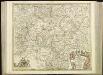
Circuli Franconiæ pars orientalis et potior novissime delineata
1 Karte : Kupferdruck ; 54 x 47 cm Homann Johann Baptist Homann
Circuli Franconiæ pars orientalis et potior novissime delineata
1 Karte : Kupferdruck ; 54 x 47 cm Homann Johann Baptist Homann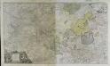
Circuli Franconiæ pars orientalis et potior novissime delineata
1 Karte : Kupferdruck ; 54 x 47 cm Homann Johann Baptist Homann
Circuli Franconiæ pars orientalis et potior novissime delineata
1 Karte : Kupferdruck ; 54 x 47 cm Homann Johann Baptist Homann
Circuli Franconiæ pars orientalis et potior novissime delineata
1 Karte : Kupferdruck ; 54 x 47 cm Schenk Pieter Schenk
Le Cercle de Franconie
1 : 600000 Mollova mapová sbírka Jaillot, Alexis-Hubert Ottens, Josua
Le Cercle de Franconie
1 : 600000 Mollova mapová sbírka Jaillot, Alexis-Hubert Jaillot, Alexis Hubert
Der Fraenkische Kreis
1 Karte : Kupferdruck ; 44 x 54 cm Güssefeld; Schmidt bey denen Homaennischen Erben
Franconiae Nova Descriptio. [Karte], in: Novus atlas absolutissimus, Bd. 2, S. 174.
1 Karte aus Atlas Janssonius Offizin
Der Frænkische Kreis nebst den angraenzenden Laendern
1 Karte : Kupferdruck ; 59 x 69 cm Hammer; Lochner im Verlag der kaiserlich privilegierten Homännischen Handlung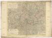
Der Fraenkische Kreis nebst den angraenzenden Laendern
1 : 350000 Franky (Německo) Hammer, C. F. Lochner, Carl Frid. im Verlag der kaiserlich privilegirten Hommanischen Handlung
Il circolo di Franconia diviso ne suoi stati
1 Karte : Kupferdruck ; 40 x 30 cm Zatta; Zuliani; Pitteri presso Antonio Zatta
Cercle de Franconie
1 Karte : Kupferdruck ; 46 x 54 cm Robert de Vaugondy; Remondini; Santini chez Mr. Remondini


