Maps of Upper Franconia

Partie orientale du cercle de Franconie
1 Karte : Kupferdruck ; 54 x 47 cm Le Rouge Georges Louis Le Rouge ruë des Augustins
Der Fraenkische Kreis

Circulus Franconicus ad orientem vergens
1 Karte : Kupferdruck ; 37 x 32 cm Weigel; Kauffer Christoph Weigel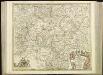
[50][50] Circulus Franconicus, ..., uit: Atlas sive Descriptio terrarum orbis
Annotatie: Gedigitaliseerde versie. Amsterdam. Heiloo : Picturae (vervaardiger), 2015. tiff-bestand. Gedigitaliseerd: 07-01-2015; Origineel: Universiteitsbibliotheek Vrije Universiteit (XL.05127.-) ; Netherlands; Titelpagina ontbreekt Wit, Frederik de Amsterdam : Frederick de Wit
Circulus Franconicus
1 : 530000 Mollova mapová sbírka Wit, Frederik de Wit, Frederick
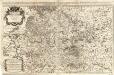
Partie orientale du cercle de Franconie
1 Karte : Kupferdruck ; 53 x 46 cm Condet chez Cóvens et Mortier
Franconiæ nova descriptio
1 Karte : Kupferdruck ; 40 x 52 cm Janssonius; Rittershausen Johannes Janssonius excud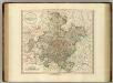
Franconia.
1 : 585000 Cary, John, ca. 1754-1835
Fränkischer Kreis
Allgemeiner Atlas [Walch, Johannes] im Verlag bei Johannes Walch
Franconiae Nova Descriptio. [Karte], in: Novus atlas absolutissimus, Bd. 2, S. 174.
1 Karte aus Atlas Janssonius Offizin
Der Fraenkische Kreis
1 Karte : Kupferdruck ; 44 x 54 cm Güssefeld; Schmidt bey denen Homaennischen Erben
Theatre de la Guerre en Baviere &c.
1 : 570000 Mollova mapová sbírka Mortier, Pieter Covens, Johannes I
Avstrasiorvm sive Franciae orientalis dvcatvs cvm pago Thvringiae avstralis, in svos pagos singvlares svb imperatoribvs Francicis et Saxonicis ex variis medii aevi diplomatibvs chartis ac docvmentis descriptvs
Durynsko (Německo)
Der Frænkische Kreis nebst den angraenzenden Laendern
1 Karte : Kupferdruck ; 59 x 69 cm Hammer; Lochner im Verlag der kaiserlich privilegierten Homännischen Handlung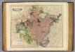
Franconia.
1 : 600000 Lizars, Daniel
Charte von dem Fränkischen Kreise
1 Karte : Kupferdruck ; 43 x 51 cm Kreibich im Verlage des Landes-Industrie-Comptoirs
Charte von Franken
1 Karte : Kupferdruck ; 43 x 51 cm Kreibich im Verlage des Geographischen Instituts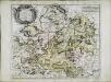
Cercle de Franconie
1 Karte : Kupferdruck ; 40 x 49 cm Sanson; Mariette chez Pierre Mariette rue St. Iacques a l'Esperance
Charte von dem nordwestlichen Theile des Königreichs Bayern, dem Grossherzogthume Würzburg, dem Fürstenthume Aschaffenburg [et]c.c., oder der Maÿn
1 Karte : Kupferdruck ; 43 x 51 cm Kreibich im Verlage des Geographischen Instituts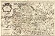
Le Cercle de Franconie subdivisé en touts les Estats qui le composent
1 : 510000 Mollova mapová sbírka Sanson, Guillaume Jaillot, Alexis Hubert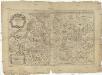
Circulus Franconiae divisus in certas ditiones
1 : 510000 Francie Sanson, Guillaume Hoffmann, Johann apud Johannem Hoffmanum
Le cercle de Franconie
1 Karte : Kupferdruck ; 44 x 59 cm Jaillot; Ottens; Ottens chez R. et J. Ottens
Le cercle de Franconie
1 Karte : Kupferdruck ; 44 x 59 cm Jaillot Alexis-Hubert Jaillot
Cercle de Franconie
1 Karte : Kupferdruck ; 46 x 54 cm Robert de Vaugondy; Remondini; Santini chez Mr. Remondini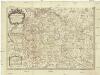
Le cercle de Franconie
1 : 570000 Franky (Německo) Sanson, Guillaume Cordier, Louis Iaillot
Il circolo di Franconia diviso ne suoi stati
1 Karte : Kupferdruck ; 40 x 30 cm Zatta; Zuliani; Pitteri presso Antonio Zatta
Circulus Franconiae
1 : 500000 Mollova mapová sbírka Hoffmann, Johannes Recknagel, B. Hofmann, Johann
Circvlvs Franconiae uti componitur ex Territoriis majoribus et minoribus Ecclesiasticis et Secularibus
1 : 1900000 Mollova mapová sbírka Franz, Johann Michael Homann, Johann Baptista - dědici
Le Cercle de Franconie
1 : 600000 Mollova mapová sbírka Jaillot, Alexis-Hubert Ottens, Josua


