Maps of Switzerland

Carte de la Republique des Suisses
1 Karte : Kupferdruck ; 47 x 59 cm Robert de Vaugondy; Groux G. et D. Robert de Vaugondy
Carte de la republique des Suisses
1 Karte : Kupferdruck ; 47 x 59 cm Robert de Vaugondy; Groux G. et D. Robert de Vaugondy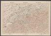
Suisse
1 : 600000 Topographische Anstalt Winterthur J. Schlumpf Topogr. Anstalt Winterthur, J. Schlumpf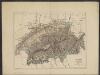
Suisse
1 : 1500000 Dunan, Maurice 1850-1919
Carte de la république des Suisses, où sont distingués les 13 cantons et leurs alliés, les sujets de ces cantons et ceux de leurs alliés
1 Karte par Robert de Vaugondy ; Groux [Verlag nicht ermittelbar], [Paris]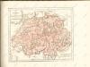

Carte physique & routière de la Suisse
1 : 500000 1 Karte dressés d'après des meilleurs matériaux par Jean Goll ; gravée par [Henri Louis Nicolas] Duval & [Rinaldo] Bressanini Henri Fuessli & Cie., Zürich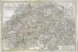
Carte de la Suisse ou l'on a marqué les routes suivies par M.re Wil. Coxe
1 Karte auf 2 Blatt : Kupferdruck ; 45 x 69 cm Coxe s.n.
Switzerland.
1 : 1290000 Tanner, Henry S.
Switzerland.
1 : 1290000 Tanner, Henry S.
Karte der Schweiz
1 : 650000 1 Karte entworfen und gestochen von J.H. Bachofen Verlag in J.H. Lochers Buchhandlung, Zürich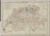
Topographischer Atlas der Schweiz (Siegfried-Karte): Den Kanton Zürich betreffende Blätter: Übersicht der Blätter
Leitung: Siegfried, Hermann (1819-1879), Topograf und Kartograf, von Zofingen AG; Eidgenössisches Topographisches Bureau, in Bern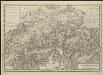
Carte nouvelle de la Suisse avec les routes des voyages faites en 1776, 1779, 1785 & 1786 par William Coxe, A.M.
Dl. Veelwaard, sculp. Amstelodam à Utrecht [etc.] : chèz B. Wild & J. Altheer [etc.]
Atlas für die Heimathskunde der Schweiz
1 : 19000000 1 Atlas (12, 12 Bl.) von J.S. Gerster ; gestochen von R. Leuzinger Dalp, Bern
La Suisse
1 Karte : Kupferdruck ; 43 x 54 cm Bonne; Santini G. A. Remondini?
Switzerland.
1 : 1280000 Mitchell, Samuel Augustus
Die Schweiz, oder, Helvetische Eidgenossenschaft
1 : 586000 Švýcarsko Weiland, Karl Ferdinand Geograph. Instituts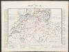
Historischer Atlas der Schweiz
1415 - 1460 Mandrot, Louis-Alphonse de Deutsche Buchhandlung von J. Kessmann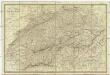
Carte physique et routiere de la Suisse
1 : 500000 Švýcarsko Andriveau-Goujon, J. J. Andriveau-Goujon
Postkarte der schweizerischen Eidgenossenschaft
1 : 300000 1 Karte offizielle Ausgabe durch das Post- und Bau-Departement und unter Aufsicht des General Dufour nach den gegenwärtig vorhandenen Materialien des eidgenössischen Atlasses und den besten Karten gezeichnet von J. R. Stengel u. E. Mohr Wurster, Winterthur
Die Schweiz
Geographischer Atlas über alle Theile der Erde Ziegler, Jakob Melchior Verlag von Dietrich Reimer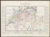
Historischer Atlas der Schweiz
1387 - 1415 Mandrot, Louis-Alphonse de Deutsche Buchhandlung von J. Kessmann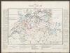
Historischer Atlas der Schweiz
1300 - 1387 Mandrot, Louis-Alphonse de Deutsche Buchhandlung von J. Kessmann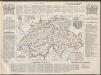
Historisch-Geographischer Atlas der Schweiz in 15 Blättern
1 : 770000 Kirchliche Einteilung der Schweiz Voegelin, Johann Conrad ; Meyer von Knonau, Gerold ; Wyss, Georg von ; Meyer von Knonau, Gerold Schulthess
Atlas für die Heimathskunde der Schweiz
1 : 19000000 1 Atlas (12, 12 Bl.) von J.S. Gerster ; gestochen von R. Leuzinger Dalp, Bern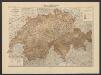
Zahl der Viehbesitzer in den verschiedenen Berzirken der Kantone
1 : 600000 Die Viehzucht und Milchwirthschaft der Schweiz Anderegg, Felix Verlag von J. Wurster & Comp. Landkartenhandlung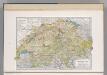
Switzerland.
1 : 879000 Hammond, C.S.
Karte der Posten, Telegraphen und Eisenbahnen der Schweizerischen Eidgenossenschaft
1 : 300000 Jent & Gassmann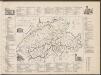
Historisch-Geographischer Atlas der Schweiz in 15 Blättern
1 : 770000 Konfessionelle Gestaltung der Schweiz 1652 - 1718 Voegelin, Johann Conrad ; Meyer von Knonau, Gerold ; Wyss, Georg von ; Meyer von Knonau, Gerold Schulthess


