Maps of Switzerland

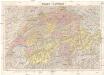
Carte physique & routière de la Suisse
1 : 500000 1 Karte dressés d'après des meilleurs matériaux par Jean Goll ; gravée par [Henri Louis Nicolas] Duval & [Rinaldo] Bressanini Henri Fuessli & Cie., Zürich
Carte de la république des Suisses, où sont distingués les 13 cantons et leurs alliés, les sujets de ces cantons et ceux de leurs alliés
1 Karte par Robert de Vaugondy ; Groux [Verlag nicht ermittelbar], [Paris]
Atlas für die Heimathskunde der Schweiz
1 : 19000000 1 Atlas (12, 12 Bl.) von J.S. Gerster ; gestochen von R. Leuzinger Dalp, Bern
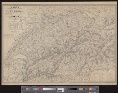
Die Schweiz, oder, Helvetische Eidgenossenschaft
1 : 586000 Švýcarsko Weiland, Karl Ferdinand Geograph. Instituts
Atlas für die Heimathskunde der Schweiz
1 : 19000000 1 Atlas (12, 12 Bl.) von J.S. Gerster ; gestochen von R. Leuzinger Dalp, Bern
Karte der Schweiz
1 : 650000 1 Karte entworfen und gestochen von J.H. Bachofen Verlag in J.H. Lochers Buchhandlung, Zürich
Postkarte der schweizerischen Eidgenossenschaft
1 : 300000 1 Karte offizielle Ausgabe durch das Post- und Bau-Departement und unter Aufsicht des General Dufour nach den gegenwärtig vorhandenen Materialien des eidgenössischen Atlasses und den besten Karten gezeichnet von J. R. Stengel u. E. Mohr Wurster, Winterthur
Karte der Posten, Telegraphen und Eisenbahnen der Schweizerischen Eidgenossenschaft
1 : 300000 Jent & Gassmann
Karte der Schweiz
1 : 400000 Leuzinger, Rudolf Schmid, Francke & Co.
Carte de la Suisse pour les écoles
1 : 700000 1 Karte R. Leuzinger Verlag der J. Dalp'schen Buch & Kunsthandlung (Carl Schmid), Bern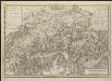
Carte nouvelle de la Suisse avec les routes des voyages faites en 1776, 1779, 1785 & 1786 par William Coxe, A.M.
Dl. Veelwaard, sculp. Amstelodam à Utrecht [etc.] : chèz B. Wild & J. Altheer [etc.]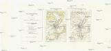
Carte nationale de la Suisse
1 : 25000 Švýcarsko Service topographique fédéral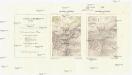
Landeskarte der Schweiz
1 : 25000 Švýcarsko Eidgenössische Landestopographie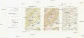
Carte nationale de la Suisse
1 : 50000 Švýcarsko Service topographique fédéral
[Carte topographique de la Suisse]
1 : 50000 Švýcarsko Service topographique féderal
[Carte della Suisse topografia]
1 : 50000 Švýcarsko Ufficio topografia federale
Atlas für die Heimathskunde der Schweiz
1 : 19000000 1 Atlas (12, 12 Bl.) von J.S. Gerster ; gestochen von R. Leuzinger Dalp, Bern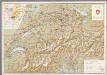
[Kaart], uit: Tourist map of Switzerland / Kümmerly & Frey
1 : 450000 Kümmerly + Frey, Bern Berne : Swiss Federal Railways
Reise-Karte der Schweiz
1 : 400000 1 Karte gez. v. Bollmann ; gest. von J. B. Seitz u. C. Schleich Verlag der J. G. Cotta'schen litterarisch-artistischen Anstalt, München
Relief-Karte der Schweiz
1 : 530000 Leuzinger, Rudolf Schmid, Francke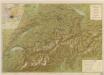
Suisse
Karte der Schweiz
1 : 400000 1 Karte von R. Leuzinger ; Schrift von Ch. v. Hoven chez J. Dalp (C. Schmid), Berne
La Suisse
1 Karte : Kupferdruck ; 43 x 54 cm Bonne; Santini G. A. Remondini?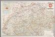
[Recto], uit: Tourist map of Switzerland
1 : 600000 Berne [etc.] : Swiss National Tourist Office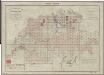
Topographischer Atlas der Schweiz (Siegfried-Karte): Den Kanton Zürich betreffende Blätter: Übersicht der Blätter
Leitung: Siegfried, Hermann (1819-1879), Topograf und Kartograf, von Zofingen AG; Eidgenössisches Topographisches Bureau, in Bern
<<Die>> Schweiz
1 : 1300000 1 Karte [W.E.A. von Schlieben] [W.E.A. von Schlieben], [Leipzig]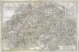
Carte de la Suisse ou l'on a marqué les routes suivies par M.re Wil. Coxe
1 Karte auf 2 Blatt : Kupferdruck ; 45 x 69 cm Coxe s.n.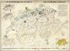
Die Industrien der Schweiz

[Karte der Schweiz]
1 Karte : Kupferdruck ; 16 x 20 cm Heidegger; Halder s.n.