Maps of Switzerland
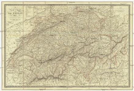
Carte physique et routiere de la Suisse
1 : 500000 Švýcarsko Andriveau-Goujon, J. J. Andriveau-Goujon
Historisch-Geographischer Atlas der Schweiz in 15 Blättern
1 : 770000 Konfessionelle Gestaltung der Schweiz 1652 - 1718 Voegelin, Johann Conrad ; Meyer von Knonau, Gerold ; Wyss, Georg von ; Meyer von Knonau, Gerold Schulthess
Nouvelle Carte Géographique de la Suisse : Contenant les Cantons de Berne, Fribourg, Soleurre, Basle, et les Terres de L'Evéque de Basle, avec leurs dépendances ...
Scheuchzer, Johann Jacob Wetstein und Smith
Historisch-Geographischer Atlas der Schweiz in 15 Blättern
1 : 770000 Eidgenossenschaft 1718 - 1798 Voegelin, Johann Conrad ; Meyer von Knonau, Gerold ; Wyss, Georg von ; Meyer von Knonau, Gerold Schulthess
Historisch-Geographischer Atlas der Schweiz in 15 Blättern
1 : 770000 Helvetische Republik 1798 - 1803 Voegelin, Johann Conrad ; Meyer von Knonau, Gerold ; Wyss, Georg von ; Meyer von Knonau, Gerold Schulthess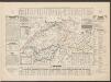
Historisch-Geographischer Atlas der Schweiz in 15 Blättern
1 : 770000 Helvetien um 450 Voegelin, Johann Conrad ; Meyer von Knonau, Gerold ; Wyss, Georg von ; Meyer von Knonau, Gerold Schulthess
Switzerland.
1 : 950400 Letts, Son & Co.
Tschudi's Schweizer-Karte für Reisende
1 : 814280 1 Karte Scheitlin u. Zollikofer, St. Gallen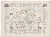
Geologische Spezialkarte des Grossherzogtums Baden, Blatt 144: Stühlingen: Karte XI: Politische Einteilung der zur Schweiz gehörigen Territorien im 18. Jahrhundert
Bearbeitung: Vögelin, J. K.; Meyer von Knonau, G.
Carte de la Republique des Suisses
1 Karte : Kupferdruck ; 47 x 59 cm Robert de Vaugondy; Groux G. et D. Robert de Vaugondy
Carte de la republique des Suisses
1 Karte : Kupferdruck ; 47 x 59 cm Robert de Vaugondy; Groux G. et D. Robert de Vaugondy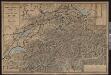
Sechste Wandkarte der Schweiz in 8 Blättern
1 : 200000 1 Karte in 4 Teilen H. Keller jun. ; Lith. von R. Leuzinger chez Hri. Keller, Zürich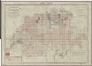
Topographischer Atlas der Schweiz (Siegfried-Karte): Den Kanton Zürich betreffende Blätter: Übersicht der Blätter
Leitung: Siegfried, Hermann (1819-1879), Topograf und Kartograf, von Zofingen AG; Eidgenössisches Topographisches Bureau, in Bern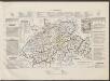
Historisch-Geographischer Atlas der Schweiz in 15 Blättern
1 : 770000 Helvetien 1037 - 1220 Voegelin, Johann Conrad ; Meyer von Knonau, Gerold ; Wyss, Georg von ; Meyer von Knonau, Gerold Schulthess
Die Schweiz
Geographischer Atlas über alle Theile der Erde Ziegler, Jakob Melchior Verlag von Dietrich Reimer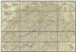
Deuxieme carte routiere de la Suisse
1 : 500000 Švýcarsko Keller, H. Stucchi
Die Schweiz, oder, Helvetische Eidgenossenschaft
1 : 586000 Švýcarsko Weiland, Karl Ferdinand Geograph. Instituts
Atlas über die Entwicklung von Industrie und Handel der Schweiz in dem Zeitraume vom Jahr 1770 bis zum Jahr 1870
1 : 500000 1 Atlas ([3], VIII Bl.) im Auftrage der schweizerischen Commission für die additionellen Ausstellungen in Wien, bearbeitet von Dr. Hermann Wartmann Wurster Randegger & Co., Winterthur
Oro-hydrographische Karte der Schweiz
1 : 600000 1 Karte bearb. von J. Randegger Wurster, Randegger & Co., Winterthur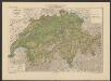
[Allgemeine Uebersichtkarte des Schweiz. Kulturbodens]
1 : 600000 Die Viehzucht und Milchwirthschaft der Schweiz Anderegg, Felix Verlag von J. Wurster & Comp. Landkartenhandlung
Nouvelle carte-routière de la Suisse
1 : 520000 1 Karte par Ed. Beck = Neue Eisenbahn- und Reise-Karte der Schweiz / von Ed. Beck Ed. Beck (Spitalgasse No. 141), Bern
Deuxième carte routière de la Suisse pour velocipédistes
1 : 445000 1 Karte Müllhaupt, Berne
[Schweiz]
1 : 770000 1 Karte [Keller?], [Zürich?]
Karte der Schweiz
1 : 600000 1 Karte bearb. unter Mitwirkung hervorragender Schulmänner von J. Randegger Topogr. Anst. v. Wurster, Randegger u. Co., Winterthur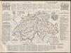
Historisch-Geographischer Atlas der Schweiz in 15 Blättern
1 : 770000 Kirchliche Einteilung der Schweiz Voegelin, Johann Conrad ; Meyer von Knonau, Gerold ; Wyss, Georg von ; Meyer von Knonau, Gerold Schulthess
La Suisse
1 Karte : Kupferdruck ; 43 x 54 cm Bonne; Santini G. A. Remondini?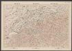
Suisse
1 : 600000 Topographische Anstalt Winterthur J. Schlumpf Topogr. Anstalt Winterthur, J. Schlumpf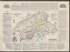
Historisch-Geographischer Atlas der Schweiz in 15 Blättern
1 : 770000 Politische Einteilung der Schweiz um 1750 Voegelin, Johann Conrad ; Meyer von Knonau, Gerold ; Wyss, Georg von ; Meyer von Knonau, Gerold Schulthess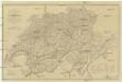
Carte physique et routiere de la Suisse
1 : 700000 Švýcarsko Starling, Thomas Virtue, George George Virtue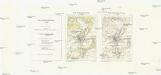
Carte nationale de la Suisse
1 : 25000 Švýcarsko Service topographique fédéral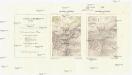
Landeskarte der Schweiz
1 : 25000 Švýcarsko Eidgenössische Landestopographie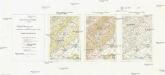
Carte nationale de la Suisse
1 : 50000 Švýcarsko Service topographique fédéral
[Carte topographique de la Suisse]
1 : 50000 Švýcarsko Service topographique féderal