Maps of Switzerland

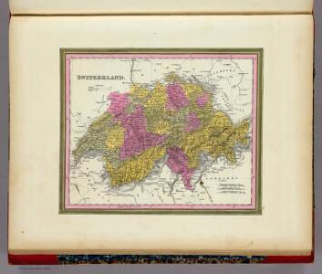
Switzerland.
1 : 1280000 Mitchell, Samuel Augustus
La Suisse.
1 : 980000 Clouet, J. B. L. (Jean-Baptiste Louis), b. 1730

[Karte der Schweiz]
1 Karte : Kupferdruck ; 16 x 20 cm Heidegger; Halder s.n.
La Suisse
1 Karte : Kupferdruck ; 43 x 54 cm Bonne; Santini G. A. Remondini?
Suisse.
1 : 795000 Migeon, J.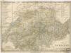
Die Schweiz

Die Helvetische Republik in Cantone und Districte eingetheilt
1 Karte : Typometrie ; 36 x 49 cm Haas gedruckt bey Wilhelm Haas dem Sohne
Die Schweiz
E. von Sydow's Schul-Atlas in sechs und dreissig Karten Sydow, Emil von bei Justus Perthes
Die Schweiz
Stieler, Adolf
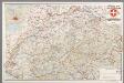
Geologische Karte der Schweiz
1 : 500000 Švýcarsko Leuzinger, Rudolf Kommisionverlag von A. Francke
Nouvelle carte itinéraire dressée pour servir de guide aux voyageurs dans les XXII cantons de la Confédération Suisse = Neue Reise Karte verfertiget zum Behuf des Wegweisers durch die XXII Kantone der schweizerischen Eidgenossenschaft
1 : 700000 titelvariant: Neue Reise Karte verfertiget zum Behuf des Wegweisers durch die XXII Kantone der schweizerischen Eidgenossenschaft; Annotatie geografische gegevens: Met legenda en hoogtentabel Weiss, H. (fl. 1820) Á Berne : publié par I.I. Bourgdorfer
Umriss von der Schweiz nach der neuen Eintheilung von 1798
1 Karte : Kupferdruck ; 36 x 48 cm s.n.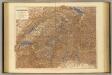
Switzerland.
1 : 506880 Stanford, Edward
[Recto], uit: Tourist map of Switzerland
1 : 600000 Berne [etc.] : Swiss National Tourist Office
Switzerland.
1 : 835000 Sharpe, J.

Carte physique & routière de la Suisse
1 : 500000 1 Karte dressés d'après des meilleurs matériaux par Jean Goll ; gravée par [Henri Louis Nicolas] Duval & [Rinaldo] Bressanini Henri Fuessli & Cie., Zürich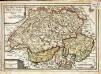
Les XIII. cantons des Suisses leurs alliez et leurs sujets
1 Karte : Kupferdruck ; 22 x 32 cm Fer; Inselin chez l'auteur dans l'isle du Palais a la sphere royale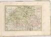

Die Schweiz
Stieler's Hand-Atlas Stieler, Adolf bei Justus Perthes
Atlas für die Heimathskunde der Schweiz
1 : 19000000 1 Atlas (12, 12 Bl.) von J.S. Gerster ; gestochen von R. Leuzinger Dalp, Bern
Carte nationale de la Suisse
1 : 25000 Švýcarsko Service topographique fédéral
Landeskarte der Schweiz
1 : 25000 Švýcarsko Eidgenössische Landestopographie
Carte nationale de la Suisse
1 : 50000 Švýcarsko Service topographique fédéral
[Carte topographique de la Suisse]
1 : 50000 Švýcarsko Service topographique féderal
[Carte della Suisse topografia]
1 : 50000 Švýcarsko Ufficio topografia federale
Carte de la république des Suisses, où sont distingués les 13 cantons et leurs alliés, les sujets de ces cantons et ceux de leurs alliés
1 Karte par Robert de Vaugondy ; Groux [Verlag nicht ermittelbar], [Paris]