Maps of Saarland
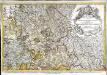
Le pays Messin, partie du temporel de l'evesché de Metz et partie du balliage allemand, dans le duché de Lorraine
1 Karte : Kupferdruck ; 44 x 68 cm Jaillot Alexis-Hubert Jaillot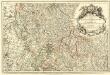
Les Estats du Duc de Lorraine ou sont les Duchez de Lorraine et de Bar :
1 : 180000 Mollova mapová sbírka Jaillot, Alexis-Hubert Jaillot, Alexis Hubert
Mediomatrici
1 Karte : Kupferdruck ; 44 x 51 cm Sanson; Robert de Vaugondy chez l'auteur, chés le Sr. Robert geog. ord. du roi quai de l'horloge
Archid.conné de Sarbovrg dans l'Evesché de Metz
1 : 240000 Mollova mapová sbírka Sanson, Nicolas Mariette, Pierre Sanson, Nicolas
Mediomatrici
1 Karte : Kupferdruck ; 43 x 50 cm Sanson chez l'auteur
Die Grenzen des Saargebietes nach dem Wortlaut des Friedensvertrages vom 25. 6. 1919
1 : 100000
Trier 112, uit: Special-Karte von Mittel-Europa / nach amtlichen Quellen bearbeitet von W. Liebenow
1 : 300000 titelvariant: W. Liebenow's Mittel-Europa; Annotatie: Titel boven de bladen: W. Liebenow's Mittel-Europa Johannes Wilhelm Liebenow 1822-1897 Frankfurt a. M. : Ludwig Ravenstein
Sbírka map a diagramů použitých na mírových konferencích v Paříži v letech 1919 - 1920

Trier 112, uit: [W. Liebenow's Special-Karte von Mittel-Europa]
1 : 300000 titelvariant: W. Liebenow's Mittel-Europa; Annotatie: Titel boven de bladen: W. Liebenow's Mittel-Europa Johannes Wilhelm Liebenow 1822-1897 Hannover : Hermann Oppermann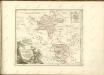

Obszar zagłębia Saary
Deutschland Frankreich Saargebiet Grenze Wierzbicki, B.
141 Metz.
1 : 86400 Cassini family; Cassini, Cesar-Francois, 1714-1784
[Metz]
1 Blatt : 60 x 91 cm s.n.
Le Flambeau de la Guerre Allumee au Rhin
Mollova mapová sbírka Delisle, Guillaume Schenk, Peter II
159. Saarbrücken, uit: Topographische Uebersichtskarte des Deutschen Reiches / herausgegeben v. d. Kartogr. Abt. d. Königl. Preuß. Landesaufnahme
1 : 200000 titelvariant: Topogr. Übersichtskarte des Deutschen Reiches; Annotatie: Titel boven bladen ook: Topogr. Übersichtskarte des Deutschen Reiches; Annotatie geografische gegevens: Op elk blad twee maatstokken: 10 Kilometer = 5,5 cm; 1 geogr. Meile = 3,6 cm; Legenda onder op elk blad Königlich Preußische Landesaufnahme. Kartographische Abtheilung [S.l : Königlich Preußische Landesaufnahme, Kartographische Abtheilung]
Partie Meridionale Des Pays Qui Sont Situéz Entre Le Rhein, La Saare, La Moselle Et La Basse Alsace
1 : 150000 Mollova mapová sbírka Mortier, Pieter Covens, Johannes I
Le Flambeau de la Guerre Allumee au Rhin
Mollova mapová sbírka Delisle, Guillaume Schenk, Peter II
Atlas zu der geognostischen Beschreibung des Landes, zwischen der untern Saar und dem Rheine
1 : 100000 Südwest-Blatt Steininger, Johann Verlag der Lintz'schen Buchhandlung
Geometrische Karte über das OberAmt Zweybrücken nebst dem dazu gehoerigen Amte Homburg
Bechstatt, I. C.
Territorium Metense
1 : 67000
Territorivm Metense
1 Karte : Kupferdruck ; 36 x 47 cm Fabert; Schenk; Valck apud G. Valk et P. Schenk
Territorivm Metense
1 Karte : Kupferdruck ; 37 x 48 cm Fabert; Blaeu; Blaeu apud Guiljelmum et Johannem Blaeuw
Nova territorii Metensis descriptio
1 Karte : Kupferdruck ; 35 x 45 cm Fabert; Hondius; Hondius excusum apud Iodocum et Henricum Hondium fratres
Messin Nova Territorii Metensis Descriptio [Karte], in: Gerardi Mercatoris et I. Hondii Newer Atlas, oder, Grosses Weltbuch, Bd. 2, S. 44.
1 Karte aus Atlas Mercator, Gerhard und Hondius, Jodocus Jansson, Jan
Le Flambeau de la Guerre Allumee au Rhin
Mollova mapová sbírka Delisle, Guillaume Schenk, Peter II

Schlacht bei Colombey-Nouilly
1 : 25000 Mety (Francie)
Meßtischblatt 3570 : Bitsch, 1883
1 : 250000 Bitsch. - Aufn. 1882. - 1:25000. - [Berlin]: Reichsamt für Landesaufnahme, 1883. - 1 Kt.
Meßtischblatt 6909 : Rohrbach b. Bitsch, 1942
1 : 250000 Rohrbach b. Bitsch. - Hrsg. 1883, Ausg. 1942 - 1:25000. - [Berlin]: Preußische Landesaufnahme, Hauptvermessungsabt. XI, 1942. - 1 Kt.


