Maps of Forbach-Boulay-Moselle
141 Metz.
1 : 86400 Cassini family; Cassini, Cesar-Francois, 1714-1784
[Metz]
1 Blatt : 60 x 91 cm s.n.
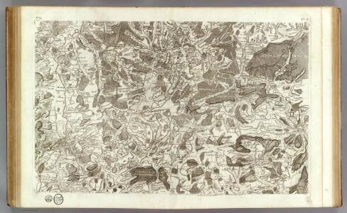
Le Flambeau de la Guerre Allumee au Rhin
Mollova mapová sbírka Delisle, Guillaume Schenk, Peter II
159. Saarbrücken, uit: Topographische Uebersichtskarte des Deutschen Reiches / herausgegeben v. d. Kartogr. Abt. d. Königl. Preuß. Landesaufnahme
1 : 200000 titelvariant: Topogr. Übersichtskarte des Deutschen Reiches; Annotatie: Titel boven bladen ook: Topogr. Übersichtskarte des Deutschen Reiches; Annotatie geografische gegevens: Op elk blad twee maatstokken: 10 Kilometer = 5,5 cm; 1 geogr. Meile = 3,6 cm; Legenda onder op elk blad Königlich Preußische Landesaufnahme. Kartographische Abtheilung [S.l : Königlich Preußische Landesaufnahme, Kartographische Abtheilung]
Territorium Metense
1 : 67000
Territorivm Metense
1 Karte : Kupferdruck ; 36 x 47 cm Fabert; Schenk; Valck apud G. Valk et P. Schenk
Territorivm Metense
1 Karte : Kupferdruck ; 37 x 48 cm Fabert; Blaeu; Blaeu apud Guiljelmum et Johannem Blaeuw
Nova territorii Metensis descriptio
1 Karte : Kupferdruck ; 35 x 45 cm Fabert; Hondius; Hondius excusum apud Iodocum et Henricum Hondium fratres
Territorium Metense [...] Le Pais Messin. [Karte], in: Novus Atlas, das ist, Weltbeschreibung, Bd. 2, S. 71.
1 Karte aus Atlas Blaeu, Joan Blaeu, Willem Janszoon
Messin Nova Territorii Metensis Descriptio [Karte], in: Gerardi Mercatoris et I. Hondii Newer Atlas, oder, Grosses Weltbuch, Bd. 2, S. 44.
1 Karte aus Atlas Mercator, Gerhard und Hondius, Jodocus Jansson, Jan
TERRITORIVM | METENSE
Auctore | AB. FABERT | Consule urbis | Metensis | LE PAIS | MESSIN Amsterdami | Apud Guiljelmum et | Johannem Blaeuw
Territorivm Metense
1 : 160000 Mollova mapová sbírka Fabert, Abraham Schenk, Peter I

Schlacht bei Colombey-Nouilly
1 : 25000 Mety (Francie)
Die Kriegsoperationen um Metz im Jahr 1870
1 : 50000 Algermissen, Johann Ludwig [s.n.]
Meßtischblatt 3565 : Falkenberg in Lothringen, 1916
1 : 250000 Falkenberg in Lothringen. - Aufn. 1881, hrsg. 1883, Aufldr. 1916. - 1:25000. - [Berlin]: Reichsamt für Landesaufnahme, 1916. - 1 Kt.
Meßtischblatt 6903 : Verny, 1882
1 : 250000 Verny. - Aufn. 1880. - 1:25000. - [Berlin]: Reichsamt für Landesaufnahme, 1882. - 1 Kt.
Meßtischblatt 6903 : Verny, 1876
1 : 250000 Verny. - Aufn. 1857. - 1:25000. - [Berlin]: Reichsamt für Landesaufnahme, 1876. - 1 Kt.
Meßtischblatt 3556 : Forbach, 1936
1 : 250000 Forbach. - Hrsg. 1883, bericht. 1929, einzelne Nachtr. 1936. - 1:25000. - Berlin: Reichsamt für Landesaufnahme, 1936. - 1 Kt.
Meßtischblatt 3555 : St. Avold, 1936
1 : 250000 St. Avold. - Hrsg. 1883, bericht. 1929, [gedr. 19]36. - 1:25000. - [Berlin]: Reichsamt für Landesaufnahme, 1936. - 1 Kt.
Meßtischblatt 3554 : Lubeln, 1916
1 : 250000 Lubeln. - Aufn. 1881, hrsg. 1883, B 08, N 13, Auflagendr. 1916. - 1:25000. - [Berlin]: Reichsamt für Landesaufnahme, 1916. - 1 Kt.
Meßtischblatt 3553 : Bolchen, 1916
1 : 250000 Bolchen. - Aufn. 1881, hrsg. 1883, B 08, Auflagendr. 1916. - 1:25000. - [Berlin]: Reichsamt für Landesaufnahme, 1916. - 1 Kt.
Meßtischblatt 6707 : Saarbrücken, 1940
1 : 250000 Saarbrücken. - Aufn. 1880/1930 - 32, hrsg. 1882, bericht. 1908,. - 1:25000. - [Berlin]: Reichsamt für Landesaufnahme, 1940. - 1 Kt.
Meßtischblatt 3548 : Saarbrücken, 1934
1 : 250000 Saarbrücken. - Aufn. 1880, bericht. 1908, Nachtr. 1921, hsrg. 1934. - 1:25000. - [Berlin]: Reichsamt für Landesaufnahme, 1934. - 1 Kt.
Meßtischblatt 3548 : Saarbrücken, 1921
1 : 250000 Saarbrücken. - Aufn. 1880, bericht. 1908, kl. Nachtr. 1921. - 1:25000. - [Berlin]: Reichsamt für Landesaufnahme, 1921. - 1 Kt.
Meßtischblatt 6707 : Saarbrücken, 1882
1 : 250000 Saarbrücken. - Aufn. 1880. - 1:25000. - [Berlin]: Reichsamt für Landesaufnahme, 1882. - 1 Kt.
Meßtischblatt 6706 : Ludweiler, 1882
1 : 250000 Ludweiler. - Aufn. 1880. - 1:25000. - [Berlin]: Reichsamt für Landesaufnahme, 1882. - 1 Kt.
Meßtischblatt 6705 : Busendorf (Westmark), 1942
1 : 250000 Busendorf (Westmark). - Aufn. 1880, hrsg. 1882, bericht./letzte Nachtr. - 1:25000. - [Berlin]: Reichsamt für Landesaufnahme, 1942. - 1 Kt.
Meßtischblatt 3545 : Gelmingen, 1917
1 : 250000 Gelmingen. - Aufn. 1880, hrsg. 1882, B 08, Aufldr. 1917. - 1:25000. - [Berlin]: Reichsamt für Landesaufnahme, 1917. - 1 Kt.