Maps of Wales

Wallia principatvs vulgo Wales
1 Karte : Kupferdruck ; 37 x 48 cm Blaeu Joan Blaeu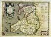
Cambriae typus
1 Karte : Kupferdruck ; 33 x 48 cm Lhuyd; Keere; Mercator; Hondius Henricus Hondius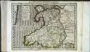
Cambriae typus
1 Karte : Kupferdruck ; 17 x 24 cm Lhuyd; Keere; Mercator Cloppenburgh
Cambriae typvs
1 Karte : Kupferdruck ; 35 x 47 cm Lhuyd; Ortelius s.n.
Cambriae typvs
1 Karte : Kupferdruck ; 35 x 47 cm Lhuyd; Ortelius s.n.
Wales.
1 : 395000 Hughes, William
WALLIA | PRINCIPATVS | Vulgo WALES.
[Amsterdam : Joan Blaeu]
England II.
1 : 765000 Society for the Diffusion of Useful Knowledge (Great Britain)
CUMBRIAE TYPUS auctore HVMFREDO LHVYD, Denbigiense Cambrobritanno
This is a map of Wales by Humpfry Lyde, after Ortelius. It forms part of an atlas that belonged to William Cecil Lord Burghley, Elizabeth I’s Secretary of State. Burghley used this atlas to illustrate domestic matters. Lyde, Humpfry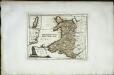
Das Fürstenthum Wales
1 Karte : Kupferdruck ; 19 x 26 cm Reilly F. J. J. von Reilly
Wallia Principatus Vulgo Wales. [Karte], in: Le théâtre du monde, ou, Nouvel atlas contenant les chartes et descriptions de tous les païs de la terre, Bd. 4, S. 336.
1 Karte aus Atlas Blaeu, Willem Janszoon und Blaeu, Joan Blaeu, Willem Janszoon
Cambriae typus
1 : 780000

Wallia Principatus Vulgo Wales. [Karte], in: Theatrum orbis terrarum, sive, Atlas novus, Bd. 4, S. 390.
1 Karte aus Atlas Blaeu, Joan Blaeu, Willem Janszoon
Wallia Principatus Vulgo Wales. [Karte], in: Theatrum orbis terrarum, sive, Atlas novus, Bd. 4, S. 390.
1 Karte aus Atlas Blaeu, Joan Blaeu, Willem Janszoon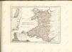

Principatus Walliae Pars Borealis vulgo North Wales
1 : 390000 Amstelodami : apud Joannem Janssonium
Principatus Walliae Pars Borealis Vulgo North Wales. [Karte], in: Novus atlas absolutissimus, Bd. 8, S. 8.
1 Karte aus Atlas Janssonius Offizin
Principatus Walliae Pars Australis: Vulgo South-Wales. [Karte], in: Novus atlas absolutissimus, Bd. 7, S. 371.
1 Karte aus Atlas Janssonius Offizin
Principatus Walliae Pars Australis vulgo South-Wales
1 : 460000 Amstelodami : apud Joannem Janssonium
Watershed map England, Wales 3.
1 : 760320 Letts, Son & Co.
England and Wales 1:253,440
Ordnance Survey
An accurate map of North Wales
1 Karte : Kupferdruck ; 50 x 66 cm Tinney; Bowles; Sayer; Bowles; Bowles printed for T. Bowles in St. Pauls Church Yard John Tinney and Rob.t Sayer in Fleet street and John Bowles and son in Cornhil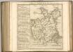

RADNOR, BREKNOK, Cardigan et Caermarden
This is a map of Radnor, Brecknock, Cardigan and Caermarthen by Christopher Saxton which dates from 1578. It forms part of an atlas that belonged to William Cecil Lord Burghley, Elizabeth I’s Secretary of State. Burghley used this atlas to illustrate domestic matters. This map is actually a proof copy of one which forms part of Christopher Saxton’s Atlas of England and Wales. This atlas was first published as a whole in 1579. It consists of 35 coloured maps depicting the counties of England and Wales. The atlas is of great significance to British cartography as it set a standard of cartographic representation in Britain and the maps remained the basis for English county mapping, with few exceptions, until after 1750. During the reign of Elizabeth I map use became more common, with many government matters referring to increasingly accurate maps with consistent scales and symbols, made possible by advances in surveying techniques. Illustrating the increasing use of maps in government matters, Lord Burghley, who had been determined to have England and Wales mapped in detail from the 1550s, selected the cartographer Christopher Saxton to produce a detailed and consistent survey of the country. The financier of the project was Thomas Seckford, Master of Requests at the Court of Elizabeth I, whose arms appear, along with the royal crest, on each map. Burghley has annotated this map, adding place names. At this time England was under threat of invasion from Catholic Spain, a threat which culminated in the events of the Spanish Armada. Defence of the realm depended on a good geographic and topographic knowledge, explaining Burghley's use of maps and his annotation of them. The map was engraved by one of a team of seven English and Flemish engravers employed to produce the copper plates for the atlas, although the individual engraver is not noted. Saxton, Christopher William Cecil, Lord Burghley
RADNOR BREKNOK Cardigan et Caermarden
This map of Radnor,Cardigan, Carmarthenshire and Brecknonshire, from the 1583 edition of the Saxton atlas of England and Wales.This atlas was first published as a whole in 1579. It consists of 35 coloured maps depicting the counties of England and Wales. The atlas is of great significance to British cartography as it set a standard of cartographic representation in Britain and the maps remained the basis for English county mapping, with few exceptions, until after 1750. During the reign of Elizabeth I map use became more common, with many government matters referring to increasingly accurate maps with consistent scales and symbols, made possible by advances in surveying techniques. Illustrating the increasing used of maps in government matters, Lord Burghley, Elizabeth I’s Secretary of State, who had been determined to have England and Wales mapped in detail from the 1550s, selected the cartographer Christopher Saxton to produce a detailed and consistent survey of the country. The financier of the project was Thomas Seckford Master of Requests at the Court of Elizabeth I, whose arms appear, along with the royal crest, on each map. Saxton, Christopher Ryther, Augustine
delineation of the strata of England and Wales, with part of Scotland
1 : 320000 Blatt 6 Smith, William Cary
Comitatus Caernarvoniensis; Vernacule Carnarvon-Shire. et Mona Insula Vulgo Anglesey. [Karte], in: Theatrum orbis terrarum, sive, Atlas novus, Bd. 4, S. 429.
1 Karte aus Atlas Blaeu, Joan Blaeu, Willem Janszoon
Penbrochia Comitatus et Comitatus Caermaridunum. [Karte], in: Le théâtre du monde, ou, Nouvel atlas contenant les chartes et descriptions de tous les païs de la terre, Bd. 4, S. 358.
1 Karte aus Atlas Blaeu, Willem Janszoon und Blaeu, Joan Blaeu, Willem Janszoon


