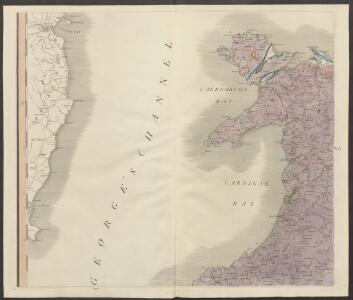
Maps of Gwynedd

delineation of the strata of England and Wales, with part of Scotland
1 : 320000 Blatt 6 Smith, William Cary
Sheet 4 North Wales, uit: Maps of England & Wales : scale 4 miles to 1 inch / Ordnance Survey
1 : 253440 titelvariant: Maps of England and Wales; Annotatie: Titel op cassette; Met bladoverzicht op de achterzijde van de cassette; Annotatie geografische gegevens: Hoogtelijneninterval 200 ft Ordnance Survey, United Kingdom Southampton : Ordnance Survey Office
Principatus Walliae Pars Borealis Vulgo North Wales. [Karte], in: Novus atlas absolutissimus, Bd. 8, S. 8.
1 Karte aus Atlas Janssonius Offizin
An accurate map of North Wales
1 Karte : Kupferdruck ; 50 x 66 cm Tinney; Bowles; Sayer; Bowles; Bowles printed for T. Bowles in St. Pauls Church Yard John Tinney and Rob.t Sayer in Fleet street and John Bowles and son in Cornhil
Een gedeelte van de Oost kust van IJrlandt van Wexfort tot t eijlandt Dalkij
Ireland Gerard van Keulen
Comitatus Caernarvoniensis; Vernacule Carnarvon-Shire, et Mona Insula Vulgo Anglesey. [Karte], in: Le théâtre du monde, ou, Nouvel atlas contenant les chartes et descriptions de tous les païs de la terre, Bd. 4, S. 369.
1 Karte aus Atlas Blaeu, Willem Janszoon und Blaeu, Joan Blaeu, Willem Janszoon
Comitatus Caernarvoniensis; Vernacule Carnarvon-Shire. et Mona Insula Vulgo Anglesey. [Karte], in: Theatrum orbis terrarum, sive, Atlas novus, Bd. 4, S. 429.
1 Karte aus Atlas Blaeu, Joan Blaeu, Willem Janszoon
Comitatus Caernarvoniensis; Vernacule Carnarvon-Shire. et Mona Insula Vulgo Anglesey. [Karte], in: Theatrum orbis terrarum, sive, Atlas novus, Bd. 4, S. 429.
1 Karte aus Atlas Blaeu, Joan Blaeu, Willem Janszoon
COMITATVS | CAERNARVO- | NIENSIS; | Vernacule | CARNARVON-SHIRE. | ET | MONA INSVLA | Vulgo | ANGLESEY.
[Amsterdam : Joan Blaeu]
Comitatvs Caernarvoniensis; vernacule Carnarvon-Shire. et Mona insvla vulgo Anglesey
1 Karte : Kupferdruck ; 36 x 48 cm Blaeu Joan Blaeu
An accurate map of Cardigan Shire
1 Karte : Kupferdruck ; 33 x 52 cm Kitchin; Tinney John Tinney
Ceretica; sive Cardiganensis comitatus; anglis Cardigan Shire
1 Karte : Kupferdruck ; 36 x 48 cm Blaeu Joan Blaeu
Sheets 29-30. (Cary's England, Wales, and Scotland).
1 : 360000 Cary, John, ca. 1754-1835
Sheets 38-39. (Cary's England, Wales, and Scotland).
1 : 360000 Cary, John, ca. 1754-1835
North Wales, Sheet 11 - Bartholomew's "Half Inch to the Mile Maps" of England & Wales
1 : 126720 Topographic maps Bartholomew, John George John Bartholomew & Co
South Wales and the border in the 14th century
Rees, William Ordnance Survey
MONE INSULAE modo Anglesey et Caernaruan
This is a map of Anglesey and Caernarvon by Christopher Saxton dating from 1578. It forms part of an atlas that belonged to William Cecil Lord Burghley, Elizabeth I’s Secretary of State. Burghley used this atlas to illustrate domestic matters. This map is actually a proof copy of one which forms part of Christopher Saxton’s Atlas of England and Wales. This atlas was first published as a whole in 1579. It consists of 35 coloured maps depicting the counties of England and Wales. The atlas is of great significance to British cartography as it set a standard of cartographic representation in Britain and the maps remained the basis for English county mapping, with few exceptions, until after 1750. During the reign of Elizabeth I, map use became more common, with many government matters referring to increasingly accurate maps with consistent scales and symbols, made possible by advances in surveying techniques. Illustrating the increasing use of maps in government matters, Lord Burghley, who had been determined to have England and Wales mapped in detail from the 1550s, selected the cartographer Christopher Saxton to produce a detailed and consistent survey of the country. The financier of the project was Thomas Seckford, Master of Requests at the Court of Elizabeth I, whose arms appear, along with the royal crest, on each map. Burghley has annotated this map, adding place names to the map and notes about the shire towns of Denbigh in the margins. At this time England was under threat of invasion from Catholic Spain, a threat which culminated in the events of the Spanish Armada. Defence of the realm depended on a good geographic and topographic knowledge, explaining Burghley's use of maps and his annotation of them, particularly at locations along the coast. The map was engraved by one of a team of seven English and Flemish engravers employed to produce the copper plates for the atlas, although the individual name is not recorded. Saxton, Christopher Hogenbergius, Remigius
MONE INSULAE
This map of the isle of Man is from the 1583 edition of the Saxton atlas of England and Wales.This atlas was first published as a whole in 1579. It consists of 35 coloured maps depicting the counties of England and Wales. The atlas is of great significance to British cartography as it set a standard of cartographic representation in Britain and the maps remained the basis for English county mapping, with few exceptions, until after 1750. During the reign of Elizabeth I map use became more common, with many government matters referring to increasingly accurate maps with consistent scales and symbols, made possible by advances in surveying techniques. Illustrating the increasing used of maps in government matters, Lord Burghley, Elizabeth I’s Secretary of State, who had been determined to have England and Wales mapped in detail from the 1550s, selected the cartographer Christopher Saxton to produce a detailed and consistent survey of the country. The financier of the project was Thomas Seckford Master of Requests at the Court of Elizabeth I, whose arms appear, along with the royal crest, on each map. Saxton, Christopher Ryther, Augustine
Ceretica, sive Cardiganensis Comitatus, anglis Cardigan Shire
1 : 460000 Amstelodami : apud Joannem Janssonium
CERETICA; | sive | CARDIGANensis | Comitatus; Anglis | CARDIGAN SHIRE.
[Amsterdam : Joan Blaeu]
Ceretica; sive Cardiganensis Comitatus; Anglis Cardigan Shire. [Karte], in: Theatrum orbis terrarum, sive, Atlas novus, Bd. 4, S. 421.
1 Karte aus Atlas Blaeu, Joan Blaeu, Willem Janszoon
Ceretica; sive Cardiganensis Comitatus; Anglis Cardigan Shire. [Karte], in: Theatrum orbis terrarum, sive, Atlas novus, Bd. 4, S. 421.
1 Karte aus Atlas Blaeu, Joan Blaeu, Willem Janszoon
Sheet 37. (Cary's England, Wales, and Scotland).
1 : 360000 Cary, John, ca. 1754-1835

Ceretica; sive Cardiganensis Comitatus; Anglis Cardigan Shire. [Karte], in: Le théâtre du monde, ou, Nouvel atlas contenant les chartes et descriptions de tous les païs de la terre, Bd. 4, S. 363.
1 Karte aus Atlas Blaeu, Willem Janszoon und Blaeu, Joan Blaeu, Willem Janszoon
Mona Insula Vulgo Anglesey. [Karte], in: Novus atlas absolutissimus, Bd. 8, S. 104.
1 Karte aus Atlas Janssonius Offizin
Mona insula vulgo Anglesey ; Mona insula vulgo the Isle of Man ; Vectis insula anglice the Isle of Wight
Amstelodami : apud Joannem Janssonium
Ceretica; sive Cardiganensis Comitatus; Anglis Cardigan Shire. [Karte], in: Novus atlas absolutissimus, Bd. 7, S. 395.
1 Karte aus Atlas Janssonius Offizin
Anglesey - OS One-Inch Map
1 : 63360 Topographic maps Ordnance Survey Ordnance Survey