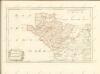
Maps of Anglesey

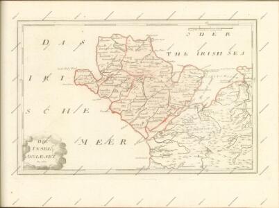
Mona insula vulgo Anglesey ; Mona insula vulgo the Isle of Man ; Vectis insula anglice the Isle of Wight
Amstelodami : apud Joannem Janssonium
Mona Insula Vulgo Anglesey. [Karte], in: Novus atlas absolutissimus, Bd. 8, S. 104.
1 Karte aus Atlas Janssonius Offizin
Anglesey - OS One-Inch Map
1 : 63360 Topographic maps Ordnance Survey Ordnance Survey
Anglesey. [Karte], in: Atlas, sive, Cosmographicae meditationes de fabrica mundi et fabricati figura, S. 125.
1 Karte aus Atlas Mercator, Gerhard
Anglesey. [Karte], in: Gerardi Mercatoris Atlas, sive, Cosmographicae meditationes de fabrica mundi et fabricati figura, S. 130.
1 Karte aus Atlas Mercator, Gerhard Montanus, Petrus
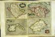
Anglesey
4 Karten auf einem Blatt : Kupferdruck ; je 15 x 21 cm, Bildgrösse 31 x 42 cm Mercator; Hondius Henricus Hondius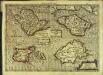
Anglesey
4 Karten auf 1 Blatt : Kupferdruck ; je 9 x 13 cm, Bildgrösse 18 x 25 cm Mercator Cloppenburgh
Anglesey
4 Karten auf einem Blatt : Kupferdruck ; je 15 x 20 cm, Bildgrösse 31 x 42 cm Mercator; Hondius Jodocus Hondius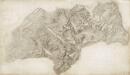
Caernarvon
1 : 31680 This drawing of Caernarfon Bay is formally titled in the top left margin. An area calculation table survives in black ink with the area surveyed totalling 160;184.1761 square miles. Archaeological sites are named in gothic script. Colour washes depicting relief are combined with numerical annotations ('spot heights') in red ink, indicating the heights of hills. Pencil rays radiate from trigonometrical stations across the map. These were used for measuring and plotting topographical features. Dawson, Robert
Holyhead
1 : 31680 .This plan of north Angelsey runs from Holyhead Bay,on the left, to Red Wharf Bay,on the right., Black-ink numbers,are visible on high spots, indicating the,heights of hills., Archaeological details are noted in black gothic lettering. An area calculation table survives in black ink,in the top left margin. Dawson, Robert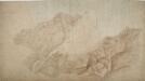
Conway
1 : 31680 This plan of the Menai Strait extends along the coastline of Conway Bay from Penmaenmawr to Conway. Triangles are ruled in ink and pencil across the map, allowing the location of individual topographical features to be plotted. Colour washes depicting relief are combined with numerical annotations ('spot heights') indicating the heights of the hills. The brown ink used for place names and heights has smudged, making legibility poor overall. An area calculation table survives in black ink in the top left margin, below the formal title. Dawson, Robert
Llangefni
1 : 31680 .This plan of south Anglesey,extends from,Cymran Bay to the Menai Strait on the left of the map, and inland to Llangefni,on the right. ,Black-ink numbers, visible on high spots, indicate the,height of hills., Archaeological details are recorded in black gothic lettering., An area calculation table survives in black ink,in the top left margin. The circular hole in the top right-hand corner,shows an,'Ordnance Office Copy' blind stamp has been removed from the manuscript. Dawson, Robert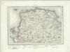
Holyhead (Outline) - OS One-Inch Revised New Series
1 : 63360 Topographic maps Ordnance Survey Ordnance Survey
Holyhead (Hills) - OS One-Inch Revised New Series
1 : 63360 Topographic maps Ordnance Survey Ordnance Survey
Carnarvon (Hills) - OS One-Inch Revised New Series
1 : 63360 Topographic maps Ordnance Survey Ordnance Survey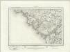
Carnarvon (Outline) - OS One-Inch Revised New Series
1 : 63360 Topographic maps Ordnance Survey Ordnance Survey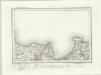
Beaumaris (Outline) - OS One-Inch Revised New Series
1 : 63360 Topographic maps Ordnance Survey Ordnance Survey
Beaumaris (Hills) - OS One-Inch Revised New Series
1 : 63360 Topographic maps Ordnance Survey Ordnance Survey
Bangor (Hills) - OS One-Inch Revised New Series
1 : 63360 Topographic maps Ordnance Survey Ordnance Survey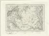
Bangor (Outline) - OS One-Inch Revised New Series
1 : 63360 Topographic maps Ordnance Survey Ordnance Survey
South Stack (Outline) - OS One-Inch Revised New Series
1 : 63360 Topographic maps Ordnance Survey Ordnance Survey
South Stack (Hills) - OS One-Inch Revised New Series
1 : 63360 Topographic maps Ordnance Survey Ordnance Survey
SH39 & Parts of SH29 - OS 1:25,000 Provisional Series Map
1 : 25000 Topographic maps Ordnance Survey Ordnance Survey
SH28 - OS 1:25,000 Provisional Series Map
1 : 25000 Topographic maps Ordnance Survey Ordnance Survey
SH27 - OS 1:25,000 Provisional Series Map
1 : 25000 Topographic maps Ordnance Survey Ordnance Survey
SH38 - OS 1:25,000 Provisional Series Map
1 : 25000 Topographic maps Ordnance Survey Ordnance Survey
SH37 - OS 1:25,000 Provisional Series Map
1 : 25000 Topographic maps Ordnance Survey Ordnance Survey