Maps of Wales

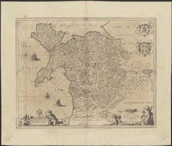
Principatus Walliae Pars Borealis vulgo North Wales
1 : 390000 Amstelodami : apud Joannem Janssonium
Watershed map England, Wales 3.
1 : 760320 Letts, Son & Co.
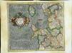
Cambriae typus
1 : 780000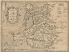
Cambriae Typus [Karte], in: Theatrum orbis terrarum, S. 86.
1 Karte aus Atlas Ortelius, Abraham Vrients, Jan Baptista
Wallia Principatus Vulgo Wales. [Karte], in: Theatrum orbis terrarum, sive, Atlas novus, Bd. 4, S. 390.
1 Karte aus Atlas Blaeu, Joan Blaeu, Willem Janszoon
CUMBRIAE TYPUS auctore HVMFREDO LHVYD, Denbigiense Cambrobritanno
This is a map of Wales by Humpfry Lyde, after Ortelius. It forms part of an atlas that belonged to William Cecil Lord Burghley, Elizabeth I’s Secretary of State. Burghley used this atlas to illustrate domestic matters. Lyde, Humpfry
Wallia Principatus Vulgo Wales. [Karte], in: Theatrum orbis terrarum, sive, Atlas novus, Bd. 4, S. 390.
1 Karte aus Atlas Blaeu, Joan Blaeu, Willem Janszoon
Wallia Principatus Vulgo Wales. [Karte], in: Le théâtre du monde, ou, Nouvel atlas contenant les chartes et descriptions de tous les païs de la terre, Bd. 4, S. 336.
1 Karte aus Atlas Blaeu, Willem Janszoon und Blaeu, Joan Blaeu, Willem Janszoon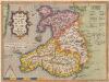
Cambriae Typus [...] [Karte], in: Theatrum orbis terrarum, S. 39.
1 Karte aus Atlas Ortelius, Abraham
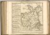
Principauté de Galles
1 Karte : Kupferdruck ; 36 x 42 cm Sanson; Fortin chez le Sr. Fortin ing.r pour les globes rue de la Harpe près celle du Foin
Principauté de Galles
1 Karte : Kupferdruck ; 36 x 42 Sanson chez l'autheur
England II.
1 : 765000 Society for the Diffusion of Useful Knowledge (Great Britain)
Cambriae Typus [Karte], in: Gerardi Mercatoris Atlas, sive, Cosmographicae meditationes de fabrica mundi et fabricati figura, S. 118.
1 Karte aus Atlas Mercator, Gerhard Montanus, Petrus

WALLIA | PRINCIPATVS | Vulgo WALES.
[Amsterdam : Joan Blaeu]
Principatus Walliae Pars Borealis Vulgo North Wales. [Karte], in: Novus atlas absolutissimus, Bd. 8, S. 8.
1 Karte aus Atlas Janssonius Offizin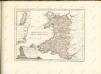
Westmorlandia, Lancastria, Cestria, Caernarvan, Denbigh, Flint, Merionidh, Montgomery, Salopia cum insulis Mania et Anglesey
1 Karte : Kupferdruck ; 34 x 40 cm Mercator; Hondius Henricus Hondius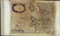
Westmorlandia, Lancastria, Cestria, Caernarvan, Denbigh, Flint, Merionidh, Montgomery, Salopia cum insulis Mania, et Anglesey
1 Karte : Kupferdruck ; 17 x 24 cm Mercator Cloppenburgh
Westmorlandia, Lancastria, Cestria, Caernarvan, Denbigh, Flint, Merionidh, Montgomery, Salopia cum insulis Mania et Anglesey
1 Karte : Kupferdruck ; 34 x 40 cm Mercator; Hondius Jodocus Hondius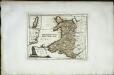
Das Fürstenthum Wales
1 Karte : Kupferdruck ; 19 x 26 cm Reilly F. J. J. von Reilly
Wallia principatvs vulgo Wales
1 Karte : Kupferdruck ; 37 x 48 cm Blaeu Joan Blaeu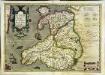
Cambriae typus
1 Karte : Kupferdruck ; 33 x 48 cm Lhuyd; Keere; Mercator; Hondius Henricus Hondius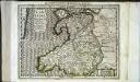
Cambriae typus
1 Karte : Kupferdruck ; 17 x 24 cm Lhuyd; Keere; Mercator Cloppenburgh
Cambriae typvs
1 Karte : Kupferdruck ; 35 x 47 cm Lhuyd; Ortelius s.n.
Cambriae typvs
1 Karte : Kupferdruck ; 35 x 47 cm Lhuyd; Ortelius s.n.

Wales.
1 : 395000 Hughes, William