Maps of Somerset

An improved map of the county of Somerset
1 Karte : Kupferdruck ; 51 x 68 cm Bowen; Hinton sold by I. Hinton at the Kings Arms in St. Pauls Church Yard
Somersettensis comitatvs
1 Karte : Kupferdruck ; 36 x 48 cm Valck; Schenk apud G. Valk et P. Schenk
Somersettensis comitatvs
1 Karte : Kupferdruck ; 37 x 48 cm Blaeu Joan Blaeu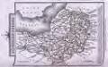
Cary's Traveller's Companion, or, a Delineation of the Turnpike Roads of England and Wales
London : G. & J. Cary
Somersettensis Comitatus = Somerset Shire
1 : 240000 Amstelodami : apud Joannem Janssonium
SOMERSET- | TENSIS | COMITATVS. | Somerset shire.
[Amsterdam : Joan Blaeu]

Somersettensis Comitatus: Somerset Shire [Karte], in: Novus atlas absolutissimus, Bd. 7, S. 179.
1 Karte aus Atlas Janssonius Offizin
SOMERSETENSEM Comitat.
This map of Somerset is from the 1583 edition of the Saxton atlas of England and Wales. This atlas was first published as a whole in 1579. It consists of 35 coloured maps depicting the counties of England and Wales. The atlas is of great significance to British cartography as it set a standard of cartographic representation in Britain and the maps remained the basis for English county mapping, with few exceptions, until after 1750. During the reign of Elizabeth I map use became more common, with many government matters referring to increasingly accurate maps with consistent scales and symbols, made possible by advances in surveying techniques. Illustrating the increasing used of maps in government matters, Lord Burghley, Elizabeth I’s Secretary of State, who had been determined to have England and Wales mapped in detail from the 1550s, selected the cartographer Christopher Saxton to produce a detailed and consistent survey of the country. The financier of the project was Thomas Seckford Master of Requests at the Court of Elizabeth I, whose arms appear, along with the royal crest, on each map. The decorative scale bar houses Saxton’s name and the name of the engraver Leonardus Terwoort, one of seven English and Flemish engravers employed to produced the copper plates for the atlas. Relief, in the form of uniform rounded representations of hills, is the main topographical feature presented in the maps. Rather than provide a scientific representation of relative relief these give a general impression of the lie of the land. Settlements and notable buildings are also recorded pictorially; a small building with a spire represents a village, while more important towns are indicated by groups of building. The county border are differentiated by different coloured shading. In neighbouring Wiltshire Longleat estate is marked. At the time this map was first engraved Longleat was still being built by Sir John Thynn and was not finished until 1580, the year after the maps publication. This perhaps is reflected in the somewhat modest appearance of the house and gardens? Saxton, Christopher Ryther, Augustine
Somersettensis Comitatus. Somerset shire. [Karte], in: Theatrum orbis terrarum, sive, Atlas novus, Bd. 4, S. 150.
1 Karte aus Atlas Blaeu, Joan Blaeu, Willem Janszoon
Somersettensis Comitatus. Somerset shire. [Karte], in: Le théâtre du monde, ou, Nouvel atlas contenant les chartes et descriptions de tous les païs de la terre, Bd. 4, S. 134.
1 Karte aus Atlas Blaeu, Willem Janszoon und Blaeu, Joan Blaeu, Willem Janszoon
Somersettensis Comitatus. Somerset shire. [Karte], in: Theatrum orbis terrarum, sive, Atlas novus, Bd. 4, S. 150.
1 Karte aus Atlas Blaeu, Joan Blaeu, Willem Janszoon
Comitatus Somersettensis Somerest-Shire. [Karte], in: Gerardi Mercatoris et I. Hondii Newer Atlas, oder, Grosses Weltbuch, Bd. 1, S. 84.
1 Karte aus Atlas Mercator, Gerhard und Hondius, Jodocus Jansson, Jan
Weston-Super-Mare - OS One-Inch Map
1 : 63360 Topographic maps Ordnance Survey Ordnance Survey
Cary's Improved Map of England and Wales
Cary, George, & Cary, John London : G. & J. Cary
Frome - OS One-Inch Map
1 : 63360 Topographic maps Ordnance Survey Ordnance Survey
Frome
This drawing highlights Bath and the River Avon. Major communication routes are coloured yellow/buff, according to military cartographic convention. Shading and 'hachuring' denote relief and give an overall impression of the undulating landscape. The Somerset Coal Canal is clearly visible leading into Bath. It was established by Act of Parliament in 1794 and welcomed by the mine owners of north Somerset as a cheaper way of transporting coal to Bath and the surrounding areas, curbing fears of an influx of Welsh coal. The canal was one of the most successful in the country, carrying over 100,000 tons of coal per year. That success was to be checked, however, by the expansion of the local rail network, in particular, the opening of the line between Radstock and Frome, which hastened the canal's closure in 1898. At the time of this survey, the canal was fully operational. Crocker, Edmund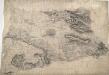
Glastonbury
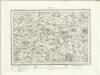
Pencil orientation lines can be seen around the edges of this drawing. An arrow protruding from Wells indicates the link-point between this and another drawing. The flat lands of Burtle Heath and Kings Sedge Moor occupy half the drawing. Field boundaries and the manmade drainage system are recorded. Toll gates are marked 'TG' along the main turnpike road from Shepton Mallet to Somerton, which forms the edge of the drawing.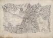
Wincanton
This drawing is rich in archaeological sites, the most notable being Cadbury Castle, which, according to legend, is the Camelot of Arthurian myth. It is marked by several concentric rings inside a band of dense shading, smudged at the top, indicating a steep mound. It was not until 1839-40 that contour lines were introduced into Ordnance Survey drawings, and so the two large blank areas on the map represent low fluvial tracts. Red pecked lines denote the boundaries between Dorset, Somerset and Wiltshire
Weston Super Mare (Hills) - OS One-Inch Revised New Series
1 : 63360 Topographic maps Ordnance Survey Ordnance Survey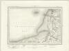
Weston Super Mare (Outline) - OS One-Inch Revised New Series
1 : 63360 Topographic maps Ordnance Survey Ordnance Survey
Taunton (Hills) - OS One-Inch Revised New Series
1 : 63360 Topographic maps Ordnance Survey Ordnance Survey
Taunton (Outline) - OS One-Inch Revised New Series
1 : 63360 Topographic maps Ordnance Survey Ordnance Survey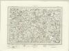
Wellington (Outline) - OS One-Inch Revised New Series
1 : 63360 Topographic maps Ordnance Survey Ordnance Survey
Wellington (Hills) - OS One-Inch Revised New Series
1 : 63360 Topographic maps Ordnance Survey Ordnance Survey
Wells (Hills) - OS One-Inch Revised New Series
1 : 63360 Topographic maps Ordnance Survey Ordnance Survey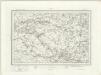
Wells (Outline) - OS One-Inch Revised New Series
1 : 63360 Topographic maps Ordnance Survey Ordnance Survey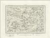
Glastonbury (Outline) - OS One-Inch Revised New Series
1 : 63360 Topographic maps Ordnance Survey Ordnance Survey
Glastonbury (Hills) - OS One-Inch Revised New Series
1 : 63360 Topographic maps Ordnance Survey Ordnance Survey
Yeovil (Hills) - OS One-Inch Revised New Series
1 : 63360 Topographic maps Ordnance Survey Ordnance Survey