Maps of North Somerset

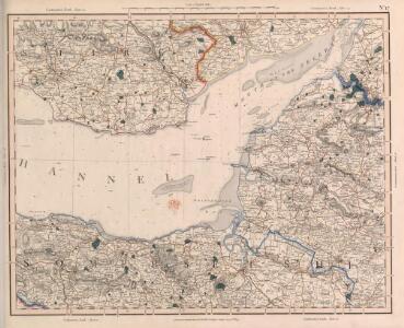
Cary's Improved Map of England and Wales
Cary, George, & Cary, John London : G. & J. Cary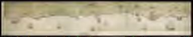
A coloured chart of "The coste of England uppon Severne," being the whole north coast of Somersetshire; with the forts erected thereon; temp. Henry VIII ca. 1540
This is a pictorial representation of the north coast of Somerset. It shows the coast from the mouth of the River Avon near East Bristol to west Porlock and can be dated to 1539. At the top of the drawing round towers represent proposed blockhouses in the neighbourhoods of Porlock and Western-super-Mare on the north coast of Somerset. The intention to mount guns on platforms at Minehead and to the north of the Parrat is also represented in this drawing. Inlets are indicated and towns are shown schematically, an emphasis on the nature of the coast is evident as the draughtsman has recorded outcrops of rocks. The existence of this drawing and the proposals it contains can be imputed the threat of invasion which became probable in 1538 after a peace treaty was signed by Francis I of France and Charles V, Holy Roman Emperor King of Spain. England and France were ancient enemy’s and the Catholic Charles V, nephew of Catherine of Aragon, was angered by Henry VII’s decision to divorce her. In the event, the works proposed here were not carried out. The paper upon which this map is drawn bears a watermark of a double headed eagle bearing a shield.
Weston-Super-Mare - OS One-Inch Map
1 : 63360 Topographic maps Ordnance Survey Ordnance Survey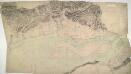
Newport 21
1 : 31680 This drawings depicts the winding course of the River Usk as it flows by the Roman town of Caerleon into the Severn Estuary and the Bristol Channel. Not far from the river mouth lies Newport. The Usk is not navigable except at this point, but the Monmouthshire and Brecon and Abergavenny canals, in part following the valley, carry a small trade up to Brecon. Cardiff, depicted at bottom left, was a town of only 6,000 inhabitants when this plan was produced. Budgen, Charles
Cardiff - OS One-Inch Map
1 : 63360 Topographic maps Ordnance Survey Ordnance Survey
Llantrisant
This plan covers part of the southern Welsh coast. Field boundaries and woodland are indicated. Shading and soft brushwork interlining ('hachuring') denote relief. The detailed recording of the undulations of the land is a defining feature of Ordnance Survey drawings, revealing the strategic and military impetus behind the scheme. Budgen, Thomas
Cardiff (Hills) - OS One-Inch Revised New Series
1 : 63360 Topographic maps Ordnance Survey Ordnance Survey
Cardiff (Outline) - OS One-Inch Revised New Series
1 : 63360 Topographic maps Ordnance Survey Ordnance Survey
Weston Super Mare (Hills) - OS One-Inch Revised New Series
1 : 63360 Topographic maps Ordnance Survey Ordnance Survey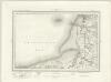
Weston Super Mare (Outline) - OS One-Inch Revised New Series
1 : 63360 Topographic maps Ordnance Survey Ordnance Survey
Bridgewater
This drawing covers the coastal area of Burnham on Sea. A careful study has been made of the coastline, noting sand banks and low watermarks and a lighthouse at Burnham. Faint pencil lines radiate from a mark near Westonzoyland. This shows the point from which angular measurements were taken to plot topographical features. The drawing is unfinished, roads and settlements in the lower half being left unnamed. Attention given to the accurate delineation of the road network sets these maps apart from earlier county plans and is a further reflection of the serious military emphasis of the Survey as a whole.
Minehead (Hills) - OS One-Inch Revised New Series
1 : 63360 Topographic maps Ordnance Survey Ordnance Survey
Minehead (Outline) - OS One-Inch Revised New Series
1 : 63360 Topographic maps Ordnance Survey Ordnance Survey
Pontypridd (Hills) - OS One-Inch Revised New Series
1 : 63360 Topographic maps Ordnance Survey Ordnance Survey
Pontypridd (Outline) - OS One-Inch Revised New Series
1 : 63360 Topographic maps Ordnance Survey Ordnance Survey
Minehead
Relief is depicted in this drawing by short lines ('hachures') rendered in blue-grey watercolour. The boundary between cartography and landscape painting is bridged somewhat in drawings such as this. Many of the drawing instructors for the Ordnance Survey were accomplished artists. Main communication routes are coloured yellow and marked at intervals of one mile.
Bedminster
This drawing covers the coastal area of the Bristol Channel. Pencil lines extending from a point adjacent to Honey Comb indicate the angular measurements taken to plot the coastline. Haven Military Battery is clearly marked at the mouth of the River Avon. Detail such as this is testimony to the military impetus behind the survey. A dotted red line running along the river Avon represents the old boundary between the counties of Somerset and Avon.
Axbridge
This drawing covers the Mendip Hills, from Wrington to Wells. Pencil rays extend from the left of the map towards Red Hill, on the right, and Mark and Tillham, on the bottom right. The draughtsman used these lines to measure relative distance and to plot locations by triangulation. Masberry Castle is shown in the bottom right, on top of a hill whose steepness is indicated by soft brushwork interlining ('hachuring'). The castle path joins the main turnpike road, whose length is annotated at intervals of one mile. Many field boundaries are marked in red, denoting stone walls rather than corrections in this case.
Taunton (Hills) - OS One-Inch Revised New Series
1 : 63360 Topographic maps Ordnance Survey Ordnance Survey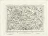
Taunton (Outline) - OS One-Inch Revised New Series
1 : 63360 Topographic maps Ordnance Survey Ordnance Survey
Lydiard St. Laurence
1 : 21120 This drawing covers part of Somerset. The narrow ridge of the Quantock Hills, depicted on the left by brushwork interlining, runs north west from Taunton Deane Vale for 19km to the Bristol Channel coast. At the top of the sheet, white rocks are indicated along the coastline of Bridgewater Bay. Woodland, heathland, formal parkland and arable land are distinguished by symbols.
Wells (Hills) - OS One-Inch Revised New Series
1 : 63360 Topographic maps Ordnance Survey Ordnance Survey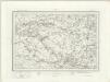
Wells (Outline) - OS One-Inch Revised New Series
1 : 63360 Topographic maps Ordnance Survey Ordnance Survey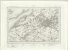
Bristol (Outline) - OS One-Inch Revised New Series
1 : 63360 Topographic maps Ordnance Survey Ordnance Survey
Bristol (Hills) - OS One-Inch Revised New Series
1 : 63360 Topographic maps Ordnance Survey Ordnance Survey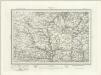
Dulverton (Outline) - OS One-Inch Revised New Series
1 : 63360 Topographic maps Ordnance Survey Ordnance Survey
Dulverton (Hills) - OS One-Inch Revised New Series
1 : 63360 Topographic maps Ordnance Survey Ordnance Survey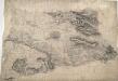
Glastonbury
Pencil orientation lines can be seen around the edges of this drawing. An arrow protruding from Wells indicates the link-point between this and another drawing. The flat lands of Burtle Heath and Kings Sedge Moor occupy half the drawing. Field boundaries and the manmade drainage system are recorded. Toll gates are marked 'TG' along the main turnpike road from Shepton Mallet to Somerton, which forms the edge of the drawing.
Glastonbury (Outline) - OS One-Inch Revised New Series
1 : 63360 Topographic maps Ordnance Survey Ordnance Survey