Maps of Landkreis Darmstadt-Dieburg

Section Darmstadt
Eckhardt, Christian Leonhard Philipp; Haas, Johann Heinrich; Meister, G.; Stoltz
[Brouillon der Gegend am Landgraben zwischen Griesheim und Wolfskehel bis zur Sandbach]
Hill, Johann Jakob
Le Flambeau de la Guerre Allumee au Rhin
Mollova mapová sbírka Delisle, Guillaume Schenk, Peter II
[Carte von Darmstadt und Umgebung]
Bechstatt, I. C.
Karte für die Uebungen der combinirten Kavallerie-Division bei Darmstadt 1877
1 : 50000 Welzbacher, C. Welzbacher
Das Ampt Dornberg
Lichtenberg, Johann Philipp
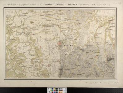
[Situations-Charte der Umgegend von Darmstadt]
Bechstatt, C.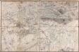
[Carte von Darmstadt und Umgebung]
Bechstatt, I. C.; Haas, Johann Heinrich
Carte von dem zwischen Chur Pfalz und Hessen Darmstadt Gemeinschaftlichen OberAmt Umstadt mit den Centorten
Beck, G. C. W.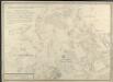
Carte von dem zwischen Chur Pfalz und Hessen Darmstadt gemeinschaftlichen Amt Umstatt mit den Centorten
Schmidt, Wilhelm Theophil
Manoeverfeld 1828
1 : 25000
Meßtischblatt 6118 : Rossdorf, 1889
1 : 250000 Rossdorf. - Bearb. 1889. - 1:25000. - [Darmstadt]: Grosshzgl. Katasteramt, 1889. - 1 Kt.
Meßtischblatt 6118 : Rossdorf, 1880
1 : 250000 Rossdorf. - Hrsg. ca. 1880. - 1:25000. - [Darmstadt]: Grosshzgl. Katasteramt, 1880. - 1 Kt.
Meßtischblatt 6117 : Darmstadt, 1886
1 : 250000 Darmstadt. - Bearb. 1886. - 1:25000. - [Darmstadt]: Grosshzgl. Katasteramt, 1886. - 1 Kt.
Meßtischblatt 6117 : Darmstadt, 1880
1 : 250000 Darmstadt. - Hrsg. ca. 1880. - 1:25000. - [Wiesbaden]: [Hess. Landesvermessungsamt], 1880. - 1 Kt.
[Carte zu den Herbst Manoeuvres]
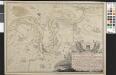
Plan De L'attaque á StockStad et de L'heurese Passage du Rhin de l'Armée Autrichien[n]e sous les Ordres de S. A. S. Le Prince Charle de Lorraine le 2me Juillet 1744
Karge, Johann Friedrich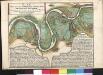
Plan Von Denen Strittigen RheinAuen bey Stockstatt und Leeheim
1 : 25000 Fehr, Peter
Manoeverfeld 18[28]
1 : 25000
Plan Von Denen Strittigen RheinAuen bey Stockstatt und Leeheim
1 : 25000 Fehr, Peter; Hill, Johann Jakob
Meßtischblatt 3440 : Mörfelden, 1935
1 : 250000 Mörfelden. - Bearb. 1889, Nachtr. bis 1932, Druckvm. 12.35 (u.li.). - 1:25000. - [Wiesbaden]: Hess. Landesvermessungsamt, 1935. - 1 Kt.
Meßtischblatt 48 : Mörfelden, 1914
1 : 250000 Mörfelden. - [Bearb. 1889]. - 1:25000. - [Wiesbaden]: Hess. Landesvermessungsamt, 1914. - 1 Kt.
Meßtischblatt [6018] = [49 Hess.] = [3441 Preuß.] : Messel, 1914
1 : 250000 Messel. - [Stand 1914?]. - 1:25000. - [Wiesbaden]: Hess. Landesvermessungsamt, [1914?]. - 1 Kt.
Meßtischblatt 6016 : Groß Gerau, 1941
1 : 250000 Groß Gerau. - Aufn. 1896/99, hrsg. 1901, bericht. 1936, Ausg. - 1:25000. - [Wiesbaden]: Hess. Landesvermessungsamt, 1941. - 1 Kt.
Meßtischblatt 47 : Gross-Gerau, 1899
1 : 250000 Gross-Gerau. - Bearb. 1896/99. - 1:25000. - [Wiesbaden]: Hess. Landesvermessungsamt, 1899. - 1 Kt.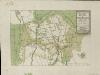
Grundriss über den Grossen Wild-Parck im Darmstler BurgerWald
Hill, Johann Jakob
Pharus-Plan Darmstadt
1 : 10000 Pharus-Verl.
Darmstadt
1 : 10000 Hess. Landesvermessungsamt
Darmstadt
1 : 10000 Lautz