Maps of Rödermark

Meßtischblatt [6018] = [49 Hess.] = [3441 Preuß.] : Messel, 1914
1 : 250000 Messel. - [Stand 1914?]. - 1:25000. - [Wiesbaden]: Hess. Landesvermessungsamt, [1914?]. - 1 Kt.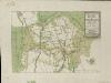
Grundriss über den Grossen Wild-Parck im Darmstler BurgerWald
Hill, Johann Jakob
Bey Granichstein
Karge, Johann Friedrich; Hill, Johann Jakob
Plan des Baillages D'Umstatt et D'Otzberg
Reuling, Louis
Territorium Francofurtense [Karte], in: Gerardi Mercatoris et I. Hondii Newer Atlas, oder, Grosses Weltbuch, Bd. 1, S. 218.
1 Karte aus Atlas Mercator, Gerhard und Hondius, Jodocus Jansson, Jan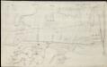
[Brouillon der Gegend am Landgraben zwischen Griesheim und Wolfskehel bis zur Sandbach]
Hill, Johann Jakob
Section Darmstadt
Eckhardt, Christian Leonhard Philipp; Haas, Johann Heinrich; Meister, G.; Stoltz
Territorium Francofurtense [Karte], in: Novus atlas absolutissimus, Bd. 2, S. 183.
1 Karte aus Atlas Janssonius Offizin
Novam Hanc TERRITORII FRANCOFVRTENSIS Tabulam...
[Amsterdam : Joan Blaeu]
Le Flambeau de la Guerre Allumee au Rhin
Mollova mapová sbírka Delisle, Guillaume Schenk, Peter II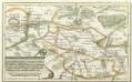
Geographische Vorstellung der Gegend zwischen Franckfurt und Aschaffenburg darinnen beyde Kriegen de Armeen wie sie gelagert, und alle s. wohl große als kleine Öhrfer Waldungen Flüß, Teich sambt alle Gräntz Scheidungen auf das accurateste dargestellet seynd
Mollova mapová sbírka
Territorium Sac. Rom. Imp. Lib. Civitatis Francofurti ad Moenum
1 : 65000 Mollova mapová sbírka Seutter, Matthäus Lotter, Tobias Conrad Seutter, Matthäus
Territorivm Francofvrtense
1 : 85000 Mollova mapová sbírka Valk, Gerhard Schenk, Peter II
Territorivm Francofvrtense
1 : 85000 Mollova mapová sbírka Janssonius, Johannes Janssonius, Johannes I
Novam hanc territorii Francofvrtensis tabulam / ... d.d.d. Johan. et Cornel. Blaeu
1 : 150000 Annotatie: Omringd door wapenschilden van magistraten uit Frankfurt aan de Main; Origineel is Blad 107 in atlas factice; Annotatie geografische gegevens: Met schaalstok Joan Blaeu 1597/98-1673; Cornelis Blaeu ca. 1610-1645 [Amsterdam : Joh. & Cornelius Blaeu]
[Carte von Darmstadt und Umgebung]
Bechstatt, I. C.
Carte von dem zwischen Chur Pfalz und Hessen Darmstadt Gemeinschaftlichen OberAmt Umstadt mit den Centorten
Beck, G. C. W.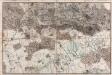
[Situations-Charte der Umgegend von Darmstadt]
Bechstatt, C.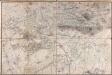
[Carte von Darmstadt und Umgebung]
Bechstatt, I. C.; Haas, Johann Heinrich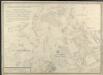
Carte von dem zwischen Chur Pfalz und Hessen Darmstadt gemeinschaftlichen Amt Umstatt mit den Centorten
Schmidt, Wilhelm Theophil
Novam Hanc Territorii Francofurtensis Tabulam [Karte], in: Novus Atlas, das ist, Weltbeschreibung, Bd. 1, S. 150.
1 Karte aus Atlas Blaeu, Joan Blaeu, Willem Janszoon
Novam Hanc Territorii Francofurtensis Tabulam [...] [Karte], in: Le théâtre du monde, ou, Nouvel atlas contenant les chartes et descriptions de tous les païs de la terre, Bd. 1, S. 181.
1 Karte aus Atlas Blaeu, Willem Janszoon und Blaeu, Joan Blaeu, Willem Janszoon
Situations Karte von Darmstadt und den umliegenden Gegenden zwischen Rhein, Mayn, Neckar &c.
Bechstatt, I. C.
Special Carte Des Rheinlaufes Von Speier Bis Bingen
Dewarat, Peter; Verhelst, Aegid Schwan und Götz
151. Darmstadt, uit: Topographische Uebersichtskarte des Deutschen Reiches / herausgegeben v. d. Kartogr. Abt. d. Königl. Preuß. Landesaufnahme
1 : 200000 titelvariant: Topogr. Übersichtskarte des Deutschen Reiches; Annotatie: Titel boven bladen ook: Topogr. Übersichtskarte des Deutschen Reiches; Annotatie geografische gegevens: Op elk blad twee maatstokken: 10 Kilometer = 5,5 cm; 1 geogr. Meile = 3,6 cm; Legenda onder op elk blad Königlich Preußische Landesaufnahme. Kartographische Abtheilung [S.l : Königlich Preußische Landesaufnahme, Kartographische Abtheilung]
Section Darmstadt, uit: Charte von dem Grossherzogtum Hessen und dem Herzogtum Nassau / trigonometrisch aufgenommen und hrsg. von C.L.P. Eckhardt
1 : 200000 titelvariant: Karte von Hessen und Nassau Eckhardt, C. L. P Darmstadt : Joh. Wilh. Heyer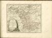


ERPACH | COMITATVS
[Amsterdam : Joan Blaeu]
![Meßtischblatt [6018] = [49 Hess.] = [3441 Preuß.] : Messel, 1914](https://images-2.georeferencer.com/images/iiif/397067118381/full/,300/0/native.jpg)

