Maps of Mühltal

Manoeverfeld 18[28]
1 : 25000
Situations Plan von der Gegend bey Eberstadt
Emil (Hessen, Prinz)
[Carte zu den Herbst Manoeuvres]

Meßtischblatt 6117 : Darmstadt, 1886
1 : 250000 Darmstadt. - Bearb. 1886. - 1:25000. - [Darmstadt]: Grosshzgl. Katasteramt, 1886. - 1 Kt.
Meßtischblatt 6117 : Darmstadt, 1880
1 : 250000 Darmstadt. - Hrsg. ca. 1880. - 1:25000. - [Wiesbaden]: [Hess. Landesvermessungsamt], 1880. - 1 Kt.
Manoeverfeld 18[28]
1 : 25000
Pharus-Plan Darmstadt
1 : 10000 Pharus-Verl.
Darmstadt
1 : 10000 Hess. Landesvermessungsamt
Darmstadt
1 : 10000 Lautz
[Carte von Darmstadt und Umgebung]
Bechstatt, I. C.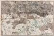
[Situations-Charte der Umgegend von Darmstadt]
Bechstatt, C.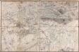
[Carte von Darmstadt und Umgebung]
Bechstatt, I. C.; Haas, Johann Heinrich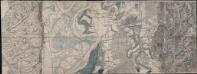
... Bogen der Haasischen Situations Carte
Haas, Johann Heinrich; Lyncker, Ludwig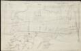
[Brouillon der Gegend am Landgraben zwischen Griesheim und Wolfskehel bis zur Sandbach]
Hill, Johann Jakob
Section Darmstadt
Eckhardt, Christian Leonhard Philipp; Haas, Johann Heinrich; Meister, G.; Stoltz
Karte für die Uebungen der combinirten Kavallerie-Division bei Darmstadt 1877
1 : 50000 Welzbacher, C. Welzbacher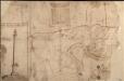
Das Ampt Dornberg
Lichtenberg, Johann Philipp
Topographisch-Militairische Carte
Bechstatt, I. C.
Accurate Hydrographische Carte von allen Fluessen, Baechen, Graeben, Ortschafften, Hoefen und Mühlen, sodann der Land-Graentze, auch Waldungen und Haupt-Strasen, laengs der Bergstrase von der Gegend Heppenhein bis über Eberstatt, ingleichem laengs dem Rhein von dem Einfluss der Weschnitz bis bey nahe Erfelden

Meßtischblatt 6118 : Rossdorf, 1889
1 : 250000 Rossdorf. - Bearb. 1889. - 1:25000. - [Darmstadt]: Grosshzgl. Katasteramt, 1889. - 1 Kt.
Meßtischblatt 6118 : Rossdorf, 1880
1 : 250000 Rossdorf. - Hrsg. ca. 1880. - 1:25000. - [Darmstadt]: Grosshzgl. Katasteramt, 1880. - 1 Kt.
Pharus-Plan Darmstadt
1 : 12500 Löwe, Cornelius Pharus-Verl.
Plan der Stadt Darmstadt
1 : 10000 Hessen, Landesvermessungsamt
Plan der Stadt Darmstadt
1 : 10000 Hess. Landesvermessungsamt
Plan von Darmstadt
1 : 10000 Welzbacher
Manoeverfeld 1862
1 : 10000
Le Flambeau de la Guerre Allumee au Rhin
Mollova mapová sbírka Delisle, Guillaume Schenk, Peter II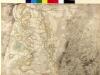
[Brouillon der Umgebung von Darmstadt]
Haas, Johann Heinrich; Lyncker, Ludwig; Meister, G.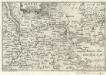
Maintz.
1 : 240000 Mollova mapová sbírka Person, Nikolaus Person, Nicolas
![Manoeverfeld 18[28]](https://images-2.georeferencer.com/images/iiif/171015659863/full/,300/0/native.jpg)

