Maps of Mörfelden-Walldorf

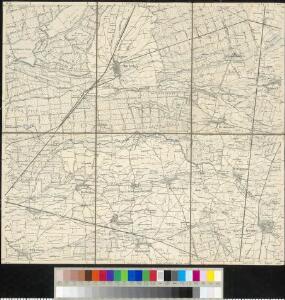
Meßtischblatt 3440 : Mörfelden, 1935
1 : 250000 Mörfelden. - Bearb. 1889, Nachtr. bis 1932, Druckvm. 12.35 (u.li.). - 1:25000. - [Wiesbaden]: Hess. Landesvermessungsamt, 1935. - 1 Kt.
Meßtischblatt 48 : Mörfelden, 1914
1 : 250000 Mörfelden. - [Bearb. 1889]. - 1:25000. - [Wiesbaden]: Hess. Landesvermessungsamt, 1914. - 1 Kt.
Manoeverfeld 1828
1 : 25000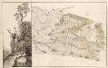
GeneralKarte des Gerauer und Mönchsbrucher Forsts nebst dem darinnen enthaltenen Wildparc
Heyer, Wilhelm
Karte für die Uebungen der combinirten Kavallerie-Division bei Darmstadt 1877
1 : 50000 Welzbacher, C. Welzbacher
[Brouillon der Gegend am Landgraben zwischen Griesheim und Wolfskehel bis zur Sandbach]
Hill, Johann Jakob
Territorium Francofurtense [Karte], in: Gerardi Mercatoris et I. Hondii Newer Atlas, oder, Grosses Weltbuch, Bd. 1, S. 218.
1 Karte aus Atlas Mercator, Gerhard und Hondius, Jodocus Jansson, Jan
Section Darmstadt
Eckhardt, Christian Leonhard Philipp; Haas, Johann Heinrich; Meister, G.; Stoltz
Territorium Francofurtense [Karte], in: Novus atlas absolutissimus, Bd. 2, S. 183.
1 Karte aus Atlas Janssonius Offizin
Novam Hanc TERRITORII FRANCOFVRTENSIS Tabulam...
[Amsterdam : Joan Blaeu]
Le Flambeau de la Guerre Allumee au Rhin
Mollova mapová sbírka Delisle, Guillaume Schenk, Peter II
Das Ampt Dornberg
Lichtenberg, Johann Philipp
Territorium Sac. Rom. Imp. Lib. Civitatis Francofurti ad Moenum
1 : 65000 Mollova mapová sbírka Seutter, Matthäus Lotter, Tobias Conrad Seutter, Matthäus
Territorivm Francofvrtense
1 : 85000 Mollova mapová sbírka Valk, Gerhard Schenk, Peter II
Territorivm Francofvrtense
1 : 85000 Mollova mapová sbírka Janssonius, Johannes Janssonius, Johannes I
[Carte von Darmstadt und Umgebung]
Bechstatt, I. C.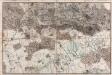
[Situations-Charte der Umgegend von Darmstadt]
Bechstatt, C.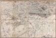
[Carte von Darmstadt und Umgebung]
Bechstatt, I. C.; Haas, Johann Heinrich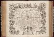
Novam hanc territorii Francofvrtensis tabulam / ... d.d.d. Johan. et Cornel. Blaeu
1 : 150000 Annotatie: Omringd door wapenschilden van magistraten uit Frankfurt aan de Main; Origineel is Blad 107 in atlas factice; Annotatie geografische gegevens: Met schaalstok Joan Blaeu 1597/98-1673; Cornelis Blaeu ca. 1610-1645 [Amsterdam : Joh. & Cornelius Blaeu]
Novam Hanc Territorii Francofurtensis Tabulam [Karte], in: Novus Atlas, das ist, Weltbeschreibung, Bd. 1, S. 150.
1 Karte aus Atlas Blaeu, Joan Blaeu, Willem Janszoon
Novam Hanc Territorii Francofurtensis Tabulam [...] [Karte], in: Le théâtre du monde, ou, Nouvel atlas contenant les chartes et descriptions de tous les païs de la terre, Bd. 1, S. 181.
1 Karte aus Atlas Blaeu, Willem Janszoon und Blaeu, Joan Blaeu, Willem Janszoon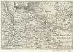
Maintz.
1 : 240000 Mollova mapová sbírka Person, Nikolaus Person, Nicolas
Situations Karte von Darmstadt und den umliegenden Gegenden zwischen Rhein, Mayn, Neckar &c.
Bechstatt, I. C.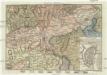
Gegend von Maynz
Mohuč (Německo) Engelmann, J. W. bey J.G. Oehler Buchdruck
Carte Topographique Du Cours Du Rhin De Philisbourg á Mayence
1 : 90000 le Rouge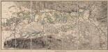
[Topographische Charte der Gegend zwischen Rhein, Neckar und Mayn]
Meister, G.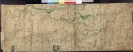
Le Cours Du Rhin Depuis Spire juisqu'à Mayence, les marches et Contremarches de l'Armée Francoise et les Camps y sont marqués Come aussi de l'Armée Alliée du coté du Main l'ann 1743 avec la Situation de l'Odewwald et du Berg Straass
Denis, Ferdinand
Special Carte Des Rheinlaufes Von Speier Bis Bingen
Dewarat, Peter; Verhelst, Aegid Schwan und Götz
Karte über das Überschwemmungsgebiet des Hochwassers im Winter 1882/83 längs des Main- und Rheinstromes in dem Großherzogthum Hessen
1 : 100000 Hessen-Darmstadt, Großherzogliche Landescultur-Inspection Bergsträsser