Maps of Meckenbeuren
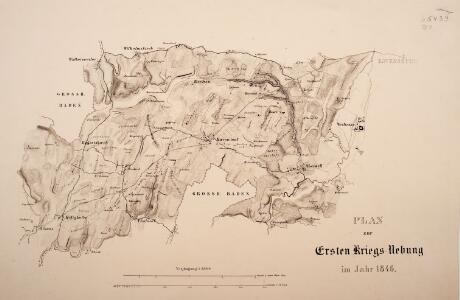
Plan zur ersten Kriegs-Uebung im Jahr 1846
1 : 25000
Minor Augia vulgo Weissenau
Eschach (Ravensburg, Německo) Gosner, Adalbert Ehmann, Andreas
Ravenspurgum S. Rom. Imperii civitas, arte optica exacte delineata
Ravensburg (Německo) Güssefeld, Franz L. Morin, F. H.
Meßtischblatt [8223] : Ravensburg, 1908
1 : 250000 Ravensburg. - 1:25000. - Stuttgart, 1908. - 1 Kt.
Meßtischblatt [8222] : Markdorf, Adelsreuthe, 1883
1 : 250000 Markdorf, Adelsreuthe. - [Ausg.] 1880 u. 1883. - 1:25000. - Leipzig: Giesecke & Devrient, 1883. - 2 Kt. auf 1 Bl.
Meßtischblatt 174 : Oberteuringen, 1907
1 : 250000 Oberteuringen. - 1:25000. - Stuttgart, 1877. - 1 Kt.
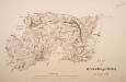
Plan zur zweiten Kriegs-Uebung im Jahr 1846
1 : 25000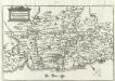
Comitatvs Tetnang Illustr. Comitum de Montfort, et confinia
1 : 120000 Mollova mapová sbírka Merian, Matthaeus Merian, Matthäus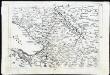
[Landvogdey in Schwaben]
Bodenehr, Johann Georg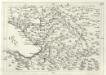
Geographica Provinciarum Sveviae Descriptio =
Mollova mapová sbírka Hurter, Johann Christoph Bodenehr, Johann Georg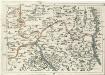
Geographica Provinciarum Sveviae Descriptio =
Mollova mapová sbírka Hurter, Johann Christoph Bodenehr, Gabriel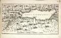
Lacus Acronianus
1 Karte : Kupferdruck ; 17 x 31 cm Seutter von Lötzen; Küffner; Som s.n.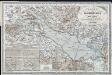
Karte vom Bodensee und seiner Umgebung : zum Hand und Reisegebrauche nach den neuesten und besten Materialien
Schedler, J. Schedler
187. Lindau, uit: Topographische Uebersichtskarte des Deutschen Reiches / herausgegeben v. d. Kartogr. Abt. d. Königl. Preuß. Landesaufnahme
1 : 200000 titelvariant: Topogr. Übersichtskarte des Deutschen Reiches; Annotatie: Titel boven bladen ook: Topogr. Übersichtskarte des Deutschen Reiches; Annotatie geografische gegevens: Op elk blad twee maatstokken: 10 Kilometer = 5,5 cm; 1 geogr. Meile = 3,6 cm; Legenda onder op elk blad Königlich Preußische Landesaufnahme. Kartographische Abtheilung [S.l : Königlich Preußische Landesaufnahme, Kartographische Abtheilung]
<<Der>> Boden-See
1 Vogelschaukarte Orell Füssli, Zürich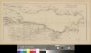
Situation der Linie Constanz - Romanshorn - Rorschach
1 : 100000 1 Karte [Kartogr.:] Topogr. Anst. v. Wurster, Randegger & Cie. in Winterthur Schweizerische Nordostbahn, [Erscheinungsort nicht ermittelbar]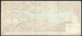
Bodenseekarte
1 : 50000 Schweiz Eidgenössisches Topographisches Bureau Eidg. Topogr. Büreau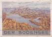
Der Bodensee
Bodamské jezero (oblast) M. Wittkop
Topographische Karte der Schweiz
1 : 100000 25 Karten vermessen und hrsg. auf Befehl der Eidgenössischen Behörden ; aufgenommen unter der Aufsicht des Generals G.H. Dufour Eidg. Topographisches Bureau, [Genève], [später: Bern]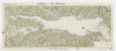
[Kaart], uit: Der Bodensee
1 : 100000 Annotatie: Verso: toeristische informatie Stuttgart : Von Paasche & Luz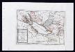
Das Bisthum Constanz, die Grafschaft Montfort oder die Herrschaften Tetnang und Argen, die Grafschaften Hohenembs, Vadutz und Schellenberg mit den freyen Reichsstädten Ueberlingen, Wangen, Lindau und Buchhorn : Nro. 196
Reilly, Franz Johann Joseph von
Lacus Bodamicus vel Acronius cum regionibus circumjacentibus recens delineatus
1 : 170000 Mollova mapová sbírka Seutter, Matthäus Seutter, Matthäus
Partie du ct. Sentis et Autriche anterieure
1 : 108000 Weiss, Johann Heinrich ; Guérin, Christophe ; Meyer, Johann Rudolf J. R. Meyer
Partie Du Ct. Sentis Et Autriche Anterieure
1 : 120000 Weiss, Johann Heinrich Mayer Johann Rudolf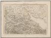
Topographische Karte der Schweiz (Dufour-Karte): Den Kanton Zürich betreffende Blätter: Blatt IV: Frauenfeld, St. Gallen
1 : 100000 Leitung: Dufour, Guillaume-Henri (1787-1875), General, Politiker, Ingenieur und Kartograf, von Genf; Eidgenössisches Topographisches Bureau, in Genf Stich: Bachofen, Johann Heinrich, andere Schreibweise: Jean-Henri, (1821-1889), Zeichner, Maler, Architekt und Topograf, von Uster; Bressanini, Rinaldo (1803-1864), Kupferstecher und Kartograf, von Italien; Müllhaupt, Heinrich (1820-1894), Kupferstecher und Kartograf, von Hofstetten; Stempelmann, J. (1835-1887) Druck: Koegel, Henri (1816-1867)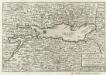
Bodensee alias Lacus Bodamicus Acronius, Brigantinus
1 : 270000 Mollova mapová sbírka Person, Nikolaus Person, Nicolas
Frauenfeld, St. Gallen
1 : 100000 1 Karte von F. Schalch, A. Gutzwiller, J. Schill [Wurster & Randegger], [Winterthur]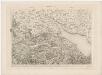
Topographische Karte der Schweiz (Dufour-Karte): Den Kanton Zürich betreffende Blätter: Blatt IV: Frauenfeld, St. Gallen
1 : 100000 Leitung: Dufour, Guillaume-Henri (1787-1875), General, Politiker, Ingenieur und Kartograf, von Genf; Eidgenössisches Topographisches Bureau, in Genf Stich: Bachofen, Johann Heinrich, andere Schreibweise: Jean-Henri, (1821-1889), Zeichner, Maler, Architekt und Topograf, von Uster; Bressanini, Rinaldo (1803-1864), Kupferstecher und Kartograf, von Italien; Müllhaupt, Heinrich (1820-1894), Kupferstecher und Kartograf, von Hofstetten
Lacus Bodamicus vel Acronius cum regionibus circumiacentibus
Seutter, Matthäus Probst