Maps of Bodenseekreis
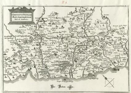
Comitatvs Tetnang Illustr. Comitum de Montfort, et confinia
1 : 120000 Mollova mapová sbírka Merian, Matthaeus Merian, Matthäus
Boden-See
1 : 75000 Kartograph., früher Militärgeograph. Inst.
Veriungter Abriss des Heyl. Reichs Statt Lindaw, vnd derselben theils Allieglicher, theils allein Nidergerichtlicher Oberkeit aus der
Mollova mapová sbírka Rauch, Johann Andreas
Veriungter Abriss des Heyl. Reichs Statt Lindaw, vnd derselben theils Allieglicher, theils allein Nidergerichtlicher Oberkeit aus der
Mollova mapová sbírka Rauch, Johann Andreas
Meßtischblatt [8324] : Neukirch (Württ.), Achberg (Preuß.), 1911
1 : 250000 Neukirch (Württ.), Achberg (Preuß.). - Hrsg. 1895, 2. Ausg., 1911. - 1:25000. - Stuttgart, 1911. - 1 Kt.
Meßtischblatt [8323] : Tettnang, 1908
1 : 250000 Tettnang. - 1:25000. - Stuttgart, 1908. - 1 Kt.
Meßtischblatt [8322] : Friedrichshafen, 1905
1 : 250000 Friedrichshafen. - 2. Ausg. - 1:25000. - Stuttgart, 1905. - 1 Kt.
Meßtischblatt [8322] : Immenstaad, 1880
1 : 250000 Immenstaad. - [Ausg.] 1879 u. 1880. - 1:25000. - Leipzig: Giesecke & Devrient, 1880. - 1 Kt.
Meßtischblatt [8224] : Waldburg, 1908
1 : 250000 Waldburg. - 1:25000. - Stuttgart, 1908. - 1 Kt.
Meßtischblatt [8223] : Ravensburg, 1908
1 : 250000 Ravensburg. - 1:25000. - Stuttgart, 1908. - 1 Kt.
Meßtischblatt [8222] : Markdorf, Adelsreuthe, 1883
1 : 250000 Markdorf, Adelsreuthe. - [Ausg.] 1880 u. 1883. - 1:25000. - Leipzig: Giesecke & Devrient, 1883. - 2 Kt. auf 1 Bl.
Meßtischblatt 174 : Oberteuringen, 1907
1 : 250000 Oberteuringen. - 1:25000. - Stuttgart, 1877. - 1 Kt.
CIVITATIS IMP. | LINDAVIENSIS | TERRITORIVM.
ita Delineabat | Iohannes Andreas Rauhen. [Amsterdam : Joan Blaeu]
Plan zur ersten Kriegs-Uebung im Jahr 1846
1 : 25000
TERRITORII | LINDAVIENSIS | PARS SEPTENTRIONALIS
[Amsterdam : Joan Blaeu]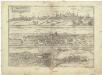
Nvrnberga florentißimum Germaniae emporium, rempub. optima politia illustre, et in burggrauior s. impeii ordine, alter. dignitatis locu habet
Lindau (Bavorsko, Německo) Braun, Georg Hogenberg, Franz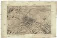
Ravenspurgum S. Rom. Imperii civitas, arte optica exacte delineata
Ravensburg (Německo) Güssefeld, Franz L. Morin, F. H.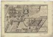
Minor Augia vulgo Weissenau
Eschach (Ravensburg, Německo) Gosner, Adalbert Ehmann, Andreas
Plan zur zweiten Kriegs-Uebung im Jahr 1846
1 : 25000
Meßtischblatt [8423] : Langenargen, 1893
1 : 250000 Langenargen. - 1:25000. - Stuttgart, 1893. - 1 Kt.
<<Der>> Boden-See
1 Vogelschaukarte Orell Füssli, Zürich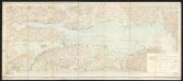
Bodenseekarte
1 : 50000 Schweiz Eidgenössisches Topographisches Bureau Eidg. Topogr. Büreau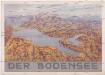
Der Bodensee
Bodamské jezero (oblast) M. Wittkop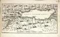
Lacus Acronianus
1 Karte : Kupferdruck ; 17 x 31 cm Seutter von Lötzen; Küffner; Som s.n.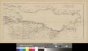
Situation der Linie Constanz - Romanshorn - Rorschach
1 : 100000 1 Karte [Kartogr.:] Topogr. Anst. v. Wurster, Randegger & Cie. in Winterthur Schweizerische Nordostbahn, [Erscheinungsort nicht ermittelbar]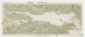
[Kaart], uit: Der Bodensee
1 : 100000 Annotatie: Verso: toeristische informatie Stuttgart : Von Paasche & Luz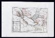
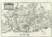
Das Bisthum Constanz, die Grafschaft Montfort oder die Herrschaften Tetnang und Argen, die Grafschaften Hohenembs, Vadutz und Schellenberg mit den freyen Reichsstädten Ueberlingen, Wangen, Lindau und Buchhorn : Nro. 196
Reilly, Franz Johann Joseph von
Bodensee.
from Spezialkarte der osterreichisch-ungarischen Monarchie.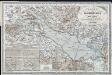
Karte vom Bodensee und seiner Umgebung : zum Hand und Reisegebrauche nach den neuesten und besten Materialien
Schedler, J. Schedler