Maps of Landkreis Lindau
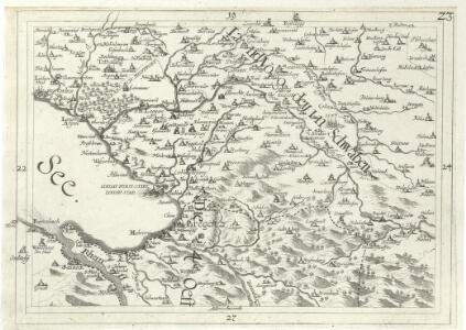
Geographica Provinciarum Sveviae Descriptio =
Mollova mapová sbírka Hurter, Johann Christoph Bodenehr, Johann Georg
[Landvogdey in Schwaben]
Bodenehr, Johann Georg
Blatt V: Rheineck, Verzeichniss von Ortsbenennungen in verschiedenen Sprachen, uit: Topographische Karte der Schweiz / vermessen und hrsg. ... unter Aufsicht des Generals G.H. Dufour
1 : 100000 Annotatie: Met plaatsnamenregister (bl. V), bladwijzer (bl. XXI) en hoogteregister (bl. XXV); Voor aanwezige bladen zie overzichtsblad Dufour, G. H. [Bern : Eidg. Topogr. Bureau]
Topographische Karte der Schweiz (Dufour-Karte): Den Kanton Zürich betreffende Blätter: Blatt V: Rheineck; Verzeichnis von Ortsbenennungen in verschiedenen Sprachen, Zeichen und Abkürzungen
1 : 100000 Leitung: Dufour, Guillaume-Henri (1787-1875), General, Politiker, Ingenieur und Kartograf, von Genf; Eidgenössisches Topographisches Bureau, in Genf Stich: Bressanini, Rinaldo (1803-1864), Kupferstecher und Kartograf, von Italien; Müllhaupt, Heinrich (1820-1894), Kupferstecher und Kartograf, von Hofstetten; Werdmüller, Johann Conrad (1826-1849), Kupferstecher, in Genf
Bodensee.
from Spezialkarte der osterreichisch-ungarischen Monarchie.
Isny und Immenstadt.
from Spezialkarte der osterreichisch-ungarischen Monarchie.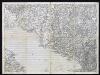
Boden-See
1 : 75000 Kartograph., früher Militärgeograph. Inst.
[Bregenz]
1 : 86400 Amman, Ignaz Ambros Cotta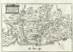
Comitatvs Tetnang Illustr. Comitum de Montfort, et confinia
1 : 120000 Mollova mapová sbírka Merian, Matthaeus Merian, Matthäus
Veriungter Abriss des Heyl. Reichs Statt Lindaw, vnd derselben theils Allieglicher, theils allein Nidergerichtlicher Oberkeit aus der
Mollova mapová sbírka Rauch, Johann Andreas
Veriungter Abriss des Heyl. Reichs Statt Lindaw, vnd derselben theils Allieglicher, theils allein Nidergerichtlicher Oberkeit aus der
Mollova mapová sbírka Rauch, Johann Andreas
Topographische Karte des Cantons St. Gallen mit Einschluss des Cantons Appenzell
1 : 25000 16 Karten aufgenommen von J. Eschmann ... [et al.] ; gestochen von P. Steiner ; Gebirg von J. Randegger ; Gebirgszeichnung u. Leitung des Stiches durch J.M. Ziegler Topographische Anstalt v. Joh. Wurster & Comp., Winterthur
Topographische Karte des Kantons St. Gallen mit Einschluss des Kantons Appenzell (Eschmann-Karte): Blatt Rheineck
1 : 25000 Mit statistischer Tabelle. Aufnahme: Hennet, Théodore Hippolyte (1819-1879), Ingenieur; Merz, Johann Ludwig, andere Schreibweise: Mertz, (1772-1851), Kaufmann und Oberstleutnant, von Herisau AR Stich: Steiner, P.; Leuzinger, Rudolf (1826-1896), Kartograf und Lithograf, von Netstal GL und Mollis GL Gebirgszeichnung und Leitung des Stichs: Ziegler, Jakob Melchior (1801-1883), Kartograf Stich und Druck: Joh. Wurster und Comp., in Winterthur
Topographische Karte des Cantons St. Gallen mit Einschluss des Cantons Appenzell
1 : 25000 Blatt 4 Eschmann, Johannes ; Steiner, P. ; Randegger, Johannes ; Ziegler, Jakob Melchior Topographische Anstalt v. Joh. Wurster & Comp.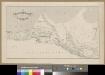
<<Die>> Rheinmündung in den Bodensee
1 : 25000 1 Karte Topogr. Anstalt v. J. Wurster u. Comp., [Winterthur]
Rhein-Correction
1 : 25000 Blatt Rheineck Topographische Anstalt von Joh. Wurster u. Comp. (Winterthur) J. Wurster u. Comp.
Rhein-Correction
1 : 25000 4 Karten J. Wurster u. Comp., Winterthur
Sargans SG bis Rheineck SG: Rheinkorrektionen; Grundrisse: Blatt 4: Rheineck
1 : 25000 Mit Querprofil sowie Kostenvoranschlag nach Gemeinden und Baugegenständen. Joh. Wurster und Comp., in Winterthur
Topographische Karte Bayern 1:50 000. 95, Rindalphorn (West)
1 : 50000 [Munchen] : K.B. Generalstabes
Zu Bildner des Heeres Beilage 23
1 : 36000 Bregenz-oblast (Rakousko) K.k. Schulbücher-Verschleiss-Administration
Meßtischblatt [8423] : Langenargen, 1893
1 : 250000 Langenargen. - 1:25000. - Stuttgart, 1893. - 1 Kt.
Meßtischblatt [8326] : Isny, 1920
1 : 250000 Isny. - 1:25000. - Stuttgart, 1920. - 1 Kt.
Meßtischblatt [8325] : Wangen, 1920
1 : 250000 Wangen. - 1:25000. - Stuttgart, 1920. - 1 Kt.
Meßtischblatt [8324] : Neukirch (Württ.), Achberg (Preuß.), 1911
1 : 250000 Neukirch (Württ.), Achberg (Preuß.). - Hrsg. 1895, 2. Ausg., 1911. - 1:25000. - Stuttgart, 1911. - 1 Kt.
Meßtischblatt [8323] : Tettnang, 1908
1 : 250000 Tettnang. - 1:25000. - Stuttgart, 1908. - 1 Kt.
CIVITATIS IMP. | LINDAVIENSIS | TERRITORIVM.
ita Delineabat | Iohannes Andreas Rauhen. [Amsterdam : Joan Blaeu]
Meßtischblatt [8223] : Ravensburg, 1908
1 : 250000 Ravensburg. - 1:25000. - Stuttgart, 1908. - 1 Kt.
Meßtischblatt [8224] : Waldburg, 1908
1 : 250000 Waldburg. - 1:25000. - Stuttgart, 1908. - 1 Kt.
Meßtischblatt [8225] : Kisslegg, 1907
1 : 250000 Kisslegg. - 1:25000. - Stuttgart, 1907. - 1 Kt.