Maps of Předhradí

Indikační skica mapy stabilního katastru pro obec Rychmburk a osady Lažany, Lešany a Dolívka
1 : 2880
Katastrální mapa pro obec Rychmburk
1 : 2880
Mapa dominikálních pozemků v Hlubočicích, Dolech, Rabouni, Hněvěticích, Borku, Chlumu, Lhotě u Skutče a Štěpánově
1 : 3448
Hniewietitz (Hněwětic) - c1907-1-001 - Kaiserpflichtexemplar der Landkarten des stabilen Katasters
1 : 2880
Hniewietitz (Hněwětic) - c1907-1-003 - Kaiserpflichtexemplar der Landkarten des stabilen Katasters
1 : 2880
Hniewietitz (Hněwětic) - c1907-1-002 - Kaiserpflichtexemplar der Landkarten des stabilen Katasters
1 : 2880
Lhotta - c3946-1-002 - Kaiserpflichtexemplar der Landkarten des stabilen Katasters
1 : 2880
Lhotta - c3946-1-001 - Kaiserpflichtexemplar der Landkarten des stabilen Katasters
1 : 2880
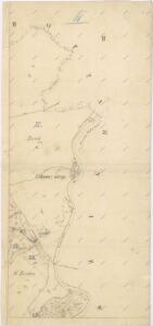
Mapa rychmburské stráně
1 : 3000
Mapa osad Dolany, Chlum, Hlubočice, Rvasice, Brdo, Zhoř a Hluboká
1 : 4164
Porostní mapa polesí Ochoz
1 : 10000
Porostní mapa polesí Ochoz
1 : 10000
Richenburg (Richunburk) - c6167-2-004 - Kaiserpflichtexemplar der Landkarten des stabilen Katasters
1 : 2880
Richenburg (Richunburk) - c6167-2-007 - Kaiserpflichtexemplar der Landkarten des stabilen Katasters
1 : 2880
Richenburg (Richunburk) - c6167-2-002 - Kaiserpflichtexemplar der Landkarten des stabilen Katasters
1 : 2880
Richenburg (Richunburk) - c6167-2-006 - Kaiserpflichtexemplar der Landkarten des stabilen Katasters
1 : 2880
Richenburg (Richunburk) - c6167-2-005 - Kaiserpflichtexemplar der Landkarten des stabilen Katasters
1 : 2880
Richenburg (Richunburk) - c6167-2-003 - Kaiserpflichtexemplar der Landkarten des stabilen Katasters
1 : 2880
Richenburg (Richunburk) - c6167-2-001 - Kaiserpflichtexemplar der Landkarten des stabilen Katasters
1 : 2880
Doll (Dol) - c1421-1-001 - Kaiserpflichtexemplar der Landkarten des stabilen Katasters
1 : 2880
Doll (Dol) - c1421-1-005 - Kaiserpflichtexemplar der Landkarten des stabilen Katasters
1 : 2880
Doll (Dol) - c1421-1-002 - Kaiserpflichtexemplar der Landkarten des stabilen Katasters
1 : 2880
Doll (Dol) - c1421-1-006 - Kaiserpflichtexemplar der Landkarten des stabilen Katasters
1 : 2880
Doll (Dol) - c1421-1-004 - Kaiserpflichtexemplar der Landkarten des stabilen Katasters
1 : 2880
Doll (Dol) - c1421-1-003 - Kaiserpflichtexemplar der Landkarten des stabilen Katasters
1 : 2880
Mapa vrchnostenského dvora Rychmburk a k němu náležejícím pozemkům
1 : 3512
Mapa vrchnostenského dvora Rychmburk a k němu náležejícím pozemkům
1 : 3448
Mapa části panství Rychmburk Blatt I.
1 : 2880
Indikační skica mapy stabilního katastru pro obec Rychmburk a osady Lažany, Lešany a Dolívka
1 : 2880