Maps of Předhradí
Mapa vrchnostenského dvora Rychmburk a k němu náležejícím pozemkům
1 : 3448
Mapa vrchnostenského dvora Rychmburk a k němu náležejícím pozemkům
1 : 3512
Porostní mapa polesí Ochoz
1 : 10000
Mapa rychmburské stráně
1 : 3000
Mirzetin (Miřetin) - c4714-1-002 - Kaiserpflichtexemplar der Landkarten des stabilen Katasters
1 : 2880
Mirzetin (Miřetin) - c4714-1-001 - Kaiserpflichtexemplar der Landkarten des stabilen Katasters
1 : 2880
Indikační skica mapy stabilního katastru pro obec Rychmburk a osady Lažany, Lešany a Dolívka
1 : 2880
Mapa části panství Rychmburk Blatt I.
1 : 2880
Katastrální mapa pro obec Rychmburk
1 : 2880
Indikační skica mapy stabilního katastru pro obec Perálec a osadu Kutřín
1 : 2880
Katastrální mapa pro obec Rychmburk
1 : 2880
Katastrální mapa pro obec Rychmburk
1 : 2880
Indikační skica mapy stabilního katastru pro obec Česká Rybná
1 : 2880
Richenburg (Richunburk) - c6167-2-004 - Kaiserpflichtexemplar der Landkarten des stabilen Katasters
1 : 2880
Richenburg (Richunburk) - c6167-2-007 - Kaiserpflichtexemplar der Landkarten des stabilen Katasters
1 : 2880
Richenburg (Richunburk) - c6167-2-002 - Kaiserpflichtexemplar der Landkarten des stabilen Katasters
1 : 2880
Richenburg (Richunburk) - c6167-2-006 - Kaiserpflichtexemplar der Landkarten des stabilen Katasters
1 : 2880
Richenburg (Richunburk) - c6167-2-005 - Kaiserpflichtexemplar der Landkarten des stabilen Katasters
1 : 2880
Richenburg (Richunburk) - c6167-2-003 - Kaiserpflichtexemplar der Landkarten des stabilen Katasters
1 : 2880
Richenburg (Richunburk) - c6167-2-001 - Kaiserpflichtexemplar der Landkarten des stabilen Katasters
1 : 2880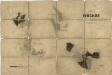
Porostní mapa polesí Ochoz
1 : 10000
Mapa vrchnostenského dvora Daletice a vsi Lešany
1 : 3853
Mapa vsi Otradov a Miřetín
1 : 4055
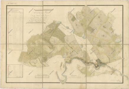
Katastrální mapa obce Rychmburk (Předhradí)
1 : 2880
Hniewietitz (Hněwětic) - c1907-1-001 - Kaiserpflichtexemplar der Landkarten des stabilen Katasters
1 : 2880
Hniewietitz (Hněwětic) - c1907-1-003 - Kaiserpflichtexemplar der Landkarten des stabilen Katasters
1 : 2880
Hniewietitz (Hněwětic) - c1907-1-002 - Kaiserpflichtexemplar der Landkarten des stabilen Katasters
1 : 2880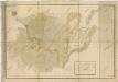
Mapa pozemků vrchnostenského dvora Daletice
1 : 3793
Indikační skica mapy stabilního katastru pro obec Otradov I
1 : 2880