Maps of Tržek
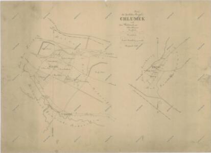
Mapa části polesí Chlumek
1 : 5760
Nedoschin (Nedossin) - c4997-1-002 - Kaiserpflichtexemplar der Landkarten des stabilen Katasters
1 : 2880
Nedoschin (Nedossin) - c4997-1-001 - Kaiserpflichtexemplar der Landkarten des stabilen Katasters
1 : 2880
Nedoschin (Nedossin) - c4997-1-003 - Kaiserpflichtexemplar der Landkarten des stabilen Katasters
1 : 2880
Porostní mapa revíru Chlumek (lesy Park a Řídký)
1 : 5760
Katastrální mapa obce Nedošín 2; 4
1 : 2880
Katastrální mapa obce Nedošín 5
1 : 2880
Katastrální mapa obce Nedošín 3
1 : 2880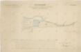
Mapa části panského pozemku u vrchnostenského dvora Pernštejn v Nedošíně
1 : 2918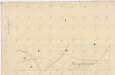
Indikační skica mapy stabilního katastru pro obec Lány (předměstí města Litomyšle) I
1 : 2880
Indikační skica mapy stabilního katastru pro obec Lány (předměstí města Litomyšle)
1 : 2880
Indikační skica mapy stabilního katastru pro obec Lažany I
1 : 2880
Indikační skica mapy stabilního katastru pro obec Lány (předměstí města Litomyšle)
1 : 2880
Vorstadt Lany (Lany) - c3800-1-001 - Kaiserpflichtexemplar der Landkarten des stabilen Katasters
1 : 2880
Vorstadt Lany (Lany) - c3800-1-002 - Kaiserpflichtexemplar der Landkarten des stabilen Katasters
1 : 2880
Katastrální mapa obce Malé Sedliště (Sedlíšťka) a osady Nová Sídla 4
1 : 2880
Trschek - c8010-1-001 - Kaiserpflichtexemplar der Landkarten des stabilen Katasters
1 : 2880
Trschek - c8010-1-002 - Kaiserpflichtexemplar der Landkarten des stabilen Katasters
1 : 2880
Indikační skica mapy stabilního katastru pro obec Kornice II; III
1 : 2880
Leitomischl (Litomissle) - c4172-1-004 - Kaiserpflichtexemplar der Landkarten des stabilen Katasters
1 : 2880
Leitomischl (Litomissle) - c4172-1-001 - Kaiserpflichtexemplar der Landkarten des stabilen Katasters
1 : 2880
Leitomischl (Litomissle) - c4172-1-006 - Kaiserpflichtexemplar der Landkarten des stabilen Katasters
1 : 2880
Leitomischl (Litomissle) - c4172-1-005 - Kaiserpflichtexemplar der Landkarten des stabilen Katasters
1 : 2880
Leitomischl (Litomissle) - c4172-1-003 - Kaiserpflichtexemplar der Landkarten des stabilen Katasters
1 : 2880
Leitomischl (Litomissle) - c4172-1-002 - Kaiserpflichtexemplar der Landkarten des stabilen Katasters
1 : 2880
Indikační skica mapy stabilního katastru pro obec Újezdec I
1 : 2880
Mapa pozemků vsí Nová Sídla, Řídký a Sedlíšťka
1 : 3647
Gross Sedlischt (Welko Sedlissti) - c6801-1-002 - Kaiserpflichtexemplar der Landkarten des stabilen Katasters
1 : 2880
Gross Sedlischt (Welko Sedlissti) - c6801-1-001 - Kaiserpflichtexemplar der Landkarten des stabilen Katasters
1 : 2880
Kornitz (Kornjce) - c3338-1-002 - Kaiserpflichtexemplar der Landkarten des stabilen Katasters
1 : 2880