Maps of Tržek

Mapa pozemků vsí Nová Sídla, Řídký a Sedlíšťka
1 : 3647
Trschek - c8010-1-001 - Kaiserpflichtexemplar der Landkarten des stabilen Katasters
1 : 2880
Trschek - c8010-1-002 - Kaiserpflichtexemplar der Landkarten des stabilen Katasters
1 : 2880
Mapa intravilánu vsi Nová Sídla
1 : 2880
Katastrální mapa obce Malé Sedliště (Sedlíšťka) a osady Nová Sídla 4
1 : 2880
Katastrální mapa obce Bohuňovice a osady Řídký
1 : 2880
Indikační skica mapy stabilního katastru pro obec Bohuňovice a osadu Řídký
1 : 2880
Mapa bažantnice u vsi Nová Sídla
1 : 3000
Katastrální mapa obce Malé Sedliště (Sedlíšťka) a osady Nová Sídla 1; 4
1 : 2880
Indikační skica mapy stabilního katastru pro obec Cerekvice nad Loučnou IV
1 : 2880
Indikační skica mapy stabilního katastru pro obec Lažany I
1 : 2880
Indikační skica mapy stabilního katastru pro obec Cerekvice nad Loučnou ad I; V
1 : 2880
Indikační skica mapy stabilního katastru pro obec Újezdec I
1 : 2880
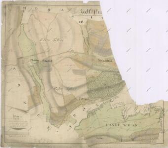
Moraschitz (Morassice) - c4831-1-002 - Kaiserpflichtexemplar der Landkarten des stabilen Katasters
1 : 2880
Moraschitz (Morassice) - c4831-1-005 - Kaiserpflichtexemplar der Landkarten des stabilen Katasters
1 : 2880
Moraschitz (Morassice) - c4831-1-003 - Kaiserpflichtexemplar der Landkarten des stabilen Katasters
1 : 2880
Moraschitz (Morassice) - c4831-1-004 - Kaiserpflichtexemplar der Landkarten des stabilen Katasters
1 : 2880
Moraschitz (Morassice) - c4831-1-001 - Kaiserpflichtexemplar der Landkarten des stabilen Katasters
1 : 2880
Bohniowitz (Bohniowyc) - c0321-1-001 - Kaiserpflichtexemplar der Landkarten des stabilen Katasters
1 : 2880
Bohniowitz (Bohniowyc) - c0321-1-004 - Kaiserpflichtexemplar der Landkarten des stabilen Katasters
1 : 2880
Bohniowitz (Bohniowyc) - c0321-1-003 - Kaiserpflichtexemplar der Landkarten des stabilen Katasters
1 : 2880
Bohniowitz (Bohniowyc) - c0321-1-002 - Kaiserpflichtexemplar der Landkarten des stabilen Katasters
1 : 2880
Katastrální mapa obce Nedošín 2; 4
1 : 2880
Indikační skica mapy stabilního katastru pro obec Morašice a osady Nová Sídla a Malé Sedliště (Sedlíšťka) 6
1 : 2880
Katastrální mapa obce Morašice VI
1 : 2880
Indikační skica mapy stabilního katastru pro obec Lažany II; III
1 : 2880
Porostní mapa revíru Chlumek (lesy Park a Řídký)
1 : 5760
Mapa politického okresu Litomyšlského

Czerekwitz (Czerekwicz) - c0742-1-002 - Kaiserpflichtexemplar der Landkarten des stabilen Katasters
1 : 2880
Czerekwitz (Czerekwicz) - c0742-1-001 - Kaiserpflichtexemplar der Landkarten des stabilen Katasters
1 : 2880
Czerekwitz (Czerekwicz) - c0742-1-003 - Kaiserpflichtexemplar der Landkarten des stabilen Katasters
1 : 2880