Maps of Bohuňovice

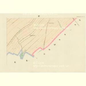
Bohniowitz (Bohniowyc) - c0321-1-001 - Kaiserpflichtexemplar der Landkarten des stabilen Katasters
1 : 2880
Bohniowitz (Bohniowyc) - c0321-1-004 - Kaiserpflichtexemplar der Landkarten des stabilen Katasters
1 : 2880
Bohniowitz (Bohniowyc) - c0321-1-003 - Kaiserpflichtexemplar der Landkarten des stabilen Katasters
1 : 2880
Bohniowitz (Bohniowyc) - c0321-1-002 - Kaiserpflichtexemplar der Landkarten des stabilen Katasters
1 : 2880
Indikační skica mapy stabilního katastru pro obec Bohuňovice a osadu Řídký
1 : 2880
Katastrální mapa obce Bohuňovice a osady Řídký
1 : 2880
Indikační skica mapy stabilního katastru pro obec Bohuňovice a osadu Řídký
1 : 2880
Indikační skica mapy stabilního katastru pro obec Bohuňovice a osadu Řídký
1 : 2880
Katastrální mapa obce Bohuňovice a osady Řídký
1 : 2880
Indikační skica mapy stabilního katastru pro obec Cerekvice nad Loučnou II
1 : 2880
Indikační skica mapy stabilního katastru pro obec Cerekvice nad Loučnou IV
1 : 2880
Gross Sedlischt (Welko Sedlissti) - c6801-1-002 - Kaiserpflichtexemplar der Landkarten des stabilen Katasters
1 : 2880
Gross Sedlischt (Welko Sedlissti) - c6801-1-001 - Kaiserpflichtexemplar der Landkarten des stabilen Katasters
1 : 2880
Horek - c2005-1-001 - Kaiserpflichtexemplar der Landkarten des stabilen Katasters
1 : 2880
Horek - c2005-1-002 - Kaiserpflichtexemplar der Landkarten des stabilen Katasters
1 : 2880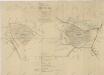
Silniční mapa polesí Chlumek
1 : 5760
Trschek - c8010-1-001 - Kaiserpflichtexemplar der Landkarten des stabilen Katasters
1 : 2880
Trschek - c8010-1-002 - Kaiserpflichtexemplar der Landkarten des stabilen Katasters
1 : 2880
Katastrální mapa obce Horky 2
1 : 2880
Mapa politického okresu Litomyšlského
Indikační skica mapy stabilního katastru pro obec Újezdec I
1 : 2880
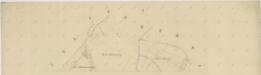
Mapa pozemků vsí Nová Sídla, Řídký a Sedlíšťka
1 : 3647
Czerekwitz (Czerekwicz) - c0742-1-002 - Kaiserpflichtexemplar der Landkarten des stabilen Katasters
1 : 2880
Czerekwitz (Czerekwicz) - c0742-1-001 - Kaiserpflichtexemplar der Landkarten des stabilen Katasters
1 : 2880
Czerekwitz (Czerekwicz) - c0742-1-003 - Kaiserpflichtexemplar der Landkarten des stabilen Katasters
1 : 2880
Czerekwitz (Czerekwicz) - c0742-1-004 - Kaiserpflichtexemplar der Landkarten des stabilen Katasters
1 : 2880
Hermanitz (Hermanjce) - c0967-1-003 - Kaiserpflichtexemplar der Landkarten des stabilen Katasters
1 : 2880
Hermanitz (Hermanjce) - c0967-1-004 - Kaiserpflichtexemplar der Landkarten des stabilen Katasters
1 : 2880
Hermanitz (Hermanjce) - c0967-1-002 - Kaiserpflichtexemplar der Landkarten des stabilen Katasters
1 : 2880