Maps of Domanín

Hospodářská mapa dvora Vrchy 1

Plán pozemků dvora Vrchy 1

Domanín o. Jindřichův Hradec 1
1 : 2880
Domanín o. Jindřichův Hradec 1
1 : 2880
Domanín o. Jindřichův Hradec 1
1 : 2880
Domanín o. Jindřichův Hradec 1
1 : 2880
Hospodářská mapa pozemků dvora Obora 1
1 : 2880
Mapa pozemků dvora Obora v tzv. Velkém doubí 1

Domanín o. Jindřichův Hradec 1
1 : 2880
Mapy činžovních pozemků III. sekce třeboňského velkostatku pro obce: Branná, Břilice, Domanín, Herda, Holičky, Kojákovice, Spolí, Třeboň 1

Třeboň o. Jindřichův Hradec 1
1 : 2880
Třeboň o. Jindřichův Hradec 1
1 : 2880
Mapy činžovních pozemků III. sekce třeboňského velkostatku pro obce: Branná, Břilice, Domanín, Herda, Holičky, Kojákovice, Spolí, Třeboň 1

Situační plán nové studně a plotu u zahrady pro zaměstnance při dvoře Obora 1
Spolí o. České Budějovice 1
1 : 2880
Situační plány vrchnostenských objektů na velkostatku Třeboň 1
1 : 2880
Situační plán parního mlýna a pily v Třeboni 1
Domanín o. Jindřichův Hradec 1
1 : 2880
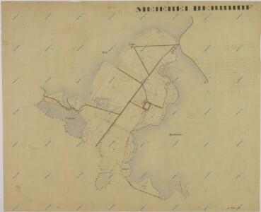
Domanin - c1424-1-006 - Kaiserpflichtexemplar der Landkarten des stabilen Katasters
1 : 2880
Domanin - c1424-1-007 - Kaiserpflichtexemplar der Landkarten des stabilen Katasters
1 : 2880
Domanin - c1424-1-002 - Kaiserpflichtexemplar der Landkarten des stabilen Katasters
1 : 2880
Domanin - c1424-1-001 - Kaiserpflichtexemplar der Landkarten des stabilen Katasters
1 : 2880
Domanin - c1424-1-004 - Kaiserpflichtexemplar der Landkarten des stabilen Katasters
1 : 2880
Domanin - c1424-1-003 - Kaiserpflichtexemplar der Landkarten des stabilen Katasters
1 : 2880
Domanin - c1424-1-005 - Kaiserpflichtexemplar der Landkarten des stabilen Katasters
1 : 2880
Branna - c0470-1-006 - Kaiserpflichtexemplar der Landkarten des stabilen Katasters
1 : 2880
Branna - c0470-1-003 - Kaiserpflichtexemplar der Landkarten des stabilen Katasters
1 : 2880
Branna - c0470-1-007 - Kaiserpflichtexemplar der Landkarten des stabilen Katasters
1 : 2880
Branna - c0470-1-008 - Kaiserpflichtexemplar der Landkarten des stabilen Katasters
1 : 2880
Branna - c0470-1-009 - Kaiserpflichtexemplar der Landkarten des stabilen Katasters
1 : 2880
Branna - c0470-1-004 - Kaiserpflichtexemplar der Landkarten des stabilen Katasters
1 : 2880
Branna - c0470-1-002 - Kaiserpflichtexemplar der Landkarten des stabilen Katasters
1 : 2880
Branna - c0470-1-005 - Kaiserpflichtexemplar der Landkarten des stabilen Katasters
1 : 2880